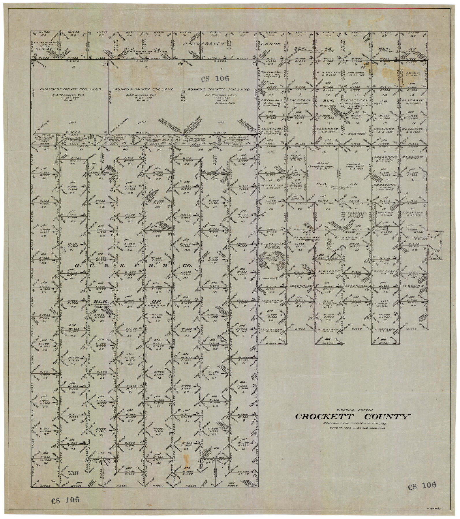
Working Sketch Crockett County
CS106
-
Map/Doc
92608
-
Collection
Twichell Survey Records
-
Object Dates
9/17/1924 (Creation Date)
-
Counties
Crockett
-
Height x Width
31.2 x 35.1 inches
79.3 x 89.2 cm
Part of: Twichell Survey Records
[Block 6T and Vicinity]
![91521, [Block 6T and Vicinity], Twichell Survey Records](https://historictexasmaps.com/wmedia_w700/maps/91521-1.tif.jpg)
Print $20.00
- Digital $50.00
[Block 6T and Vicinity]
Size 19.9 x 15.7 inches
Map/Doc 91521
Gray County, Texas

Print $20.00
- Digital $50.00
Gray County, Texas
Size 13.4 x 14.9 inches
Map/Doc 90722
Pecos County Sketch showing location of oil wells within 1/2 mile radius of the south 8 acres of the Bob Reid survey

Print $20.00
- Digital $50.00
Pecos County Sketch showing location of oil wells within 1/2 mile radius of the south 8 acres of the Bob Reid survey
Size 24.1 x 20.5 inches
Map/Doc 91624
[Block 1 PO, Surveys 15, 16, and 17]
![91433, [Block 1 PO, Surveys 15, 16, and 17], Twichell Survey Records](https://historictexasmaps.com/wmedia_w700/maps/91433-1.tif.jpg)
Print $20.00
- Digital $50.00
[Block 1 PO, Surveys 15, 16, and 17]
1906
Size 16.6 x 15.6 inches
Map/Doc 91433
[T. & N. O. Block 3T, Martinez Survey, and William Heath Survey]
![91523, [T. & N. O. Block 3T, Martinez Survey, and William Heath Survey], Twichell Survey Records](https://historictexasmaps.com/wmedia_w700/maps/91523-1.tif.jpg)
Print $20.00
- Digital $50.00
[T. & N. O. Block 3T, Martinez Survey, and William Heath Survey]
Size 13.5 x 14.2 inches
Map/Doc 91523
Sheet 4 copied from Peck Book 6 [Strip Map showing T. & P. connecting lines]
![93170, Sheet 4 copied from Peck Book 6 [Strip Map showing T. & P. connecting lines], Twichell Survey Records](https://historictexasmaps.com/wmedia_w700/maps/93170-1.tif.jpg)
Print $40.00
- Digital $50.00
Sheet 4 copied from Peck Book 6 [Strip Map showing T. & P. connecting lines]
1909
Size 7.0 x 54.8 inches
Map/Doc 93170
[County School Land for Shackelford, Reeves, Hardeman, Val Verde, Hood, Martin, Rusk, Atascosa, and Edwards Counties]
![91100, [County School Land for Shackelford, Reeves, Hardeman, Val Verde, Hood, Martin, Rusk, Atascosa, and Edwards Counties], Twichell Survey Records](https://historictexasmaps.com/wmedia_w700/maps/91100-1.tif.jpg)
Print $2.00
- Digital $50.00
[County School Land for Shackelford, Reeves, Hardeman, Val Verde, Hood, Martin, Rusk, Atascosa, and Edwards Counties]
Size 7.5 x 6.4 inches
Map/Doc 91100
[T. & P. Blocks 32-36, Townships 3N, 4N and 5N]
![90630, [T. & P. Blocks 32-36, Townships 3N, 4N and 5N], Twichell Survey Records](https://historictexasmaps.com/wmedia_w700/maps/90630.tif.jpg)
Print $20.00
- Digital $50.00
[T. & P. Blocks 32-36, Townships 3N, 4N and 5N]
Size 35.5 x 24.6 inches
Map/Doc 90630

[Capitol Leagues 217-228, 238, and vicinity]
![90672, [Capitol Leagues 217-228, 238, and vicinity], Twichell Survey Records](https://historictexasmaps.com/wmedia_w700/maps/90672-1.tif.jpg)
Print $20.00
- Digital $50.00
[Capitol Leagues 217-228, 238, and vicinity]
Size 23.0 x 9.9 inches
Map/Doc 90672
[Plat showing traverse line run from I. R. Rock at southeast corner survey 58 northerly to the I. R. Rock corner at the northeast 60]
![91598, [Plat showing traverse line run from I. R. Rock at southeast corner survey 58 northerly to the I. R. Rock corner at the northeast 60], Twichell Survey Records](https://historictexasmaps.com/wmedia_w700/maps/91598-1.tif.jpg)
Print $20.00
- Digital $50.00
[Plat showing traverse line run from I. R. Rock at southeast corner survey 58 northerly to the I. R. Rock corner at the northeast 60]
1935
Size 21.7 x 18.0 inches
Map/Doc 91598
[T. & P. Block 33, Township 4N]
![90558, [T. & P. Block 33, Township 4N], Twichell Survey Records](https://historictexasmaps.com/wmedia_w700/maps/90558-1.tif.jpg)
Print $3.00
- Digital $50.00
[T. & P. Block 33, Township 4N]
Size 9.4 x 14.2 inches
Map/Doc 90558
You may also like
Wise County Working Sketch 20

Print $20.00
- Digital $50.00
Wise County Working Sketch 20
1979
Size 22.8 x 27.3 inches
Map/Doc 72634
Garza County Working Sketch 10

Print $20.00
- Digital $50.00
Garza County Working Sketch 10
1953
Size 11.1 x 18.7 inches
Map/Doc 63157
Terrell County Sketch File 35

Print $36.00
- Digital $50.00
Terrell County Sketch File 35
1957
Size 32.0 x 37.6 inches
Map/Doc 10389
Flight Mission No. DIX-5P, Frame 147, Aransas County

Print $20.00
- Digital $50.00
Flight Mission No. DIX-5P, Frame 147, Aransas County
1956
Size 17.8 x 18.1 inches
Map/Doc 83809
Marion County Working Sketch 17

Print $20.00
- Digital $50.00
Marion County Working Sketch 17
1955
Size 31.1 x 26.1 inches
Map/Doc 70793
[E. L. & R. R., Blocks 10, 9, 3, and 1]
![91346, [E. L. & R. R., Blocks 10, 9, 3, and 1], Twichell Survey Records](https://historictexasmaps.com/wmedia_w700/maps/91346-1.tif.jpg)
Print $20.00
- Digital $50.00
[E. L. & R. R., Blocks 10, 9, 3, and 1]
Size 16.0 x 23.0 inches
Map/Doc 91346
Nueces County Sketch File 3

Print $40.00
- Digital $50.00
Nueces County Sketch File 3
1847
Size 12.5 x 15.1 inches
Map/Doc 32503
Morris County Rolled Sketch 2A

Print $20.00
- Digital $50.00
Morris County Rolled Sketch 2A
Size 24.4 x 19.3 inches
Map/Doc 10262
Jeff Davis County Rolled Sketch 32

Print $20.00
- Digital $50.00
Jeff Davis County Rolled Sketch 32
1984
Size 16.3 x 24.5 inches
Map/Doc 7721
Galveston County Working Sketch 9

Print $20.00
- Digital $50.00
Galveston County Working Sketch 9
1948
Size 31.9 x 25.8 inches
Map/Doc 69346
Mills County Working Sketch 28

Print $40.00
- Digital $50.00
Mills County Working Sketch 28
2006
Size 42.0 x 67.4 inches
Map/Doc 85385
Upton County Rolled Sketch 33

Print $20.00
- Digital $50.00
Upton County Rolled Sketch 33
1951
Size 39.2 x 33.0 inches
Map/Doc 8076