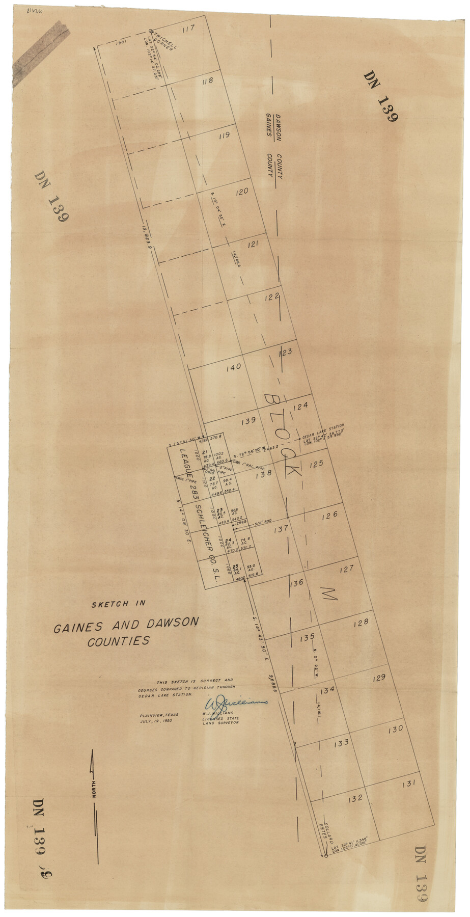
Sketch in Gaines and Dawson Counties
DN139
-
Map/Doc
92586
-
Collection
Twichell Survey Records
-
Object Dates
7/19/1950 (Creation Date)
-
People and Organizations
W.J. Williams (Surveyor/Engineer)
-
Counties
Dawson Gaines
-
Height x Width
16.0 x 31.3 inches
40.6 x 79.5 cm
Part of: Twichell Survey Records
[West and North lines of the Panhandle]
![90576, [West and North lines of the Panhandle], Twichell Survey Records](https://historictexasmaps.com/wmedia_w700/maps/90576-1.tif.jpg)
Print $20.00
- Digital $50.00
[West and North lines of the Panhandle]
1885
Size 22.0 x 32.1 inches
Map/Doc 90576
Levelland Independent School District Hockley County, Texas

Print $20.00
- Digital $50.00
Levelland Independent School District Hockley County, Texas
Size 36.2 x 29.8 inches
Map/Doc 92240
[Portion of Block 178, Block C3 and Sections 48-65, Block 1, I. & G. N.]
![91648, [Portion of Block 178, Block C3 and Sections 48-65, Block 1, I. & G. N.], Twichell Survey Records](https://historictexasmaps.com/wmedia_w700/maps/91648-1.tif.jpg)
Print $2.00
- Digital $50.00
[Portion of Block 178, Block C3 and Sections 48-65, Block 1, I. & G. N.]
Size 9.1 x 14.7 inches
Map/Doc 91648
[Sketch showing surveys on the north side of the Canadian River, Blocks B-11, L, O-18, and G and M 2 and 3]
![91737, [Sketch showing surveys on the north side of the Canadian River, Blocks B-11, L, O-18, and G and M 2 and 3], Twichell Survey Records](https://historictexasmaps.com/wmedia_w700/maps/91737-1.tif.jpg)
Print $20.00
- Digital $50.00
[Sketch showing surveys on the north side of the Canadian River, Blocks B-11, L, O-18, and G and M 2 and 3]
1883
Size 35.4 x 25.3 inches
Map/Doc 91737
Map No. 1 - Surveys Located in 1881 as they appear on the ground

Print $20.00
- Digital $50.00
Map No. 1 - Surveys Located in 1881 as they appear on the ground
Size 29.6 x 18.8 inches
Map/Doc 91889
Witt Addition, Subdivision out of Section 6, Block E, City of Lubbock

Print $20.00
- Digital $50.00
Witt Addition, Subdivision out of Section 6, Block E, City of Lubbock
1950
Size 9.1 x 30.9 inches
Map/Doc 92739
Seminole, Gaines County, Texas

Print $20.00
- Digital $50.00
Seminole, Gaines County, Texas
Size 25.6 x 39.0 inches
Map/Doc 92692
Map Showing Block HG and Connecting Surveys

Print $2.00
- Digital $50.00
Map Showing Block HG and Connecting Surveys
1907
Size 9.2 x 13.7 inches
Map/Doc 90681
[Part of Eastern Texas RR. Co. Block 1]
![91920, [Part of Eastern Texas RR. Co. Block 1], Twichell Survey Records](https://historictexasmaps.com/wmedia_w700/maps/91920-1.tif.jpg)
Print $20.00
- Digital $50.00
[Part of Eastern Texas RR. Co. Block 1]
Size 35.7 x 15.6 inches
Map/Doc 91920
[Skletch filed with corrected field notes of Surveys 27, 28, 29 and 30, Block B-19 Public School Lands]
![93056, [Skletch filed with corrected field notes of Surveys 27, 28, 29 and 30, Block B-19 Public School Lands], Twichell Survey Records](https://historictexasmaps.com/wmedia_w700/maps/93056-1.tif.jpg)
Print $20.00
- Digital $50.00
[Skletch filed with corrected field notes of Surveys 27, 28, 29 and 30, Block B-19 Public School Lands]
1943
Size 19.3 x 15.4 inches
Map/Doc 93056
[Lee County School Land and vicinity]
![90886, [Lee County School Land and vicinity], Twichell Survey Records](https://historictexasmaps.com/wmedia_w700/maps/90886-1.tif.jpg)
Print $2.00
- Digital $50.00
[Lee County School Land and vicinity]
Size 9.0 x 14.8 inches
Map/Doc 90886
Bivin's Addition to Amarillo, Texas, Survey 187, Block 2, A. B. & M., Potter County

Print $20.00
- Digital $50.00
Bivin's Addition to Amarillo, Texas, Survey 187, Block 2, A. B. & M., Potter County
Size 20.1 x 23.0 inches
Map/Doc 91739
You may also like
Coke County Rolled Sketch 14

Print $20.00
- Digital $50.00
Coke County Rolled Sketch 14
Size 26.8 x 18.9 inches
Map/Doc 5514
Shelby County Sketch File 31

Print $20.00
- Digital $50.00
Shelby County Sketch File 31
1949
Size 12.0 x 36.0 inches
Map/Doc 12320
Amistad International Reservoir on Rio Grande 97

Print $20.00
- Digital $50.00
Amistad International Reservoir on Rio Grande 97
1950
Size 28.5 x 41.1 inches
Map/Doc 75528

San Patricio County Sketch File 12

Print $4.00
San Patricio County Sketch File 12
1859
Size 6.6 x 9.9 inches
Map/Doc 36047
DeWitt County Working Sketch 7

Print $20.00
- Digital $50.00
DeWitt County Working Sketch 7
1977
Size 19.0 x 21.2 inches
Map/Doc 68597
[E. T. RR. Block 1]
![93186, [E. T. RR. Block 1], Twichell Survey Records](https://historictexasmaps.com/wmedia_w700/maps/93186-1.tif.jpg)
Print $40.00
- Digital $50.00
[E. T. RR. Block 1]
Size 69.6 x 52.7 inches
Map/Doc 93186
Kinney County Working Sketch 5

Print $20.00
- Digital $50.00
Kinney County Working Sketch 5
1910
Size 20.5 x 24.2 inches
Map/Doc 70187
Swisher County Sketch File 19

Print $16.00
- Digital $50.00
Swisher County Sketch File 19
1913
Size 10.0 x 6.5 inches
Map/Doc 37662
Texas in 1835

Print $20.00
- Digital $50.00
Texas in 1835
1897
Size 13.4 x 15.3 inches
Map/Doc 93414
Hale County Rolled Sketch 10

Print $40.00
- Digital $50.00
Hale County Rolled Sketch 10
Size 52.4 x 28.3 inches
Map/Doc 76447
Typus Orbis Terrarum

Print $20.00
- Digital $50.00
Typus Orbis Terrarum
Size 15.2 x 20.8 inches
Map/Doc 96579