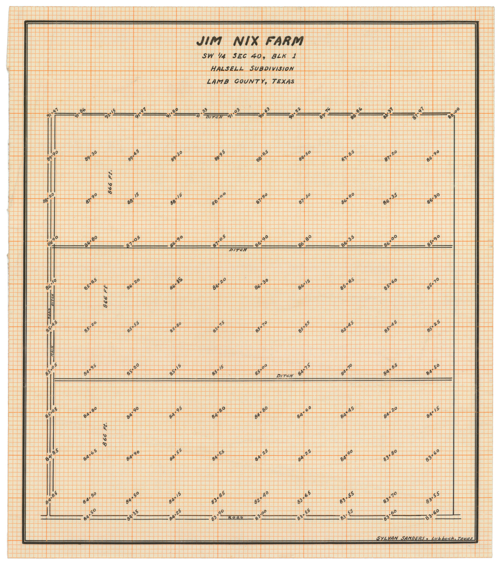
Jim Nix Farm
-
Map/Doc
92428
-
Collection
Twichell Survey Records
-
People and Organizations
Sylvan Sanders (Surveyor/Engineer)
-
Counties
Lamb
-
Height x Width
11.9 x 13.5 inches
30.2 x 34.3 cm
Part of: Twichell Survey Records
[East line of Wheeler County along Oklahoma]
![89825, [East line of Wheeler County along Oklahoma], Twichell Survey Records](https://historictexasmaps.com/wmedia_w700/maps/89825-1.tif.jpg)
Print $40.00
- Digital $50.00
[East line of Wheeler County along Oklahoma]
Size 8.5 x 62.9 inches
Map/Doc 89825
[Blocks 24, B9, 3KA]
![90326, [Blocks 24, B9, 3KA], Twichell Survey Records](https://historictexasmaps.com/wmedia_w700/maps/90326-1.tif.jpg)
Print $20.00
- Digital $50.00
[Blocks 24, B9, 3KA]
Size 18.2 x 14.0 inches
Map/Doc 90326
[H. & T. C. 46, Sections 79- 84]
![91262, [H. & T. C. 46, Sections 79- 84], Twichell Survey Records](https://historictexasmaps.com/wmedia_w700/maps/91262-1.tif.jpg)
Print $20.00
- Digital $50.00
[H. & T. C. 46, Sections 79- 84]
Size 27.3 x 32.6 inches
Map/Doc 91262
[East Portion of Lea County] / [Central part of San Miguel County, New Mexico]
![92033, [East Portion of Lea County] / [Central part of San Miguel County, New Mexico], Twichell Survey Records](https://historictexasmaps.com/wmedia_w700/maps/92033-1.tif.jpg)
Print $20.00
- Digital $50.00
[East Portion of Lea County] / [Central part of San Miguel County, New Mexico]
Size 26.9 x 13.9 inches
Map/Doc 92033
[Subdivision of Lgs. 109-112, Crosby County School Land]
![90154, [Subdivision of Lgs. 109-112, Crosby County School Land], Twichell Survey Records](https://historictexasmaps.com/wmedia_w700/maps/90154-1.tif.jpg)
Print $20.00
- Digital $50.00
[Subdivision of Lgs. 109-112, Crosby County School Land]
Size 11.8 x 21.3 inches
Map/Doc 90154

[Map showing connecting line from New Mexico to Double Lakes]
![91997, [Map showing connecting line from New Mexico to Double Lakes], Twichell Survey Records](https://historictexasmaps.com/wmedia_w700/maps/91997-1.tif.jpg)
Print $20.00
- Digital $50.00
[Map showing connecting line from New Mexico to Double Lakes]
1913
Size 39.3 x 24.2 inches
Map/Doc 91997
Brazos River Conservation and Reclamation District Official Boundary Line Survey

Print $20.00
- Digital $50.00
Brazos River Conservation and Reclamation District Official Boundary Line Survey
1931
Size 25.1 x 36.9 inches
Map/Doc 90125
[Township 3 North, Block 33]
![91215, [Township 3 North, Block 33], Twichell Survey Records](https://historictexasmaps.com/wmedia_w700/maps/91215-1.tif.jpg)
Print $3.00
- Digital $50.00
[Township 3 North, Block 33]
Size 11.2 x 17.0 inches
Map/Doc 91215
Map of Littlefield's Subdivision of State Capitol Leagues 657-687 Situated in Lamb County, Texas

Print $20.00
- Digital $50.00
Map of Littlefield's Subdivision of State Capitol Leagues 657-687 Situated in Lamb County, Texas
Size 38.8 x 29.7 inches
Map/Doc 92231
Grimes Estate Lands, Cochran County, Texas

Print $20.00
- Digital $50.00
Grimes Estate Lands, Cochran County, Texas
Size 25.6 x 21.6 inches
Map/Doc 92520
Mrs. R. L. Westerman Subdivision of 2 1/2 Acres out of North Half of Survey Number 1, Block Number 36, Township 5 North. Dawson County, Texas

Print $20.00
- Digital $50.00
Mrs. R. L. Westerman Subdivision of 2 1/2 Acres out of North Half of Survey Number 1, Block Number 36, Township 5 North. Dawson County, Texas
1924
Size 18.6 x 24.5 inches
Map/Doc 92591
You may also like

Official Highway Map of the State of Vermont

Print $20.00
- Digital $50.00
Official Highway Map of the State of Vermont
1923
Size 44.8 x 28.6 inches
Map/Doc 97112
Flight Mission No. BRA-17M, Frame 2, Jefferson County

Print $20.00
- Digital $50.00
Flight Mission No. BRA-17M, Frame 2, Jefferson County
1953
Size 18.6 x 22.3 inches
Map/Doc 85782
1960 Texas Official Highway Travel Map

Digital $50.00
1960 Texas Official Highway Travel Map
Size 28.4 x 36.2 inches
Map/Doc 94329
Travis County Working Sketch 29

Print $20.00
- Digital $50.00
Travis County Working Sketch 29
1960
Size 25.6 x 29.9 inches
Map/Doc 69413
[Sketch Between Wheeler County and Oklahoma]
![89665, [Sketch Between Wheeler County and Oklahoma], Twichell Survey Records](https://historictexasmaps.com/wmedia_w700/maps/89665-1.tif.jpg)
Print $40.00
- Digital $50.00
[Sketch Between Wheeler County and Oklahoma]
Size 8.8 x 62.7 inches
Map/Doc 89665
Sutton County Working Sketch 64

Print $20.00
- Digital $50.00
Sutton County Working Sketch 64
1963
Size 32.6 x 26.2 inches
Map/Doc 62407
Foard County Rolled Sketch 14

Print $20.00
- Digital $50.00
Foard County Rolled Sketch 14
1923
Size 20.2 x 36.0 inches
Map/Doc 5888
Ward County Working Sketch 9

Print $20.00
- Digital $50.00
Ward County Working Sketch 9
1946
Size 32.9 x 19.2 inches
Map/Doc 72315
University Land Field Notes for Block 19 in Loving and Ward Counties, Block 20 in Loving, Ward, and Winkler Counties, Blocks 16 and 18 in Ward County, Block 17 in Ward and Winkler Counties, and Block 21 in Winkler County

University Land Field Notes for Block 19 in Loving and Ward Counties, Block 20 in Loving, Ward, and Winkler Counties, Blocks 16 and 18 in Ward County, Block 17 in Ward and Winkler Counties, and Block 21 in Winkler County
Map/Doc 81709
Flight Mission No. DIX-5P, Frame 137, Aransas County

Print $20.00
- Digital $50.00
Flight Mission No. DIX-5P, Frame 137, Aransas County
1956
Size 17.6 x 17.6 inches
Map/Doc 83798
Flight Mission No. BRE-1P, Frame 120, Nueces County

Print $20.00
- Digital $50.00
Flight Mission No. BRE-1P, Frame 120, Nueces County
1956
Size 18.6 x 22.8 inches
Map/Doc 86686