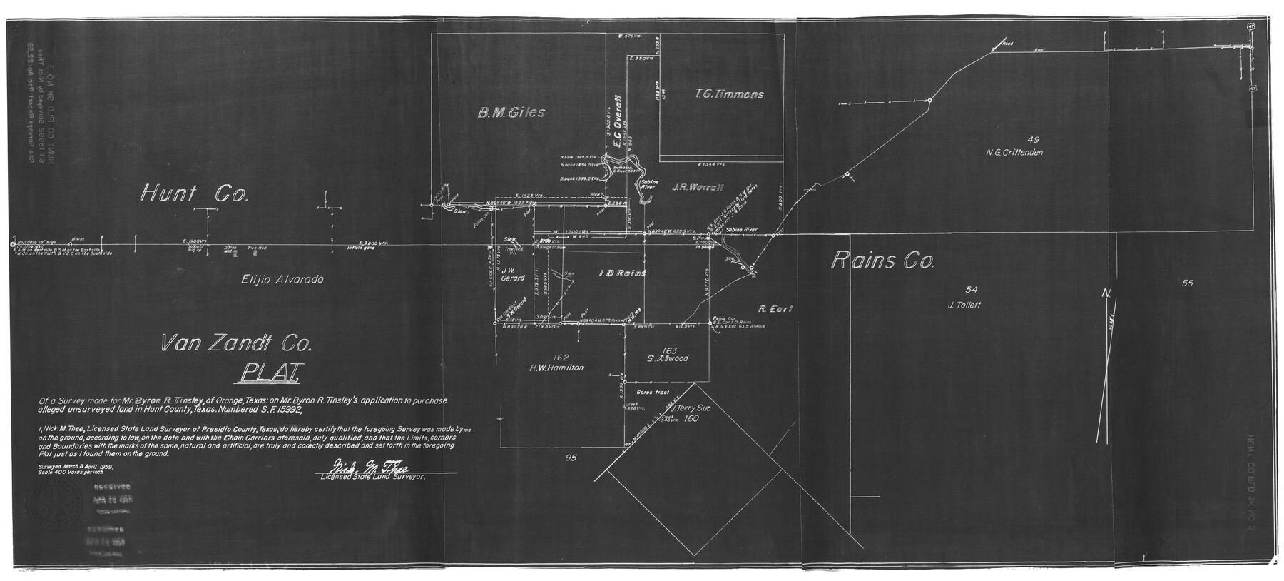
Hunt County Rolled Sketch 3A
Plat of a survey made for Mr. Byron R. Tinsley, of Orange, Texas: on Mr. Byron R. Tinsley's application to purchase alleged unsurveyed land in Hunt County, Texas. Numbered SF-15992
-
Map/Doc
9241
-
Collection
General Map Collection
-
Object Dates
4/1959 (Creation Date)
4/29/1959 (File Date)
-
People and Organizations
Nick M. Thee (Surveyor/Engineer)
-
Counties
Hunt Van Zandt Rains
-
Subjects
Surveying Rolled Sketch
-
Height x Width
23.9 x 52.8 inches
60.7 x 134.1 cm
-
Medium
photostat
-
Scale
1" = 400 varas
Part of: General Map Collection
Hamilton County Working Sketch 7

Print $20.00
- Digital $50.00
Hamilton County Working Sketch 7
1942
Size 15.2 x 20.2 inches
Map/Doc 63345
Reagan County Sketch File 28

Print $20.00
- Digital $50.00
Reagan County Sketch File 28
1951
Size 29.6 x 21.7 inches
Map/Doc 12224
Brazoria County

Print $20.00
- Digital $50.00
Brazoria County
1879
Size 26.6 x 25.1 inches
Map/Doc 859
2016 Official Travel Map, Texas

2016 Official Travel Map, Texas
Size 33.3 x 36.2 inches
Map/Doc 94298
[Plat of Trinity River w/ Midstream Profile in Liberty County by US Government 1899]
![65337, [Plat of Trinity River w/ Midstream Profile in Liberty County by US Government 1899], General Map Collection](https://historictexasmaps.com/wmedia_w700/maps/65337.tif.jpg)
Print $20.00
- Digital $50.00
[Plat of Trinity River w/ Midstream Profile in Liberty County by US Government 1899]
1899
Size 12.3 x 16.7 inches
Map/Doc 65337
Chambers County NRC Article 33.136 Location Key Sheet

Print $20.00
- Digital $50.00
Chambers County NRC Article 33.136 Location Key Sheet
1982
Size 27.0 x 22.0 inches
Map/Doc 87908
Potter County Rolled Sketch 10A

Print $40.00
- Digital $50.00
Potter County Rolled Sketch 10A
1920
Size 43.8 x 50.4 inches
Map/Doc 9760
Jefferson County NRC Article 33.136 Sketch 14

Print $164.00
- Digital $50.00
Jefferson County NRC Article 33.136 Sketch 14
2021
Map/Doc 96645
Lee County Rolled Sketch 1

Print $40.00
- Digital $50.00
Lee County Rolled Sketch 1
1939
Size 71.1 x 45.2 inches
Map/Doc 9562
El Paso County Boundary File 7a

Print $20.00
- Digital $50.00
El Paso County Boundary File 7a
Size 14.2 x 8.3 inches
Map/Doc 53094
[Sketch for Mineral Application 26649-26650 - Sabine River, Harry A. Wolan]
![65565, [Sketch for Mineral Application 26649-26650 - Sabine River, Harry A. Wolan], General Map Collection](https://historictexasmaps.com/wmedia_w700/maps/65565.tif.jpg)
Print $40.00
- Digital $50.00
[Sketch for Mineral Application 26649-26650 - Sabine River, Harry A. Wolan]
Size 36.8 x 71.9 inches
Map/Doc 65565
Plan C, Part 1st Shewing that portion of the boundary between Texas and the United States, included between the intersection of the 32nd degree of Latitude with western bank of Sabine River and the 36th mile mound

Print $20.00
- Digital $50.00
Plan C, Part 1st Shewing that portion of the boundary between Texas and the United States, included between the intersection of the 32nd degree of Latitude with western bank of Sabine River and the 36th mile mound
1842
Size 19.4 x 27.7 inches
Map/Doc 65412
You may also like
[T. & N. O. RR. Co. Block 2]
![92696, [T. & N. O. RR. Co. Block 2], Twichell Survey Records](https://historictexasmaps.com/wmedia_w700/maps/92696-1.tif.jpg)
Print $20.00
- Digital $50.00
[T. & N. O. RR. Co. Block 2]
Size 22.5 x 28.0 inches
Map/Doc 92696
San Jacinto River and Tributaries, Texas - Survey of 1939

Print $20.00
- Digital $50.00
San Jacinto River and Tributaries, Texas - Survey of 1939
1939
Size 28.0 x 40.3 inches
Map/Doc 60307
Fractional Township No. 8 South Range No. 19 East of the Indian Meridian, Indian Territory

Print $20.00
- Digital $50.00
Fractional Township No. 8 South Range No. 19 East of the Indian Meridian, Indian Territory
1897
Size 19.1 x 24.2 inches
Map/Doc 75234
[Sketch showing San Augustine, Morris, Stephens and Eastland School Land Leagues and adjacent Blocks]
![89918, [Sketch showing San Augustine, Morris, Stephens and Eastland School Land Leagues and adjacent Blocks], Twichell Survey Records](https://historictexasmaps.com/wmedia_w700/maps/89918-1.tif.jpg)
Print $40.00
- Digital $50.00
[Sketch showing San Augustine, Morris, Stephens and Eastland School Land Leagues and adjacent Blocks]
Size 54.7 x 43.5 inches
Map/Doc 89918
Ector County Working Sketch 32

Print $20.00
- Digital $50.00
Ector County Working Sketch 32
1981
Size 26.2 x 17.0 inches
Map/Doc 68875
A new map for travellers through the United States of America showing the railroads, canals & stageroads with the distances

Print $20.00
- Digital $50.00
A new map for travellers through the United States of America showing the railroads, canals & stageroads with the distances
1846
Size 22.4 x 27.9 inches
Map/Doc 95921
Map of Claude - Claude, Armstrong Co.

Print $20.00
- Digital $50.00
Map of Claude - Claude, Armstrong Co.
Size 46.9 x 38.5 inches
Map/Doc 89743
Hays County Boundary File 3

Print $20.00
- Digital $50.00
Hays County Boundary File 3
Size 11.2 x 8.8 inches
Map/Doc 54597
Map of Nacogdoches County

Print $20.00
- Digital $50.00
Map of Nacogdoches County
1881
Size 25.2 x 20.7 inches
Map/Doc 4601
[Sketch for Mineral Application 26501 - Sabine River, T. A. Oldhausen]
![2843, [Sketch for Mineral Application 26501 - Sabine River, T. A. Oldhausen], General Map Collection](https://historictexasmaps.com/wmedia_w700/maps/2843.tif.jpg)
Print $20.00
- Digital $50.00
[Sketch for Mineral Application 26501 - Sabine River, T. A. Oldhausen]
1931
Size 23.8 x 36.2 inches
Map/Doc 2843
McMullen County Working Sketch 55

Print $20.00
- Digital $50.00
McMullen County Working Sketch 55
1983
Size 15.2 x 19.2 inches
Map/Doc 70756
Nueces County Sketch File 2

Print $24.00
- Digital $50.00
Nueces County Sketch File 2
1847
Size 7.6 x 12.5 inches
Map/Doc 32500