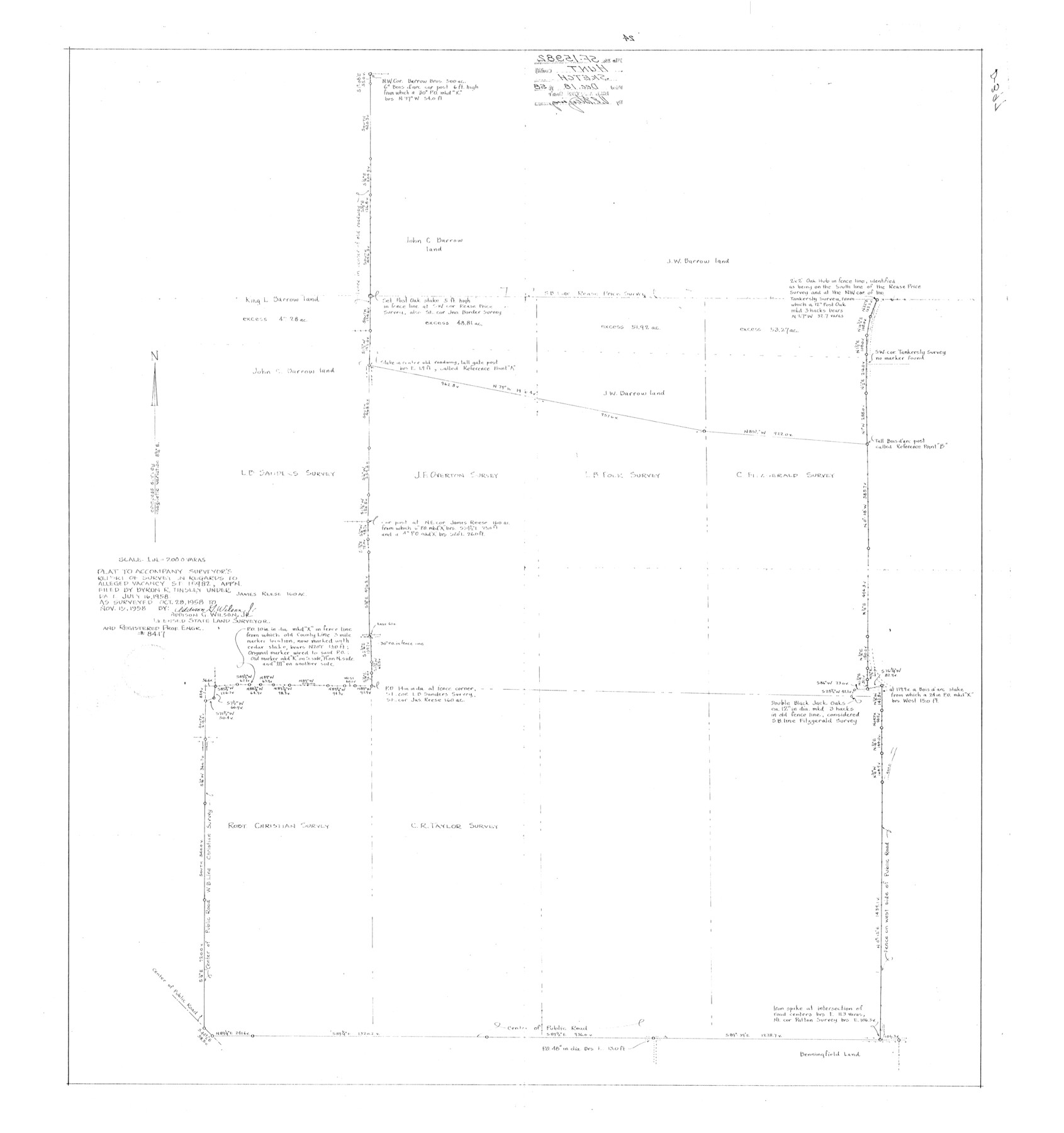
Hunt County Rolled Sketch 2
Byron R. Tinsley, SF.15982, Hunt County, Texas
-
Map/Doc
9240
-
Collection
General Map Collection
-
Counties
Hunt
-
Subjects
Surveying Rolled Sketch
-
Height x Width
31.8 x 29.9 inches
80.8 x 76.0 cm
Part of: General Map Collection
Shelby County Sketch File 14

Print $4.00
- Digital $50.00
Shelby County Sketch File 14
1872
Size 9.8 x 8.9 inches
Map/Doc 36622
Duval County Sketch File 42

Print $4.00
- Digital $50.00
Duval County Sketch File 42
1936
Size 14.4 x 8.8 inches
Map/Doc 21394
Hudspeth County Working Sketch 53-2

Print $40.00
- Digital $50.00
Hudspeth County Working Sketch 53-2
1988
Size 49.9 x 43.3 inches
Map/Doc 78210
Hemphill County Rolled Sketch 10

Print $20.00
- Digital $50.00
Hemphill County Rolled Sketch 10
Size 19.4 x 27.6 inches
Map/Doc 6192
Hansford County Working Sketch 8

Print $20.00
- Digital $50.00
Hansford County Working Sketch 8
1971
Size 26.2 x 19.3 inches
Map/Doc 63380

North Sulphur River, Bartley Gin Sheet

Print $20.00
- Digital $50.00
North Sulphur River, Bartley Gin Sheet
1928
Size 13.3 x 22.0 inches
Map/Doc 78323
Childress County Sketch File 16a

Print $16.00
- Digital $50.00
Childress County Sketch File 16a
1901
Size 13.3 x 8.3 inches
Map/Doc 18309
Erath County Sketch File 10a

Print $4.00
- Digital $50.00
Erath County Sketch File 10a
1871
Size 8.0 x 12.8 inches
Map/Doc 22277
Austin County Working Sketch 3

Print $20.00
- Digital $50.00
Austin County Working Sketch 3
1950
Size 33.3 x 40.1 inches
Map/Doc 67244
Briscoe County Rolled Sketch 11A

Print $20.00
- Digital $50.00
Briscoe County Rolled Sketch 11A
1913
Size 11.7 x 12.3 inches
Map/Doc 5329
[Gonzales District]
![16837, [Gonzales District], General Map Collection](https://historictexasmaps.com/wmedia_w700/maps/16837.tif.jpg)
Print $20.00
- Digital $50.00
[Gonzales District]
1840
Size 42.8 x 37.0 inches
Map/Doc 16837
You may also like
San Jacinto County Working Sketch 37

Print $20.00
- Digital $50.00
San Jacinto County Working Sketch 37
1965
Size 32.7 x 42.6 inches
Map/Doc 63750
General Highway Map, Leon County, Texas

Print $20.00
General Highway Map, Leon County, Texas
1940
Size 18.3 x 24.9 inches
Map/Doc 79172
Henderson County Working Sketch 43

Print $20.00
- Digital $50.00
Henderson County Working Sketch 43
1994
Size 36.7 x 39.0 inches
Map/Doc 66176
[Map of Nacogdoches County]
![10784, [Map of Nacogdoches County], General Map Collection](https://historictexasmaps.com/wmedia_w700/maps/10784-1.tif.jpg)
Print $40.00
- Digital $50.00
[Map of Nacogdoches County]
1840
Size 79.3 x 69.8 inches
Map/Doc 10784
Fisher County

Print $40.00
- Digital $50.00
Fisher County
1944
Size 48.4 x 42.5 inches
Map/Doc 73147
Military Map of Southwestern Texas

Print $20.00
Military Map of Southwestern Texas
1881
Size 24.3 x 38.4 inches
Map/Doc 76316
Cameron County Rolled Sketch 20B

Print $20.00
- Digital $50.00
Cameron County Rolled Sketch 20B
Size 24.3 x 12.7 inches
Map/Doc 5473
Montgomery County Sketch File 8

Print $4.00
- Digital $50.00
Montgomery County Sketch File 8
1862
Size 12.2 x 8.2 inches
Map/Doc 31793
San Jacinto County Sketch File 16

Print $4.00
San Jacinto County Sketch File 16
1934
Size 11.3 x 8.7 inches
Map/Doc 35729
Flight Mission No. BRE-1P, Frame 56, Nueces County

Print $20.00
- Digital $50.00
Flight Mission No. BRE-1P, Frame 56, Nueces County
1956
Size 18.5 x 22.4 inches
Map/Doc 86645
Sterling County Working Sketch 11

Print $20.00
- Digital $50.00
Sterling County Working Sketch 11
1987
Size 20.1 x 40.8 inches
Map/Doc 63993
Harris County Rolled Sketch ACS

Print $40.00
- Digital $50.00
Harris County Rolled Sketch ACS
1933
Size 32.7 x 52.8 inches
Map/Doc 8343