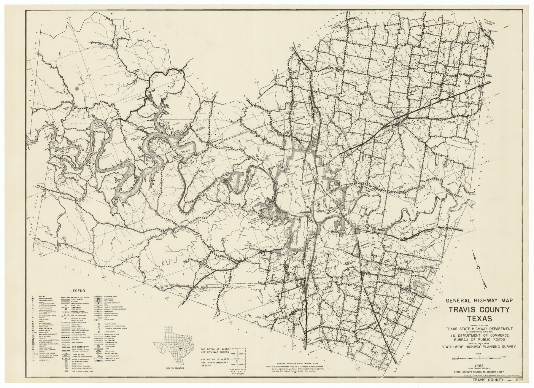
General Highway Map Travis County
-
Map/Doc
92288
-
Collection
Twichell Survey Records
-
Object Dates
1952 (Creation Date)
-
People and Organizations
Texas State Highway Department (Compiler)
-
Counties
Travis
-
Height x Width
17.2 x 12.5 inches
43.7 x 31.8 cm
Part of: Twichell Survey Records
[Capitol Leagues 217-228, 238, and vicinity]
![90674, [Capitol Leagues 217-228, 238, and vicinity], Twichell Survey Records](https://historictexasmaps.com/wmedia_w700/maps/90674-1.tif.jpg)
Print $20.00
- Digital $50.00
[Capitol Leagues 217-228, 238, and vicinity]
Size 22.8 x 10.0 inches
Map/Doc 90674
[Garza, Blanco, Uvalde and Crosby County School Land]
![90250, [Garza, Blanco, Uvalde and Crosby County School Land], Twichell Survey Records](https://historictexasmaps.com/wmedia_w700/maps/90250-1.tif.jpg)
Print $3.00
- Digital $50.00
[Garza, Blanco, Uvalde and Crosby County School Land]
1913
Size 14.6 x 11.8 inches
Map/Doc 90250
[Blocks M1 and 3T]
![91515, [Blocks M1 and 3T], Twichell Survey Records](https://historictexasmaps.com/wmedia_w700/maps/91515-1.tif.jpg)
Print $20.00
- Digital $50.00
[Blocks M1 and 3T]
Size 10.1 x 26.3 inches
Map/Doc 91515
Sheet 2 copied from Peck Book 6 [Strip Map showing T. & P. connecting lines]
![93172, Sheet 2 copied from Peck Book 6 [Strip Map showing T. & P. connecting lines], Twichell Survey Records](https://historictexasmaps.com/wmedia_w700/maps/93172-1.tif.jpg)
Print $40.00
- Digital $50.00
Sheet 2 copied from Peck Book 6 [Strip Map showing T. & P. connecting lines]
1909
Size 6.5 x 53.9 inches
Map/Doc 93172
Sylvan Sanders Map of Gaines County, Texas

Print $40.00
- Digital $50.00
Sylvan Sanders Map of Gaines County, Texas
Size 54.3 x 40.8 inches
Map/Doc 89844
Sheet 5 copied from Champlin Book 5 [Strip Map showing T. & P. connecting lines]
![93180, Sheet 5 copied from Champlin Book 5 [Strip Map showing T. & P. connecting lines], Twichell Survey Records](https://historictexasmaps.com/wmedia_w700/maps/93180-1.tif.jpg)
Print $40.00
- Digital $50.00
Sheet 5 copied from Champlin Book 5 [Strip Map showing T. & P. connecting lines]
1909
Size 7.9 x 75.6 inches
Map/Doc 93180

Sketch in Gray County

Print $3.00
- Digital $50.00
Sketch in Gray County
1899
Size 10.2 x 11.6 inches
Map/Doc 90659
[Sabine County School Land and vicinity]
![90981, [Sabine County School Land and vicinity], Twichell Survey Records](https://historictexasmaps.com/wmedia_w700/maps/90981-1.tif.jpg)
Print $20.00
- Digital $50.00
[Sabine County School Land and vicinity]
Size 18.1 x 19.9 inches
Map/Doc 90981
[Hutchinson County, Blocks R, XO, M-22, M-25]
![91152, [Hutchinson County, Blocks R, XO, M-22, M-25], Twichell Survey Records](https://historictexasmaps.com/wmedia_w700/maps/91152-1.tif.jpg)
Print $20.00
- Digital $50.00
[Hutchinson County, Blocks R, XO, M-22, M-25]
Size 28.5 x 25.9 inches
Map/Doc 91152
Sec. 22, Block 103

Print $20.00
- Digital $50.00
Sec. 22, Block 103
Size 13.1 x 14.8 inches
Map/Doc 90120
[North line of T. C. RR. Blk on North County Line]
![90516, [North line of T. C. RR. Blk on North County Line], Twichell Survey Records](https://historictexasmaps.com/wmedia_w700/maps/90516-1.tif.jpg)
Print $2.00
- Digital $50.00
[North line of T. C. RR. Blk on North County Line]
Size 13.7 x 5.1 inches
Map/Doc 90516
You may also like
Fort Bend County Working Sketch 13

Print $20.00
- Digital $50.00
Fort Bend County Working Sketch 13
1946
Size 29.0 x 29.3 inches
Map/Doc 69218
Hansford County Sketch File 11

Print $6.00
- Digital $50.00
Hansford County Sketch File 11
Size 11.2 x 8.7 inches
Map/Doc 24972
Plot of a survey made to connect the surveys in Jackson County with those heretofore made in connection with Colorado County

Print $2.00
- Digital $50.00
Plot of a survey made to connect the surveys in Jackson County with those heretofore made in connection with Colorado County
1847
Size 12.8 x 7.7 inches
Map/Doc 188
Webb County Sketch File 70

Print $26.00
- Digital $50.00
Webb County Sketch File 70
Size 11.4 x 8.9 inches
Map/Doc 39875
Val Verde County Sketch File Z5

Print $20.00
- Digital $50.00
Val Verde County Sketch File Z5
Size 32.3 x 26.1 inches
Map/Doc 12551
General Highway Map, Bowie County, Texas

Print $20.00
General Highway Map, Bowie County, Texas
1961
Size 18.2 x 25.0 inches
Map/Doc 79380
Flight Mission No. CLL-3N, Frame 9, Willacy County

Print $20.00
- Digital $50.00
Flight Mission No. CLL-3N, Frame 9, Willacy County
1954
Size 18.5 x 22.3 inches
Map/Doc 87075
Angelina County Working Sketch 32b

Print $20.00
- Digital $50.00
Angelina County Working Sketch 32b
1955
Size 23.0 x 28.6 inches
Map/Doc 67115
Brewster County Rolled Sketch 82A

Print $40.00
- Digital $50.00
Brewster County Rolled Sketch 82A
1952
Size 74.3 x 34.0 inches
Map/Doc 8498
St. L. S.-W. Ry. of Texas, Map of Lufkin Branch in Smith County, Texas

Print $20.00
- Digital $50.00
St. L. S.-W. Ry. of Texas, Map of Lufkin Branch in Smith County, Texas
1912
Size 23.1 x 37.2 inches
Map/Doc 64694
Flight Mission No. DCL-6C, Frame 66, Kenedy County

Print $20.00
- Digital $50.00
Flight Mission No. DCL-6C, Frame 66, Kenedy County
1943
Size 18.7 x 22.4 inches
Map/Doc 85908
Hill Ranch, Gaines County, Texas

Print $20.00
- Digital $50.00
Hill Ranch, Gaines County, Texas
1952
Size 12.9 x 18.6 inches
Map/Doc 92675