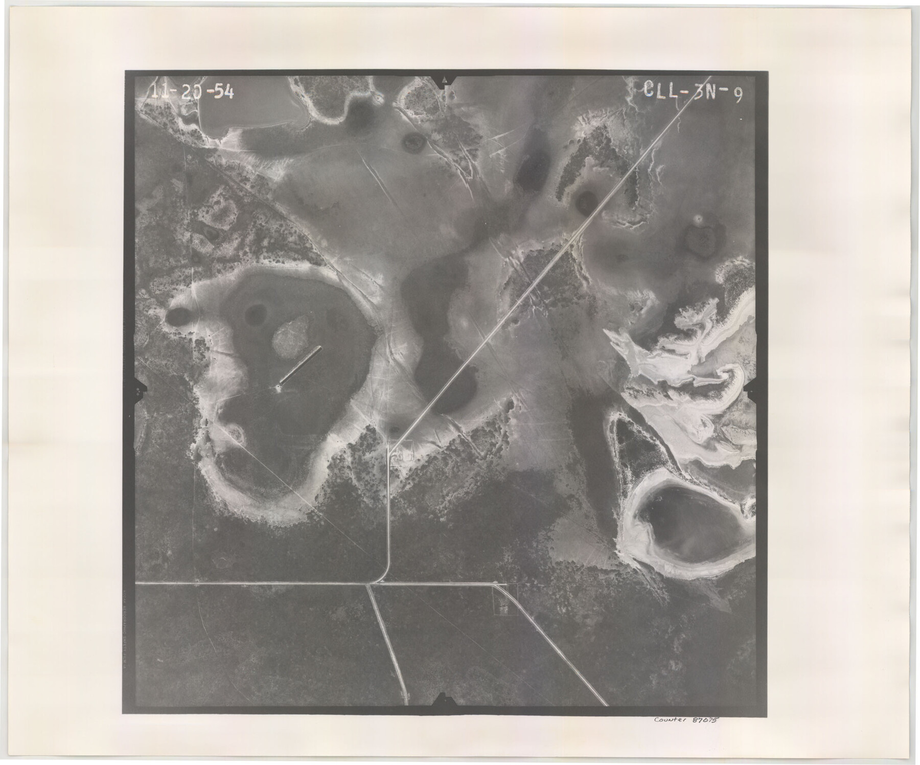
Flight Mission No. CLL-3N, Frame 9, Willacy County
CLL-3N-9
-
Map/Doc
87075
-
Collection
General Map Collection
-
Object Dates
1954/11/20 (Creation Date)
-
People and Organizations
U. S. Department of Agriculture (Publisher)
-
Counties
Willacy
-
Subjects
Aerial Photograph
-
Height x Width
18.5 x 22.3 inches
47.0 x 56.6 cm
-
Comments
Flown by Puckett Aerial Surveys, Inc. of Jackson, Mississippi.
Part of: General Map Collection
Map of Bell County

Print $40.00
- Digital $50.00
Map of Bell County
1896
Size 46.7 x 53.7 inches
Map/Doc 4884
Maps & Lists Showing Prison Lands (Oil & Gas) Leased as of June 1955

Digital $50.00
Maps & Lists Showing Prison Lands (Oil & Gas) Leased as of June 1955
Size 11.1 x 9.0 inches
Map/Doc 62872
Outer Continental Shelf Leasing Maps (Louisiana Offshore Operations)

Print $20.00
- Digital $50.00
Outer Continental Shelf Leasing Maps (Louisiana Offshore Operations)
1954
Size 13.0 x 15.0 inches
Map/Doc 76111
Travis County Sketch File 5

Print $4.00
- Digital $50.00
Travis County Sketch File 5
Size 11.0 x 8.2 inches
Map/Doc 38281
[Caddo Lake & Subdivisions]
![2896, [Caddo Lake & Subdivisions], General Map Collection](https://historictexasmaps.com/wmedia_w700/maps/2896-1.tif.jpg)
Print $20.00
- Digital $50.00
[Caddo Lake & Subdivisions]
1918
Size 31.3 x 28.6 inches
Map/Doc 2896
Moore County Rolled Sketch 16A

Print $20.00
- Digital $50.00
Moore County Rolled Sketch 16A
1982
Size 21.1 x 33.4 inches
Map/Doc 6834
Presidio County Sketch File 58a

Print $14.00
- Digital $50.00
Presidio County Sketch File 58a
1980
Size 11.2 x 8.8 inches
Map/Doc 34628
Comanche County Sketch File 10

Print $4.00
- Digital $50.00
Comanche County Sketch File 10
1859
Size 8.4 x 16.0 inches
Map/Doc 19070
Galveston Bay from a Spanish M. S.

Print $20.00
- Digital $50.00
Galveston Bay from a Spanish M. S.
1846
Size 25.1 x 18.2 inches
Map/Doc 72759
Montgomery County Rolled Sketch 42

Print $20.00
- Digital $50.00
Montgomery County Rolled Sketch 42
1939
Size 13.9 x 20.2 inches
Map/Doc 6820
Brown County Sketch File 20

Print $10.00
- Digital $50.00
Brown County Sketch File 20
Size 6.6 x 8.3 inches
Map/Doc 16620
Erath County Sketch File 13

Print $4.00
- Digital $50.00
Erath County Sketch File 13
1871
Size 7.9 x 6.6 inches
Map/Doc 22285
You may also like
[I. & G. N. Block 1]
![91592, [I. & G. N. Block 1], Twichell Survey Records](https://historictexasmaps.com/wmedia_w700/maps/91592-1.tif.jpg)
Print $20.00
- Digital $50.00
[I. & G. N. Block 1]
Size 17.2 x 18.1 inches
Map/Doc 91592
[F. W. & D. C. Ry. Co. Alignment and Right of Way Map, Clay County]
![64736, [F. W. & D. C. Ry. Co. Alignment and Right of Way Map, Clay County], General Map Collection](https://historictexasmaps.com/wmedia_w700/maps/64736-GC.tif.jpg)
Print $20.00
- Digital $50.00
[F. W. & D. C. Ry. Co. Alignment and Right of Way Map, Clay County]
1927
Size 18.6 x 11.7 inches
Map/Doc 64736
Flight Mission No. DQO-14T, Frame 66, Galveston County

Print $20.00
- Digital $50.00
Flight Mission No. DQO-14T, Frame 66, Galveston County
1958
Size 17.6 x 17.4 inches
Map/Doc 85217
Pecos County Rolled Sketch 117

Print $40.00
- Digital $50.00
Pecos County Rolled Sketch 117
1944
Size 44.6 x 52.6 inches
Map/Doc 9722
Sketch for Mineral Application 26543 (D. H. Sanford) - 243.37 Acres

Print $3.00
- Digital $50.00
Sketch for Mineral Application 26543 (D. H. Sanford) - 243.37 Acres
1931
Size 16.6 x 3.7 inches
Map/Doc 65679
McLennan County Sketch File 2

Print $6.00
- Digital $50.00
McLennan County Sketch File 2
1856
Size 11.5 x 7.7 inches
Map/Doc 31230
Galveston County Rolled Sketch 15

Print $20.00
- Digital $50.00
Galveston County Rolled Sketch 15
Size 24.7 x 31.2 inches
Map/Doc 5954
Crockett County Working Sketch Graphic Index - northwest part - sheet A

Print $40.00
- Digital $50.00
Crockett County Working Sketch Graphic Index - northwest part - sheet A
1983
Size 37.0 x 48.2 inches
Map/Doc 76509
Travis County Working Sketch 11

Print $20.00
- Digital $50.00
Travis County Working Sketch 11
1919
Size 28.3 x 22.3 inches
Map/Doc 69395
Crockett County Sketch File 23

Print $2.00
- Digital $50.00
Crockett County Sketch File 23
Size 8.6 x 8.5 inches
Map/Doc 19697
[County Line between DeWitt and Lavaca Counties]
![65355, [County Line between DeWitt and Lavaca Counties], General Map Collection](https://historictexasmaps.com/wmedia_w700/pdf_converted_jpg/qi_pdf_thumbnail_19782.jpg)
Print $226.00
- Digital $50.00
[County Line between DeWitt and Lavaca Counties]
1906
Size 17.4 x 34.4 inches
Map/Doc 65355
Shackelford County Boundary File 7

Print $74.00
- Digital $50.00
Shackelford County Boundary File 7
Size 11.6 x 8.9 inches
Map/Doc 58671