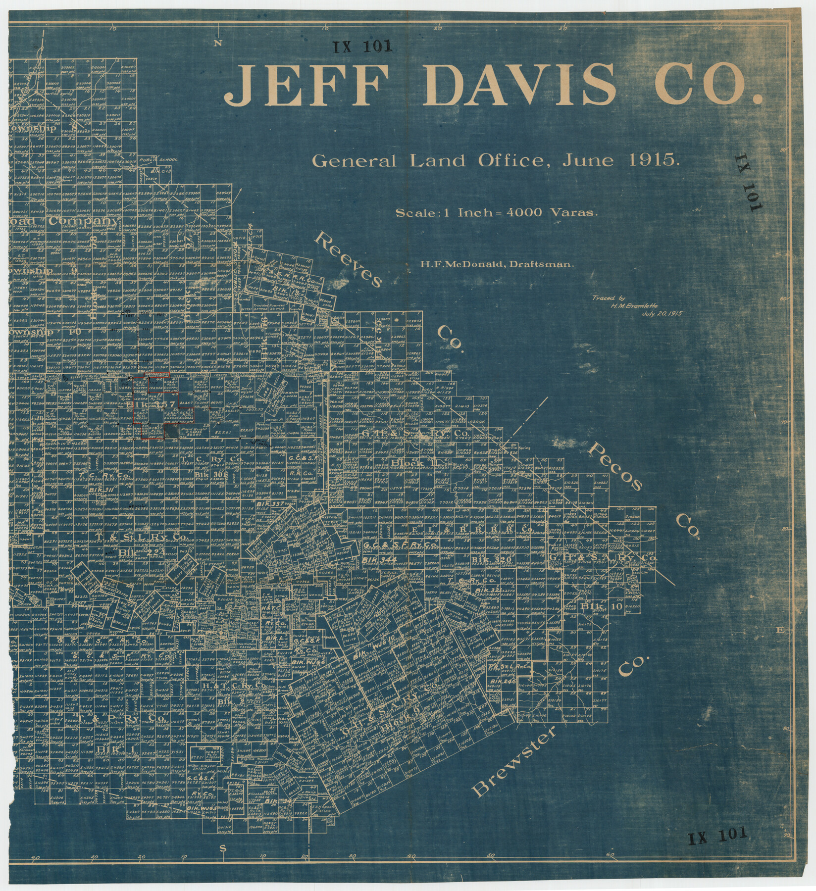
Jeff Davis Co.
IX101
-
Map/Doc
92174
-
Collection
Twichell Survey Records
-
Object Dates
6/1915 (Creation Date)
-
People and Organizations
H.F. McDonald (Draftsman)
-
Counties
King Knox
-
Subjects
County
-
Height x Width
26.0 x 28.0 inches
66.0 x 71.1 cm
Part of: Twichell Survey Records
![92508, [Block A31], Twichell Survey Records](https://historictexasmaps.com/wmedia_w700/maps/92508-1.tif.jpg)
Map of Geo. W. Littlefield's Ranch Located on State Capitol Leagues 657-736 Situated in Lamb and Hockley Counties

Print $20.00
- Digital $50.00
Map of Geo. W. Littlefield's Ranch Located on State Capitol Leagues 657-736 Situated in Lamb and Hockley Counties
Size 29.7 x 45.6 inches
Map/Doc 91223
[E. T. Ry. Blk. 1]
![89796, [E. T. Ry. Blk. 1], Twichell Survey Records](https://historictexasmaps.com/wmedia_w700/maps/89796-1.tif.jpg)
Print $40.00
- Digital $50.00
[E. T. Ry. Blk. 1]
Size 41.1 x 50.4 inches
Map/Doc 89796
[Capitol Leagues Eastward from Bl, LC2 to H. & T.C. Blk. 44]
![89922, [Capitol Leagues Eastward from Bl, LC2 to H. & T.C. Blk. 44], Twichell Survey Records](https://historictexasmaps.com/wmedia_w700/maps/89922-1.tif.jpg)
Print $40.00
- Digital $50.00
[Capitol Leagues Eastward from Bl, LC2 to H. & T.C. Blk. 44]
Size 64.0 x 38.5 inches
Map/Doc 89922
Parkland Place, An Addition to Muleshoe

Print $20.00
- Digital $50.00
Parkland Place, An Addition to Muleshoe
1955
Size 39.2 x 30.3 inches
Map/Doc 92531


Tom Green County

Print $40.00
- Digital $50.00
Tom Green County
1927
Size 42.5 x 48.3 inches
Map/Doc 93253
Revised Sectional Map Number 2, Showing Land Surveys in Counties of Howard, Martin, Andrews, Glasscock, Midland, Ector, and Portions of Borden, Dawson, Irion, Reagan, Upton, Crane, Ward, and Winkler, Texas

Print $20.00
- Digital $50.00
Revised Sectional Map Number 2, Showing Land Surveys in Counties of Howard, Martin, Andrews, Glasscock, Midland, Ector, and Portions of Borden, Dawson, Irion, Reagan, Upton, Crane, Ward, and Winkler, Texas
Size 20.0 x 25.4 inches
Map/Doc 91358
[M. B. & B. Blks. A, B & C near Coyote Lake]
![90249, [M. B. & B. Blks. A, B & C near Coyote Lake], Twichell Survey Records](https://historictexasmaps.com/wmedia_w700/maps/90249-1.tif.jpg)
Print $20.00
- Digital $50.00
[M. B. & B. Blks. A, B & C near Coyote Lake]
Size 15.4 x 23.3 inches
Map/Doc 90249
[Block Y, Walker County School Land, and vicinity]
![92536, [Block Y, Walker County School Land, and vicinity], Twichell Survey Records](https://historictexasmaps.com/wmedia_w700/maps/92536-1.tif.jpg)
Print $20.00
- Digital $50.00
[Block Y, Walker County School Land, and vicinity]
Size 23.3 x 24.8 inches
Map/Doc 92536
[H. & T. C. RR. Company, Block 46, Sections 60- 69]
![91253, [H. & T. C. RR. Company, Block 46, Sections 60- 69], Twichell Survey Records](https://historictexasmaps.com/wmedia_w700/maps/91253-1.tif.jpg)
Print $20.00
- Digital $50.00
[H. & T. C. RR. Company, Block 46, Sections 60- 69]
Size 29.8 x 18.3 inches
Map/Doc 91253
You may also like
Haskell County

Print $20.00
- Digital $50.00
Haskell County
1933
Size 41.7 x 36.2 inches
Map/Doc 77307
Atascosa County Working Sketch 28

Print $20.00
- Digital $50.00
Atascosa County Working Sketch 28
1968
Size 38.5 x 26.3 inches
Map/Doc 67224
Topographic Map of Texas and Oklahoma Boundary, Fort Augur Area

Print $20.00
Topographic Map of Texas and Oklahoma Boundary, Fort Augur Area
1924
Size 20.3 x 33.0 inches
Map/Doc 79753
Duval County Rolled Sketch WSR

Print $20.00
- Digital $50.00
Duval County Rolled Sketch WSR
1938
Size 39.2 x 26.8 inches
Map/Doc 5772
Best Route for Movements of Troops from Laredo to Ringold [sic] Barracks, Texas
![79299, Best Route for Movements of Troops from Laredo to Ringold [sic] Barracks, Texas, Texas State Library and Archives](https://historictexasmaps.com/wmedia_w700/maps/79299.tif.jpg)
Print $20.00
Best Route for Movements of Troops from Laredo to Ringold [sic] Barracks, Texas
1865
Size 18.9 x 15.3 inches
Map/Doc 79299
Galveston County Sketch File 32

Print $20.00
- Digital $50.00
Galveston County Sketch File 32
1916
Size 15.2 x 34.3 inches
Map/Doc 11535
[Galveston, Harrisburg & San Antonio Railroad from Cuero to Stockdale]
![64185, [Galveston, Harrisburg & San Antonio Railroad from Cuero to Stockdale], General Map Collection](https://historictexasmaps.com/wmedia_w700/maps/64185.tif.jpg)
Print $20.00
- Digital $50.00
[Galveston, Harrisburg & San Antonio Railroad from Cuero to Stockdale]
1906
Size 13.6 x 34.0 inches
Map/Doc 64185
Stonewall County Working Sketch 32

Print $20.00
- Digital $50.00
Stonewall County Working Sketch 32
1983
Size 27.9 x 36.2 inches
Map/Doc 62339
Schleicher County

Print $40.00
- Digital $50.00
Schleicher County
1940
Size 39.4 x 56.0 inches
Map/Doc 63028
Edwards County Working Sketch 119

Print $20.00
- Digital $50.00
Edwards County Working Sketch 119
1975
Size 38.8 x 38.7 inches
Map/Doc 68995
Harris County Working Sketch 60

Print $20.00
- Digital $50.00
Harris County Working Sketch 60
1953
Size 31.8 x 35.2 inches
Map/Doc 65952
Flight Mission No. DCL-7C, Frame 67, Kenedy County

Print $20.00
- Digital $50.00
Flight Mission No. DCL-7C, Frame 67, Kenedy County
1943
Size 15.5 x 15.3 inches
Map/Doc 86053