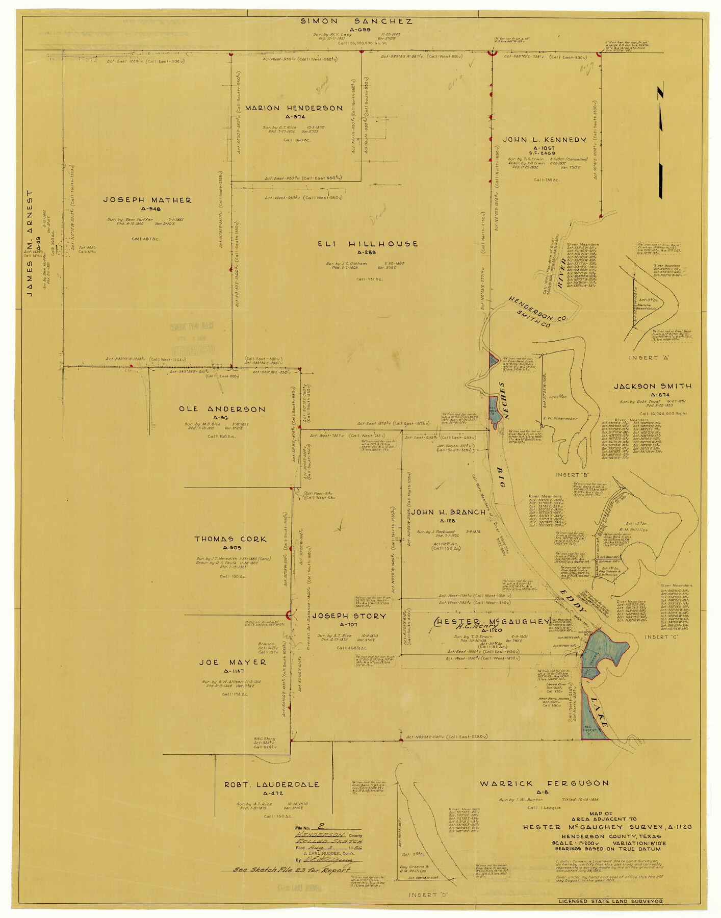
Henderson County Rolled Sketch 2
Map of area adjacent to Hester McGaughey survey, A-1120
-
Map/Doc
9160
-
Collection
General Map Collection
-
Object Dates
1956/7/28 (Survey Date)
1956/8/3 (File Date)
1956/8/2 (Creation Date)
-
People and Organizations
John Cowan (Surveyor/Engineer)
-
Counties
Henderson
-
Subjects
Surveying Rolled Sketch
-
Height x Width
33.7 x 26.5 inches
85.6 x 67.3 cm
-
Medium
van dyke/brownline/sepia
-
Scale
1" = 200 varas
-
Comments
See Henderson County Sketch File 23 (26372) for report.
Related maps
Henderson County Sketch File 23

Print $38.00
- Digital $50.00
Henderson County Sketch File 23
1956
Size 9.1 x 9.1 inches
Map/Doc 26372
Part of: General Map Collection
Travis County Sketch File 77

Print $26.00
- Digital $50.00
Travis County Sketch File 77
2004
Size 11.0 x 8.5 inches
Map/Doc 83254
Jasper County Working Sketch 17

Print $20.00
- Digital $50.00
Jasper County Working Sketch 17
1934
Size 18.1 x 24.2 inches
Map/Doc 66479
Houston Ship Channel, Alexander Island to Carpenter Bayou

Print $40.00
- Digital $50.00
Houston Ship Channel, Alexander Island to Carpenter Bayou
1982
Size 35.7 x 49.4 inches
Map/Doc 69914
Angelina River, Mud Creek, Sheet 2

Print $4.00
- Digital $50.00
Angelina River, Mud Creek, Sheet 2
1937
Size 26.4 x 18.9 inches
Map/Doc 65076
Starr County Working Sketch 17

Print $20.00
- Digital $50.00
Starr County Working Sketch 17
1982
Size 46.1 x 42.7 inches
Map/Doc 63933
Nolan County Sketch File B

Print $20.00
- Digital $50.00
Nolan County Sketch File B
1902
Size 12.0 x 21.5 inches
Map/Doc 42171
La Salle County Sketch File 35

Print $40.00
- Digital $50.00
La Salle County Sketch File 35
Size 12.1 x 19.7 inches
Map/Doc 29587
Waller County Working Sketch 3

Print $20.00
- Digital $50.00
Waller County Working Sketch 3
1959
Size 35.4 x 28.8 inches
Map/Doc 72302
Fort Bend Co.

Print $20.00
- Digital $50.00
Fort Bend Co.
1931
Size 39.1 x 40.8 inches
Map/Doc 73150
San Jacinto County

Print $40.00
- Digital $50.00
San Jacinto County
1942
Size 48.7 x 43.1 inches
Map/Doc 73282
Brooks County Sketch File 3

Print $40.00
- Digital $50.00
Brooks County Sketch File 3
Size 21.5 x 19.0 inches
Map/Doc 11016
Hudspeth County Rolled Sketch 40

Print $20.00
- Digital $50.00
Hudspeth County Rolled Sketch 40
1937
Size 11.5 x 38.9 inches
Map/Doc 9213
You may also like
Delta County Sketch File 2

Print $4.00
- Digital $50.00
Delta County Sketch File 2
1871
Size 8.4 x 13.2 inches
Map/Doc 20670
Texas State Boundary Line 8

Print $170.00
Texas State Boundary Line 8
2000
Size 11.3 x 8.8 inches
Map/Doc 75054
Flight Mission No. DQO-1K, Frame 91, Galveston County

Print $20.00
- Digital $50.00
Flight Mission No. DQO-1K, Frame 91, Galveston County
1952
Size 18.8 x 22.4 inches
Map/Doc 84987
Presidio County Sketch File 51

Print $20.00
- Digital $50.00
Presidio County Sketch File 51
1920
Size 17.7 x 14.0 inches
Map/Doc 11716

The Rand McNally New Commercial Atlas Map of Texas

Print $20.00
- Digital $50.00
The Rand McNally New Commercial Atlas Map of Texas
1914
Size 28.6 x 40.2 inches
Map/Doc 95849
Montague County Sketch File 17

Print $40.00
- Digital $50.00
Montague County Sketch File 17
1893
Size 14.3 x 16.6 inches
Map/Doc 31744
Walker County Working Sketch 2

Print $20.00
- Digital $50.00
Walker County Working Sketch 2
1918
Size 16.7 x 14.5 inches
Map/Doc 72282
Madison County

Print $20.00
- Digital $50.00
Madison County
1871
Size 15.2 x 20.3 inches
Map/Doc 4587
Potter County Sketch File 14

Print $20.00
- Digital $50.00
Potter County Sketch File 14
Size 16.5 x 22.5 inches
Map/Doc 12200
Hamilton County Rolled Sketch 12

Print $20.00
- Digital $50.00
Hamilton County Rolled Sketch 12
1981
Size 35.2 x 28.7 inches
Map/Doc 6061
Brewster County Working Sketch 67

Print $20.00
- Digital $50.00
Brewster County Working Sketch 67
1958
Size 41.9 x 42.0 inches
Map/Doc 67668