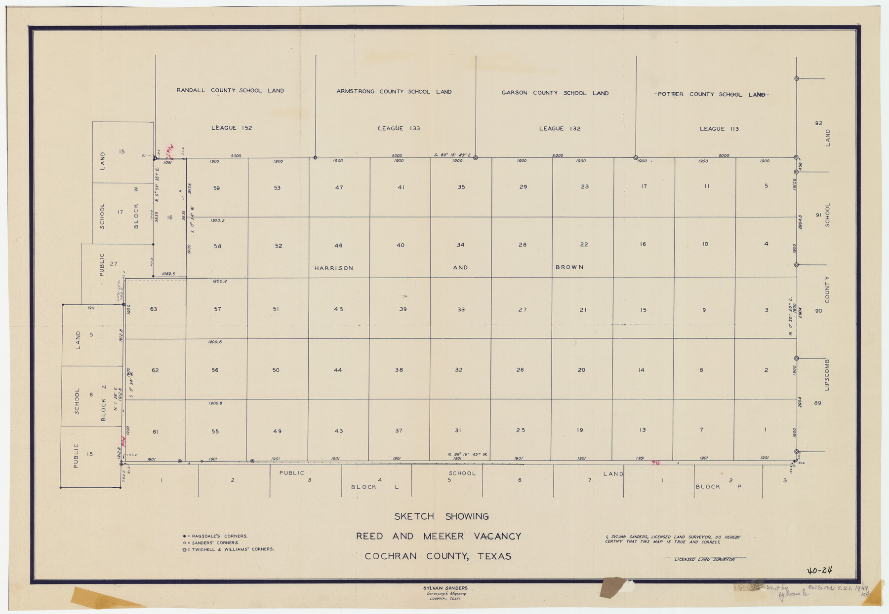
Sketch showing Reed and Meeker Vacancy
40-24
-
Map/Doc
90288
-
Collection
Twichell Survey Records
-
People and Organizations
Sylvan Sanders Surveying and Mapping (Publisher)
-
Counties
Cochran
-
Height x Width
27.9 x 19.3 inches
70.9 x 49.0 cm
Part of: Twichell Survey Records
[Emile Snow Lands and vicinity]
![91147, [Emile Snow Lands and vicinity], Twichell Survey Records](https://historictexasmaps.com/wmedia_w700/maps/91147-1.tif.jpg)
Print $20.00
- Digital $50.00
[Emile Snow Lands and vicinity]
Size 10.7 x 18.9 inches
Map/Doc 91147
[Sketch of Potter County Road, North of River]
![93059, [Sketch of Potter County Road, North of River], Twichell Survey Records](https://historictexasmaps.com/wmedia_w700/maps/93059-1.tif.jpg)
Print $20.00
- Digital $50.00
[Sketch of Potter County Road, North of River]
Size 12.5 x 29.5 inches
Map/Doc 93059
[H. & T. C. 49, Part of G. C. & S. 35, Capitol Leagues 206, 207, 214, 215]
![90688, [H. & T. C. 49, Part of G. C. & S. 35, Capitol Leagues 206, 207, 214, 215], Twichell Survey Records](https://historictexasmaps.com/wmedia_w700/maps/90688-1.tif.jpg)
Print $20.00
- Digital $50.00
[H. & T. C. 49, Part of G. C. & S. 35, Capitol Leagues 206, 207, 214, 215]
1903
Size 13.1 x 13.2 inches
Map/Doc 90688
Sketch Showing Original Corners and Connections Affecting Blocks T1, T2, and T3 in Lamb and Castro Counties, Texas

Print $20.00
- Digital $50.00
Sketch Showing Original Corners and Connections Affecting Blocks T1, T2, and T3 in Lamb and Castro Counties, Texas
Size 17.7 x 30.6 inches
Map/Doc 92199
Sketch in Crockett County, Texas

Print $20.00
- Digital $50.00
Sketch in Crockett County, Texas
1924
Size 34.4 x 47.8 inches
Map/Doc 92606
Eleven County Map

Print $40.00
- Digital $50.00
Eleven County Map
Size 39.2 x 57.5 inches
Map/Doc 89856
![90567, [Block M], Twichell Survey Records](https://historictexasmaps.com/wmedia_w700/maps/90567-1.tif.jpg)
[Strip between Block 8 and Block K4]
![90601, [Strip between Block 8 and Block K4], Twichell Survey Records](https://historictexasmaps.com/wmedia_w700/maps/90601-1.tif.jpg)
Print $2.00
- Digital $50.00
[Strip between Block 8 and Block K4]
Size 8.8 x 11.7 inches
Map/Doc 90601
[T. & P. Block 44, Township 1S]
![90825, [T. & P. Block 44, Township 1S], Twichell Survey Records](https://historictexasmaps.com/wmedia_w700/maps/90825-2.tif.jpg)
Print $20.00
- Digital $50.00
[T. & P. Block 44, Township 1S]
Size 17.9 x 23.3 inches
Map/Doc 90825
Gregg County School Land League 2

Print $20.00
- Digital $50.00
Gregg County School Land League 2
Size 15.6 x 15.5 inches
Map/Doc 90613
Ed Gordon Irrigated Farm NE Quarter Section 14, Block E

Print $20.00
- Digital $50.00
Ed Gordon Irrigated Farm NE Quarter Section 14, Block E
1943
Size 16.0 x 18.6 inches
Map/Doc 92325
[Preliminary Drawing of School Leagues]
![89932, [Preliminary Drawing of School Leagues], Twichell Survey Records](https://historictexasmaps.com/wmedia_w700/maps/89932-1.tif.jpg)
Print $40.00
- Digital $50.00
[Preliminary Drawing of School Leagues]
Size 38.3 x 66.8 inches
Map/Doc 89932
You may also like
Kerr County Rolled Sketch 13

Print $20.00
- Digital $50.00
Kerr County Rolled Sketch 13
1951
Size 23.5 x 30.5 inches
Map/Doc 6498

Hemphill County Rolled Sketch 4

Print $40.00
- Digital $50.00
Hemphill County Rolled Sketch 4
Size 29.7 x 55.1 inches
Map/Doc 6186
Sketch of 103rd Meridian, W. L. showing Conflict of Capitol Leagues

Print $20.00
- Digital $50.00
Sketch of 103rd Meridian, W. L. showing Conflict of Capitol Leagues
Size 8.1 x 22.1 inches
Map/Doc 90578
Cameron County Rolled Sketch 20D

Print $20.00
- Digital $50.00
Cameron County Rolled Sketch 20D
Size 13.7 x 12.1 inches
Map/Doc 5476

Smith County Working Sketch 5

Print $20.00
- Digital $50.00
Smith County Working Sketch 5
1932
Size 32.2 x 22.4 inches
Map/Doc 63890
Brazoria County Sketch File 26

Print $40.00
- Digital $50.00
Brazoria County Sketch File 26
Size 13.6 x 13.6 inches
Map/Doc 15028
General Highway Map, Nolan County, Texas

Print $20.00
General Highway Map, Nolan County, Texas
1940
Size 18.4 x 24.7 inches
Map/Doc 79208
Flight Mission No. CGI-3N, Frame 130, Cameron County

Print $20.00
- Digital $50.00
Flight Mission No. CGI-3N, Frame 130, Cameron County
1954
Size 18.5 x 22.2 inches
Map/Doc 84603
Pecos County Rolled Sketch 90

Print $20.00
- Digital $50.00
Pecos County Rolled Sketch 90
1934
Size 26.7 x 33.9 inches
Map/Doc 7245
Starr County Rolled Sketch 41

Print $6.00
- Digital $50.00
Starr County Rolled Sketch 41
1971
Size 10.8 x 15.8 inches
Map/Doc 49030