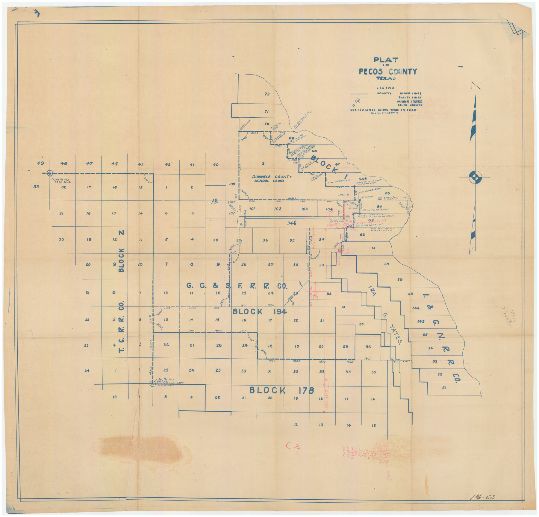
Plat in Pecos County, Texas
186-62
-
Map/Doc
89834
-
Collection
Twichell Survey Records
-
Counties
Pecos
-
Height x Width
38.7 x 37.5 inches
98.3 x 95.3 cm
Part of: Twichell Survey Records
Map Showing the Jo Dick Slaughter Lands in Dawson, Martin, Borden, and Howard Counties, Texas

Print $20.00
- Digital $50.00
Map Showing the Jo Dick Slaughter Lands in Dawson, Martin, Borden, and Howard Counties, Texas
Size 26.6 x 20.8 inches
Map/Doc 92506
[Sketch showing B. S. & F. survey number 9, section 9]
![91711, [Sketch showing B. S. & F. survey number 9, section 9], Twichell Survey Records](https://historictexasmaps.com/wmedia_w700/maps/91711-1.tif.jpg)
Print $2.00
- Digital $50.00
[Sketch showing B. S. & F. survey number 9, section 9]
Size 8.7 x 8.1 inches
Map/Doc 91711
[H. & T. C. 47, Sections 57- 61] / [Blocks 4 and 6]
![91416, [H. & T. C. 47, Sections 57- 61] / [Blocks 4 and 6], Twichell Survey Records](https://historictexasmaps.com/wmedia_w700/maps/91416-1.tif.jpg)
Print $20.00
- Digital $50.00
[H. & T. C. 47, Sections 57- 61] / [Blocks 4 and 6]
Size 26.0 x 19.5 inches
Map/Doc 91416
[Sketch N, showing H. & G. N. Block 7, and Blocks C-1 through C-5]
![91768, [Sketch N, showing H. & G. N. Block 7, and Blocks C-1 through C-5], Twichell Survey Records](https://historictexasmaps.com/wmedia_w700/maps/91768-1.tif.jpg)
Print $20.00
- Digital $50.00
[Sketch N, showing H. & G. N. Block 7, and Blocks C-1 through C-5]
Size 14.6 x 16.7 inches
Map/Doc 91768
[Leagues 464-467 and vicinity]
![91559, [Leagues 464-467 and vicinity], Twichell Survey Records](https://historictexasmaps.com/wmedia_w700/maps/91559-1.tif.jpg)
Print $20.00
- Digital $50.00
[Leagues 464-467 and vicinity]
Size 18.4 x 12.1 inches
Map/Doc 91559
General Highway Map Cochran County, Texas

Print $20.00
- Digital $50.00
General Highway Map Cochran County, Texas
1948
Size 18.7 x 25.6 inches
Map/Doc 92498
![91538, [Block 3T], Twichell Survey Records](https://historictexasmaps.com/wmedia_w700/maps/91538-1.tif.jpg)
C B Live Stock Co.'s West-Ranch

Print $2.00
- Digital $50.00
C B Live Stock Co.'s West-Ranch
Size 6.4 x 8.6 inches
Map/Doc 90178
[Canadian River and surveys north]
![91780, [Canadian River and surveys north], Twichell Survey Records](https://historictexasmaps.com/wmedia_w700/maps/91780-1.tif.jpg)
Print $20.00
- Digital $50.00
[Canadian River and surveys north]
Size 38.3 x 21.6 inches
Map/Doc 91780
General Highway Map of Garza County, Texas

Print $20.00
- Digital $50.00
General Highway Map of Garza County, Texas
1950
Size 25.9 x 18.8 inches
Map/Doc 92646
Map of N. W. Portion Blk G. Gaines Co.

Print $20.00
- Digital $50.00
Map of N. W. Portion Blk G. Gaines Co.
1914
Size 37.4 x 26.7 inches
Map/Doc 90867
Dawson County Sketch

Print $20.00
- Digital $50.00
Dawson County Sketch
Size 37.0 x 20.5 inches
Map/Doc 92628
You may also like
Dimmit County Boundary File 8

Print $48.00
- Digital $50.00
Dimmit County Boundary File 8
Size 7.2 x 37.2 inches
Map/Doc 52597
Matagorda Light to Aransas Pass

Print $20.00
- Digital $50.00
Matagorda Light to Aransas Pass
1985
Size 36.8 x 44.8 inches
Map/Doc 73403
Dickens County Sketch File 22

Print $8.00
- Digital $50.00
Dickens County Sketch File 22
1913
Size 11.2 x 9.1 inches
Map/Doc 20985
Bee County Boundary File 4

Print $22.00
- Digital $50.00
Bee County Boundary File 4
Size 12.9 x 8.1 inches
Map/Doc 50441
Presidio County Sketch File 65

Print $6.00
- Digital $50.00
Presidio County Sketch File 65
1940
Size 11.0 x 15.3 inches
Map/Doc 34654
Wise County Sketch File 39

Print $4.00
- Digital $50.00
Wise County Sketch File 39
1860
Size 9.3 x 8.1 inches
Map/Doc 40595
Louisiana and Texas Intracoastal Waterway

Print $20.00
- Digital $50.00
Louisiana and Texas Intracoastal Waterway
1939
Size 14.0 x 19.6 inches
Map/Doc 83346

Trinity River, Balltown Sheet/Pilot Grove Creek

Print $20.00
- Digital $50.00
Trinity River, Balltown Sheet/Pilot Grove Creek
1938
Size 40.1 x 33.7 inches
Map/Doc 65196
[H. & G. N. Block 8 showing Llano and Espuella fence lines]
![90375, [H. & G. N. Block 8 showing Llano and Espuella fence lines], Twichell Survey Records](https://historictexasmaps.com/wmedia_w700/maps/90375-1.tif.jpg)
Print $2.00
- Digital $50.00
[H. & G. N. Block 8 showing Llano and Espuella fence lines]
Size 8.7 x 11.0 inches
Map/Doc 90375
Flight Mission No. DCL-7C, Frame 112, Kenedy County

Print $20.00
- Digital $50.00
Flight Mission No. DCL-7C, Frame 112, Kenedy County
1943
Size 18.5 x 22.2 inches
Map/Doc 86077
[Gulf, Colorado & Santa Fe]
![64590, [Gulf, Colorado & Santa Fe], General Map Collection](https://historictexasmaps.com/wmedia_w700/maps/64590.tif.jpg)
Print $40.00
- Digital $50.00
[Gulf, Colorado & Santa Fe]
1918
Size 31.4 x 117.0 inches
Map/Doc 64590