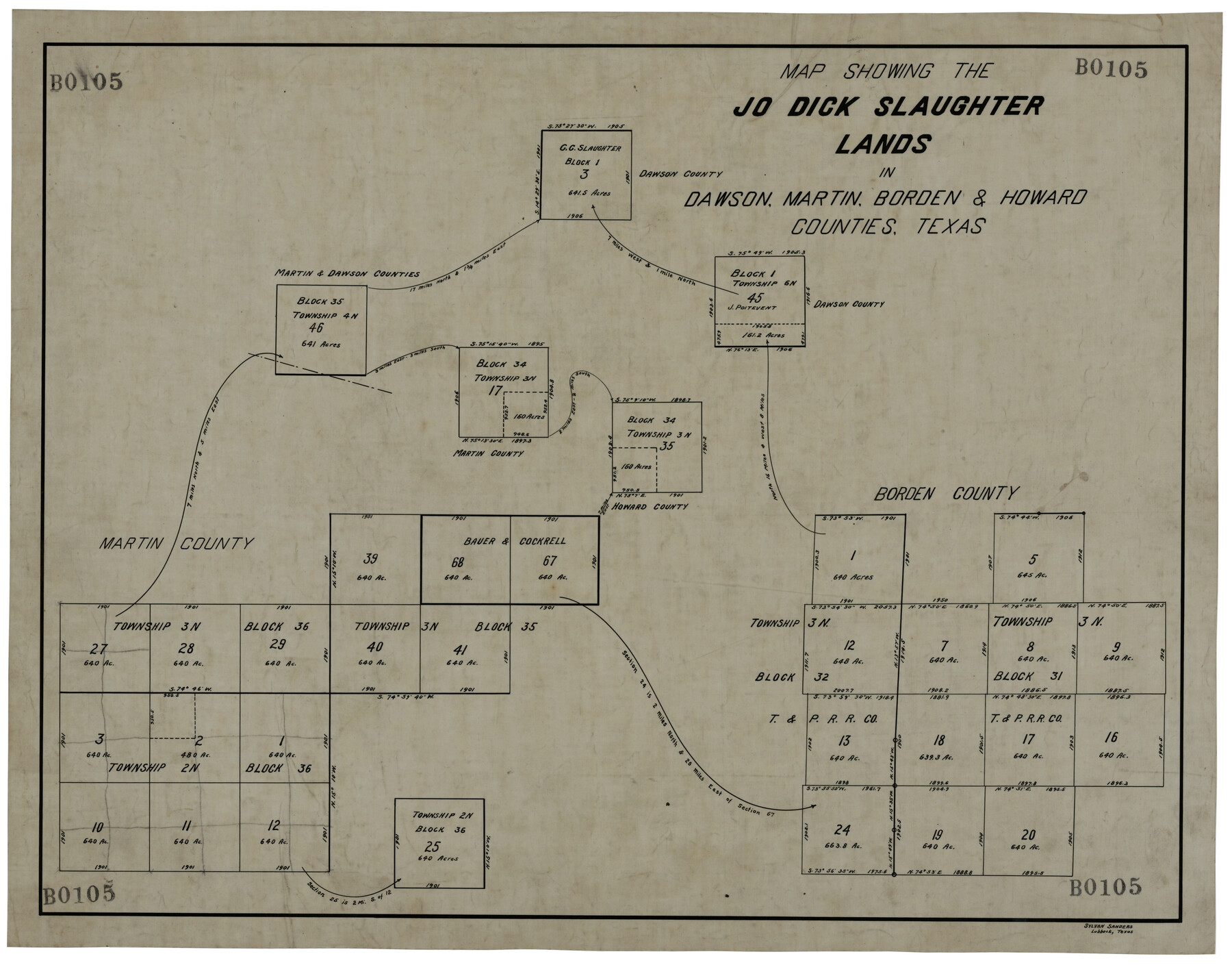
Map Showing the Jo Dick Slaughter Lands in Dawson, Martin, Borden, and Howard Counties, Texas
BO105
-
Map/Doc
92506
-
Collection
Twichell Survey Records
-
People and Organizations
Sylvan Sanders (Surveyor/Engineer)
-
Counties
Borden Dawson Howard Martin
-
Height x Width
26.6 x 20.8 inches
67.6 x 52.8 cm
Part of: Twichell Survey Records
Map B [showing surveys along river and in vicinity of Archer County School Land League 3]
![89752, Map B [showing surveys along river and in vicinity of Archer County School Land League 3], Twichell Survey Records](https://historictexasmaps.com/wmedia_w700/maps/89752-1.tif.jpg)
Print $20.00
- Digital $50.00
Map B [showing surveys along river and in vicinity of Archer County School Land League 3]
Size 42.7 x 38.0 inches
Map/Doc 89752
[Scripture Addition to the City of Denton]
![90586, [Scripture Addition to the City of Denton], Twichell Survey Records](https://historictexasmaps.com/wmedia_w700/maps/90586-1.tif.jpg)
Print $20.00
- Digital $50.00
[Scripture Addition to the City of Denton]
Size 35.4 x 31.4 inches
Map/Doc 90586
[T. & P. Block 44, Township 1S]
![90893, [T. & P. Block 44, Township 1S], Twichell Survey Records](https://historictexasmaps.com/wmedia_w700/maps/90893-1.tif.jpg)
Print $20.00
- Digital $50.00
[T. & P. Block 44, Township 1S]
Size 21.5 x 10.1 inches
Map/Doc 90893
Mrs. Don D. Kinnebrew Farm Section 72, Block A

Print $20.00
- Digital $50.00
Mrs. Don D. Kinnebrew Farm Section 72, Block A
Size 15.6 x 18.0 inches
Map/Doc 92290
O'Neall Terrace, a Re-Subdivision of Blocks 37-38-39-40-43-44-45-46-110-112-113-114 and Parts of Blocks 111 and 115, McCrummens Second Addition to the City of Lubbock, Texas

Print $20.00
- Digital $50.00
O'Neall Terrace, a Re-Subdivision of Blocks 37-38-39-40-43-44-45-46-110-112-113-114 and Parts of Blocks 111 and 115, McCrummens Second Addition to the City of Lubbock, Texas
Size 22.6 x 27.5 inches
Map/Doc 92743
[Block B9 and 3KA]
![90483, [Block B9 and 3KA], Twichell Survey Records](https://historictexasmaps.com/wmedia_w700/maps/90483-1.tif.jpg)
Print $20.00
- Digital $50.00
[Block B9 and 3KA]
Size 23.6 x 16.3 inches
Map/Doc 90483
[H. & T. C. 49, Part of G. C. & S. 35, Capitol Leagues 206, 207, 214, 215]
![90688, [H. & T. C. 49, Part of G. C. & S. 35, Capitol Leagues 206, 207, 214, 215], Twichell Survey Records](https://historictexasmaps.com/wmedia_w700/maps/90688-1.tif.jpg)
Print $20.00
- Digital $50.00
[H. & T. C. 49, Part of G. C. & S. 35, Capitol Leagues 206, 207, 214, 215]
1903
Size 13.1 x 13.2 inches
Map/Doc 90688
[Block 47, Sections 66-76]
![91790, [Block 47, Sections 66-76], Twichell Survey Records](https://historictexasmaps.com/wmedia_w700/maps/91790-1.tif.jpg)
Print $3.00
- Digital $50.00
[Block 47, Sections 66-76]
Size 15.8 x 10.6 inches
Map/Doc 91790
C. B. Livestock Co.'s West-Ranch, Bailey County, Texas

Print $3.00
- Digital $50.00
C. B. Livestock Co.'s West-Ranch, Bailey County, Texas
Size 16.9 x 11.5 inches
Map/Doc 90384
Richard's Addition to Adrian, Situated in Oldham County, Texas

Print $20.00
- Digital $50.00
Richard's Addition to Adrian, Situated in Oldham County, Texas
Size 21.4 x 24.3 inches
Map/Doc 91428
Robertson & Scott V Ranch situated in Crosby County, Texas

Print $40.00
- Digital $50.00
Robertson & Scott V Ranch situated in Crosby County, Texas
Size 42.0 x 50.3 inches
Map/Doc 89753
G. T. Oliver's Subdivisions of the Motley and Foard County School Leagues situated in Bailey County, Texas

Print $20.00
- Digital $50.00
G. T. Oliver's Subdivisions of the Motley and Foard County School Leagues situated in Bailey County, Texas
1909
Size 24.6 x 37.4 inches
Map/Doc 92534
You may also like
Webb County Working Sketch 19

Print $20.00
- Digital $50.00
Webb County Working Sketch 19
1925
Size 32.6 x 29.8 inches
Map/Doc 72384
Young County Sketch File 7

Print $6.00
- Digital $50.00
Young County Sketch File 7
1856
Size 8.4 x 9.2 inches
Map/Doc 40859
Harris County Working Sketch 121

Print $20.00
- Digital $50.00
Harris County Working Sketch 121
1985
Size 34.4 x 18.6 inches
Map/Doc 66013
Township 12 South Range 14 West and 15 West, South Western District, Louisiana

Print $20.00
- Digital $50.00
Township 12 South Range 14 West and 15 West, South Western District, Louisiana
1838
Size 19.5 x 24.5 inches
Map/Doc 65856
Transcribed English Field Notes from Austin's Colonies and Transcribed Spanish Titles from Robertson's Colony, 1825-1835

Transcribed English Field Notes from Austin's Colonies and Transcribed Spanish Titles from Robertson's Colony, 1825-1835
1825
Size 17.0 x 12.1 inches
Map/Doc 94532
Right of Way and Track Map, International & Gt. Northern Ry. Operated by the International & Gt. Northern Ry. Co., Gulf Division

Print $40.00
- Digital $50.00
Right of Way and Track Map, International & Gt. Northern Ry. Operated by the International & Gt. Northern Ry. Co., Gulf Division
1917
Size 24.8 x 56.5 inches
Map/Doc 64251
Amistad International Reservoir on Rio Grande 109

Print $20.00
- Digital $50.00
Amistad International Reservoir on Rio Grande 109
1950
Size 28.6 x 41.3 inches
Map/Doc 75540
Presidio County Rolled Sketch 97

Print $20.00
- Digital $50.00
Presidio County Rolled Sketch 97
1952
Size 32.0 x 35.5 inches
Map/Doc 9783
Texas Gulf Coast from the Sabine River to the Rio Grande Showing Subdivision for Mineral Development.

Print $40.00
- Digital $50.00
Texas Gulf Coast from the Sabine River to the Rio Grande Showing Subdivision for Mineral Development.
1958
Size 46.5 x 118.6 inches
Map/Doc 2944
[Township 2 North, Blocks 32 and 33]
![91212, [Township 2 North, Blocks 32 and 33], Twichell Survey Records](https://historictexasmaps.com/wmedia_w700/maps/91212-1.tif.jpg)
Print $3.00
- Digital $50.00
[Township 2 North, Blocks 32 and 33]
Size 11.8 x 10.8 inches
Map/Doc 91212
Blanco County Working Sketch 42

Print $20.00
- Digital $50.00
Blanco County Working Sketch 42
1986
Size 35.1 x 30.7 inches
Map/Doc 67402
Culberson County Working Sketch 84

Print $20.00
- Digital $50.00
Culberson County Working Sketch 84
1980
Size 43.5 x 42.9 inches
Map/Doc 68538