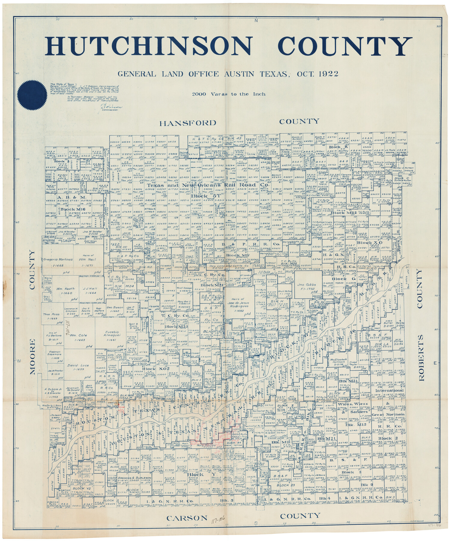
Hutchinson County, 1922
117-106
-
Map/Doc
89700
-
Collection
Twichell Survey Records
-
Object Dates
1922 (Creation Date)
-
Counties
Hutchinson
-
Subjects
County
-
Height x Width
36.4 x 43.7 inches
92.5 x 111.0 cm
Part of: Twichell Survey Records
Southeast Corner of Gray County

Print $20.00
- Digital $50.00
Southeast Corner of Gray County
1882
Size 18.8 x 22.6 inches
Map/Doc 90757
[West Half of the State of Kansas]
![93159, [West Half of the State of Kansas], Twichell Survey Records](https://historictexasmaps.com/wmedia_w700/maps/93159-1.tif.jpg)
Print $40.00
- Digital $50.00
[West Half of the State of Kansas]
Size 60.8 x 54.0 inches
Map/Doc 93159
[Canadian River and surveys north]
![91780, [Canadian River and surveys north], Twichell Survey Records](https://historictexasmaps.com/wmedia_w700/maps/91780-1.tif.jpg)
Print $20.00
- Digital $50.00
[Canadian River and surveys north]
Size 38.3 x 21.6 inches
Map/Doc 91780
![91447, [Block K5], Twichell Survey Records](https://historictexasmaps.com/wmedia_w700/maps/91447-1.tif.jpg)
[Sketch of all of County]
![89972, [Sketch of all of County], Twichell Survey Records](https://historictexasmaps.com/wmedia_w700/maps/89972-1.tif.jpg)
Print $40.00
- Digital $50.00
[Sketch of all of County]
Size 71.0 x 44.3 inches
Map/Doc 89972
[Map showing J. H. Gibson Blocks D and DD]
![92006, [Map showing J. H. Gibson Blocks D and DD], Twichell Survey Records](https://historictexasmaps.com/wmedia_w700/maps/92006-1.tif.jpg)
Print $20.00
- Digital $50.00
[Map showing J. H. Gibson Blocks D and DD]
Size 31.5 x 22.0 inches
Map/Doc 92006
Parts of Garza and Lynn Counties

Print $20.00
- Digital $50.00
Parts of Garza and Lynn Counties
1925
Size 23.1 x 17.0 inches
Map/Doc 91341
[Sketch showing B. S. & F. Block 9]
![91743, [Sketch showing B. S. & F. Block 9], Twichell Survey Records](https://historictexasmaps.com/wmedia_w700/maps/91743-1.tif.jpg)
Print $20.00
- Digital $50.00
[Sketch showing B. S. & F. Block 9]
Size 25.1 x 34.1 inches
Map/Doc 91743

Terry County Memorial Cemetery

Print $20.00
- Digital $50.00
Terry County Memorial Cemetery
Size 35.3 x 14.4 inches
Map/Doc 92931
Levelland Independent School District Hockley County, Texas

Print $20.00
- Digital $50.00
Levelland Independent School District Hockley County, Texas
Size 36.2 x 29.8 inches
Map/Doc 92240
[Midland County School Land, Martin County School Land, and vicinity]
![91128, [Midland County School Land, Martin County School Land, and vicinity], Twichell Survey Records](https://historictexasmaps.com/wmedia_w700/maps/91128-1.tif.jpg)
Print $2.00
- Digital $50.00
[Midland County School Land, Martin County School Land, and vicinity]
Size 9.0 x 11.4 inches
Map/Doc 91128
You may also like
Tarrant County Sketch File 20

Print $4.00
- Digital $50.00
Tarrant County Sketch File 20
1857
Size 7.0 x 7.3 inches
Map/Doc 37723
Presidio County Sketch File 75

Print $30.00
- Digital $50.00
Presidio County Sketch File 75
1946
Size 8.9 x 14.3 inches
Map/Doc 34691
Right of Way and Track Map Houston & Texas Central R.R. operated by the T. and N. O. R.R. Co., Fort Worth Branch

Print $40.00
- Digital $50.00
Right of Way and Track Map Houston & Texas Central R.R. operated by the T. and N. O. R.R. Co., Fort Worth Branch
1918
Size 31.1 x 57.4 inches
Map/Doc 64540
Flight Mission No. BRA-7M, Frame 86, Jefferson County

Print $20.00
- Digital $50.00
Flight Mission No. BRA-7M, Frame 86, Jefferson County
1953
Size 18.7 x 22.4 inches
Map/Doc 85508

Part of City of Plains

Print $20.00
- Digital $50.00
Part of City of Plains
Size 37.1 x 23.6 inches
Map/Doc 92449
Clay County Sketch File 16

Print $9.00
- Digital $50.00
Clay County Sketch File 16
1874
Size 8.3 x 7.9 inches
Map/Doc 18421
Presidio County Sketch File 28A

Print $20.00
- Digital $50.00
Presidio County Sketch File 28A
1890
Size 16.3 x 17.9 inches
Map/Doc 11710
Galveston County Rolled Sketch WF

Print $20.00
- Digital $50.00
Galveston County Rolled Sketch WF
Size 25.2 x 34.1 inches
Map/Doc 5991
Duval County Sketch File 41

Print $20.00
- Digital $50.00
Duval County Sketch File 41
1936
Size 19.6 x 17.2 inches
Map/Doc 11397
The Peters Colony. January 20, 1843

Print $20.00
The Peters Colony. January 20, 1843
2020
Size 17.2 x 21.7 inches
Map/Doc 96365
Flight Mission No. DAH-17M, Frame 18, Orange County

Print $20.00
- Digital $50.00
Flight Mission No. DAH-17M, Frame 18, Orange County
1953
Size 18.5 x 22.6 inches
Map/Doc 86881