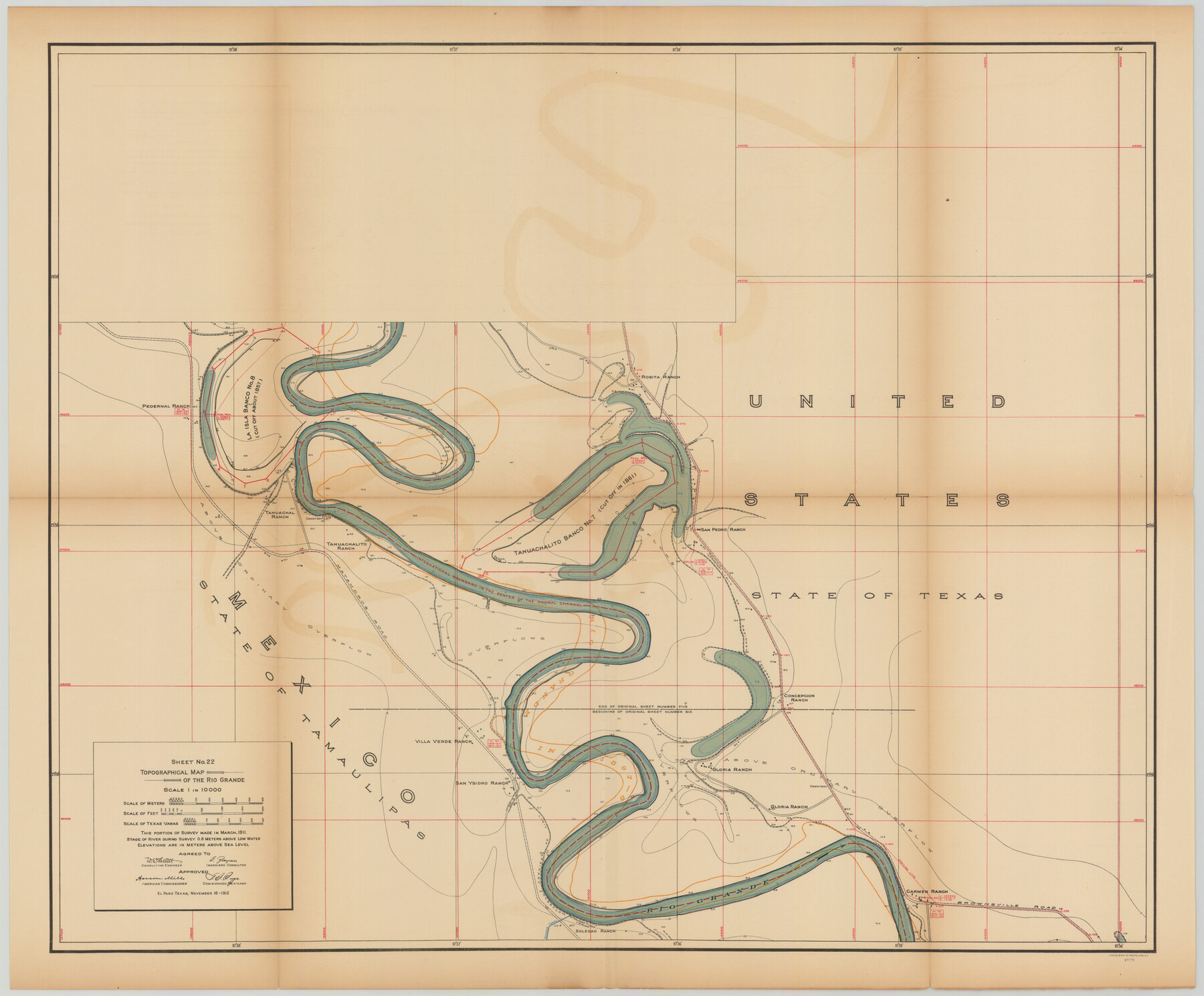
Topographical Map of the Rio Grande, Sheet No. 22
[from book: "Survey of the Rio Grande, Roma to the Gulf of Mexico, Reports and Maps"]
-
Map/Doc
89546
-
Collection
General Map Collection
-
Object Dates
1912/11/16 (Creation Date)
-
People and Organizations
International Boundary Commission (Publisher)
Anson Mills (Author)
E. Zayas (Surveyor/Engineer)
F.B. Puga (Author)
W.W. Follett (Surveyor/Engineer)
-
Subjects
River Surveys Texas Boundaries Topographic
-
Medium
paper
-
Scale
1:10000
-
Comments
This portion of the survey made in March, 1911. State of river during survey 0.8 meters above low water. Elevations are in meters above sea level. This map and 31 others were originally folded and bound into a book titled "Survey of the Rio Grande, R
Part of: General Map Collection

Grayson County Working Sketch 13

Print $20.00
- Digital $50.00
Grayson County Working Sketch 13
1952
Size 31.1 x 38.0 inches
Map/Doc 63252
Coke County Rolled Sketch 33

Print $20.00
- Digital $50.00
Coke County Rolled Sketch 33
2004
Size 28.9 x 40.5 inches
Map/Doc 82987
Refugio County NRC Article 33.136 Location Key Sheet

Print $20.00
- Digital $50.00
Refugio County NRC Article 33.136 Location Key Sheet
1979
Size 27.0 x 23.0 inches
Map/Doc 77034
Llano County Sketch File 4

Print $6.00
- Digital $50.00
Llano County Sketch File 4
1869
Size 12.4 x 8.0 inches
Map/Doc 30353
Culberson County Sketch File 38

Print $20.00
- Digital $50.00
Culberson County Sketch File 38
1964
Size 21.7 x 18.6 inches
Map/Doc 11274
Hutchinson County Working Sketch 48

Print $20.00
- Digital $50.00
Hutchinson County Working Sketch 48
1981
Size 36.7 x 29.5 inches
Map/Doc 66408
Hemphill County Working Sketch 20

Print $20.00
- Digital $50.00
Hemphill County Working Sketch 20
1972
Size 34.9 x 47.1 inches
Map/Doc 66115
Marion County Working Sketch 12

Print $20.00
- Digital $50.00
Marion County Working Sketch 12
1952
Size 24.5 x 34.2 inches
Map/Doc 70787

[Sketch for Mineral Application 33721 - 33725 Incl. - Padre and Mustang Island]
![2879, [Sketch for Mineral Application 33721 - 33725 Incl. - Padre and Mustang Island], General Map Collection](https://historictexasmaps.com/wmedia_w700/maps/2879.tif.jpg)
Print $20.00
- Digital $50.00
[Sketch for Mineral Application 33721 - 33725 Incl. - Padre and Mustang Island]
1942
Size 29.4 x 22.2 inches
Map/Doc 2879
Galveston County NRC Article 33.136 Sketch 25

Print $26.00
- Digital $50.00
Galveston County NRC Article 33.136 Sketch 25
1999
Size 36.0 x 23.9 inches
Map/Doc 81906
You may also like
J. F. Kelley Farm

Print $20.00
- Digital $50.00
J. F. Kelley Farm
Size 16.3 x 19.5 inches
Map/Doc 92408
Taylor County Rolled Sketch 30A

Print $20.00
- Digital $50.00
Taylor County Rolled Sketch 30A
Size 17.5 x 11.3 inches
Map/Doc 76410
Ellwood Farms Subdivision Number 2 of the Spade Ranch Lamb and Hale Counties, Texas

Print $20.00
- Digital $50.00
Ellwood Farms Subdivision Number 2 of the Spade Ranch Lamb and Hale Counties, Texas
Size 20.9 x 29.1 inches
Map/Doc 92173
Palo Pinto County Sketch File 23

Print $20.00
- Digital $50.00
Palo Pinto County Sketch File 23
1949
Size 23.5 x 15.4 inches
Map/Doc 12135
Travis County Sketch File 18

Print $20.00
- Digital $50.00
Travis County Sketch File 18
1872
Size 24.2 x 25.4 inches
Map/Doc 12458
Flight Mission No. CRC-4R, Frame 71, Chambers County

Print $20.00
- Digital $50.00
Flight Mission No. CRC-4R, Frame 71, Chambers County
1956
Size 18.7 x 22.5 inches
Map/Doc 84875
Lipscomb County Rolled Sketch 1

Print $40.00
- Digital $50.00
Lipscomb County Rolled Sketch 1
Size 65.0 x 15.8 inches
Map/Doc 9449
Hansford County, Texas

Print $20.00
- Digital $50.00
Hansford County, Texas
1880
Size 19.9 x 18.9 inches
Map/Doc 528
Montgomery County Sketch File 2

Print $8.00
- Digital $50.00
Montgomery County Sketch File 2
1846
Size 12.7 x 8.0 inches
Map/Doc 31764
[Sketch showing B. S. & F. survey number 9, section 9]
![91711, [Sketch showing B. S. & F. survey number 9, section 9], Twichell Survey Records](https://historictexasmaps.com/wmedia_w700/maps/91711-1.tif.jpg)
Print $2.00
- Digital $50.00
[Sketch showing B. S. & F. survey number 9, section 9]
Size 8.7 x 8.1 inches
Map/Doc 91711
Liberty County Working Sketch 83

Print $40.00
- Digital $50.00
Liberty County Working Sketch 83
1981
Size 68.4 x 37.8 inches
Map/Doc 70543
Zavala County Sketch File 33

Print $7.00
- Digital $50.00
Zavala County Sketch File 33
1886
Size 10.9 x 8.3 inches
Map/Doc 41392