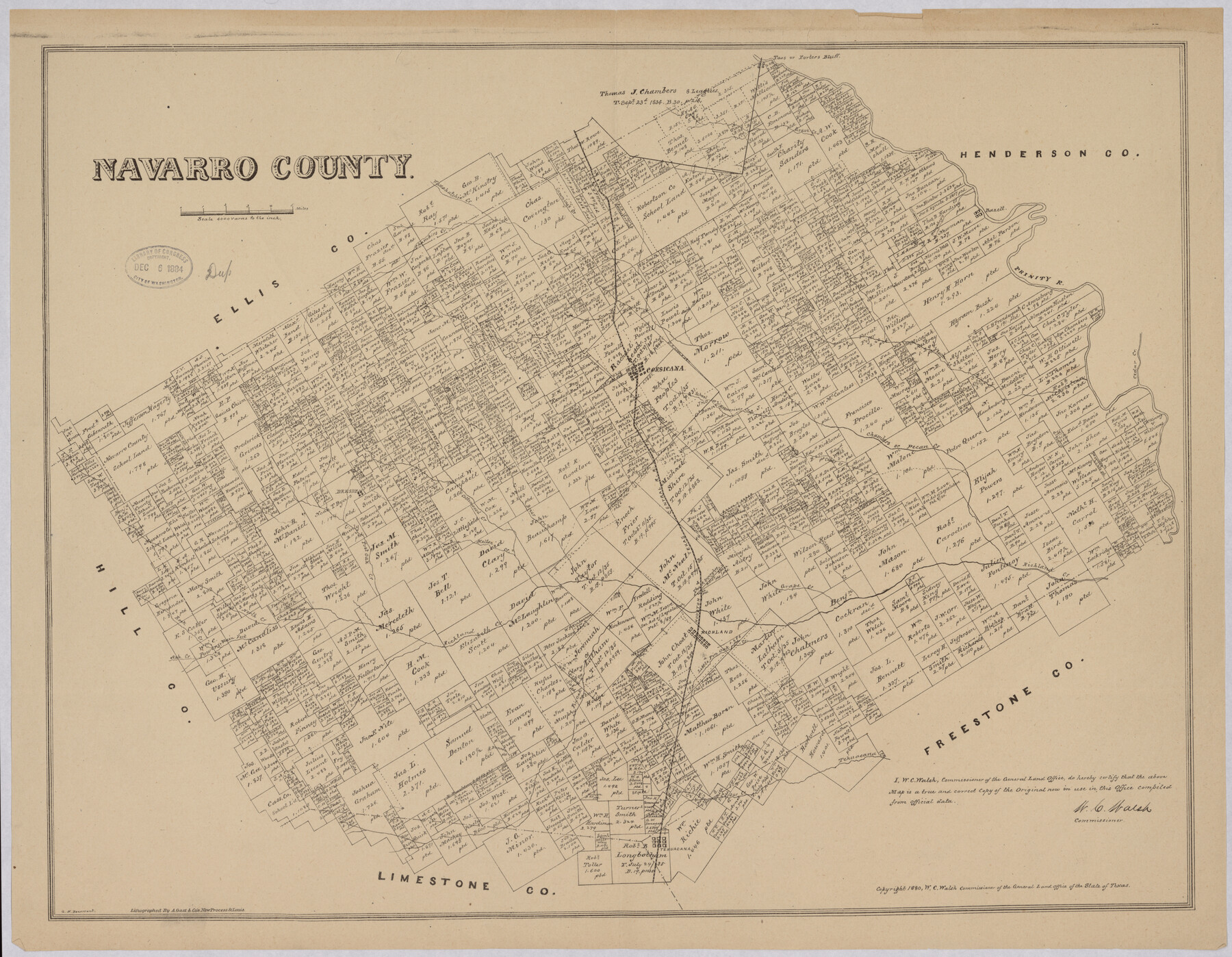
Navarro County
-
Map/Doc
88983
-
Collection
Library of Congress
-
Object Dates
1880 (Creation Date)
-
People and Organizations
General Land Office (Publisher)
W.C. Walsh (GLO Commissioner)
G.N. Beaumont (Draftsman)
August Gast & Co. (Lithographer)
-
Counties
Navarro
-
Subjects
County
-
Height x Width
20.5 x 26.4 inches
52.1 x 67.1 cm
-
Comments
Prints available from the GLO courtesy of Library of Congress, Geography and Map Division.
Part of: Library of Congress
[Map showing T&P Lands in El Paso County]
![88938, [Map showing T&P Lands in El Paso County], Library of Congress](https://historictexasmaps.com/wmedia_w700/maps/88938.tif.jpg)
Print $20.00
[Map showing T&P Lands in El Paso County]
Size 22.4 x 17.2 inches
Map/Doc 88938
Dallas, Texas. With the Projected River and Navigation Improvements. Viewed from Above the Sister City of Oak Cliff

Print $20.00
Dallas, Texas. With the Projected River and Navigation Improvements. Viewed from Above the Sister City of Oak Cliff
1892
Size 20.9 x 29.7 inches
Map/Doc 93474
[Map showing T&P Lands in El Paso County]
![88934, [Map showing T&P Lands in El Paso County], Library of Congress](https://historictexasmaps.com/wmedia_w700/maps/88934.tif.jpg)
Print $20.00
[Map showing T&P Lands in El Paso County]
Size 17.3 x 22.2 inches
Map/Doc 88934
Map of Texas With Parts of the Adjoining States

Print $20.00
Map of Texas With Parts of the Adjoining States
1839
Size 35.4 x 25.8 inches
Map/Doc 88995
Mapa topográfico de la provincia de Texas

Print $20.00
Mapa topográfico de la provincia de Texas
1822
Size 10.2 x 13.9 inches
Map/Doc 89228
[Map showing T&P Lands in El Paso County]
![88937, [Map showing T&P Lands in El Paso County], Library of Congress](https://historictexasmaps.com/wmedia_w700/maps/88937.tif.jpg)
Print $20.00
[Map showing T&P Lands in El Paso County]
Size 22.3 x 17.3 inches
Map/Doc 88937
![88993, San Jacinto Co[unty], Library of Congress](https://historictexasmaps.com/wmedia_w700/maps/88993.tif.jpg)

[Map showing T&P Lands in El Paso County]
![88933, [Map showing T&P Lands in El Paso County], Library of Congress](https://historictexasmaps.com/wmedia_w700/maps/88933.tif.jpg)
Print $20.00
[Map showing T&P Lands in El Paso County]
Size 17.2 x 22.1 inches
Map/Doc 88933
[Map of T&P Blocks 1 and 2 in Jeff Davis and Presidio Counties]
![88959, [Map of T&P Blocks 1 and 2 in Jeff Davis and Presidio Counties], Library of Congress](https://historictexasmaps.com/wmedia_w700/maps/88959.tif.jpg)
Print $20.00
[Map of T&P Blocks 1 and 2 in Jeff Davis and Presidio Counties]
Size 22.2 x 17.3 inches
Map/Doc 88959
Map of the County of Galveston

Print $20.00
Map of the County of Galveston
1902
Size 18.5 x 26.4 inches
Map/Doc 93584
Colton's United States shewing the military stations, forts, &c

Print $20.00
Colton's United States shewing the military stations, forts, &c
1861
Size 14.6 x 17.3 inches
Map/Doc 93565
You may also like
Refugio County NRC Article 33.136 Location Key Sheet

Print $20.00
- Digital $50.00
Refugio County NRC Article 33.136 Location Key Sheet
Size 26.3 x 22.3 inches
Map/Doc 87912
Webb County Rolled Sketch 57

Print $20.00
- Digital $50.00
Webb County Rolled Sketch 57
Size 23.5 x 32.2 inches
Map/Doc 8209
Colorado County Working Sketch 13

Print $20.00
- Digital $50.00
Colorado County Working Sketch 13
1943
Size 37.9 x 23.3 inches
Map/Doc 68113
Texas-Indian Territory Denison Quadrangle

Print $20.00
- Digital $50.00
Texas-Indian Territory Denison Quadrangle
1901
Size 20.1 x 16.7 inches
Map/Doc 75110
Uvalde County Sketch File 24

Print $42.00
- Digital $50.00
Uvalde County Sketch File 24
1926
Size 19.4 x 29.9 inches
Map/Doc 12536
Knox County Rolled Sketch 7

Print $20.00
- Digital $50.00
Knox County Rolled Sketch 7
Size 25.5 x 39.9 inches
Map/Doc 6556
Webb County Working Sketch 2

Print $20.00
- Digital $50.00
Webb County Working Sketch 2
1906
Size 11.2 x 12.5 inches
Map/Doc 72367
Aransas County Working Sketch 6

Print $20.00
- Digital $50.00
Aransas County Working Sketch 6
1943
Size 26.0 x 35.5 inches
Map/Doc 67173
Ector County Working Sketch 29

Print $40.00
- Digital $50.00
Ector County Working Sketch 29
1971
Size 43.9 x 63.4 inches
Map/Doc 68872
Kent County Working Sketch 7

Print $20.00
- Digital $50.00
Kent County Working Sketch 7
1952
Size 32.7 x 23.7 inches
Map/Doc 70014
Brewster County Rolled Sketch 146B

Print $40.00
- Digital $50.00
Brewster County Rolled Sketch 146B
1985
Size 55.5 x 45.2 inches
Map/Doc 8528
Hemphill County Sketch File 7

Print $20.00
- Digital $50.00
Hemphill County Sketch File 7
1924
Size 18.5 x 20.4 inches
Map/Doc 11753