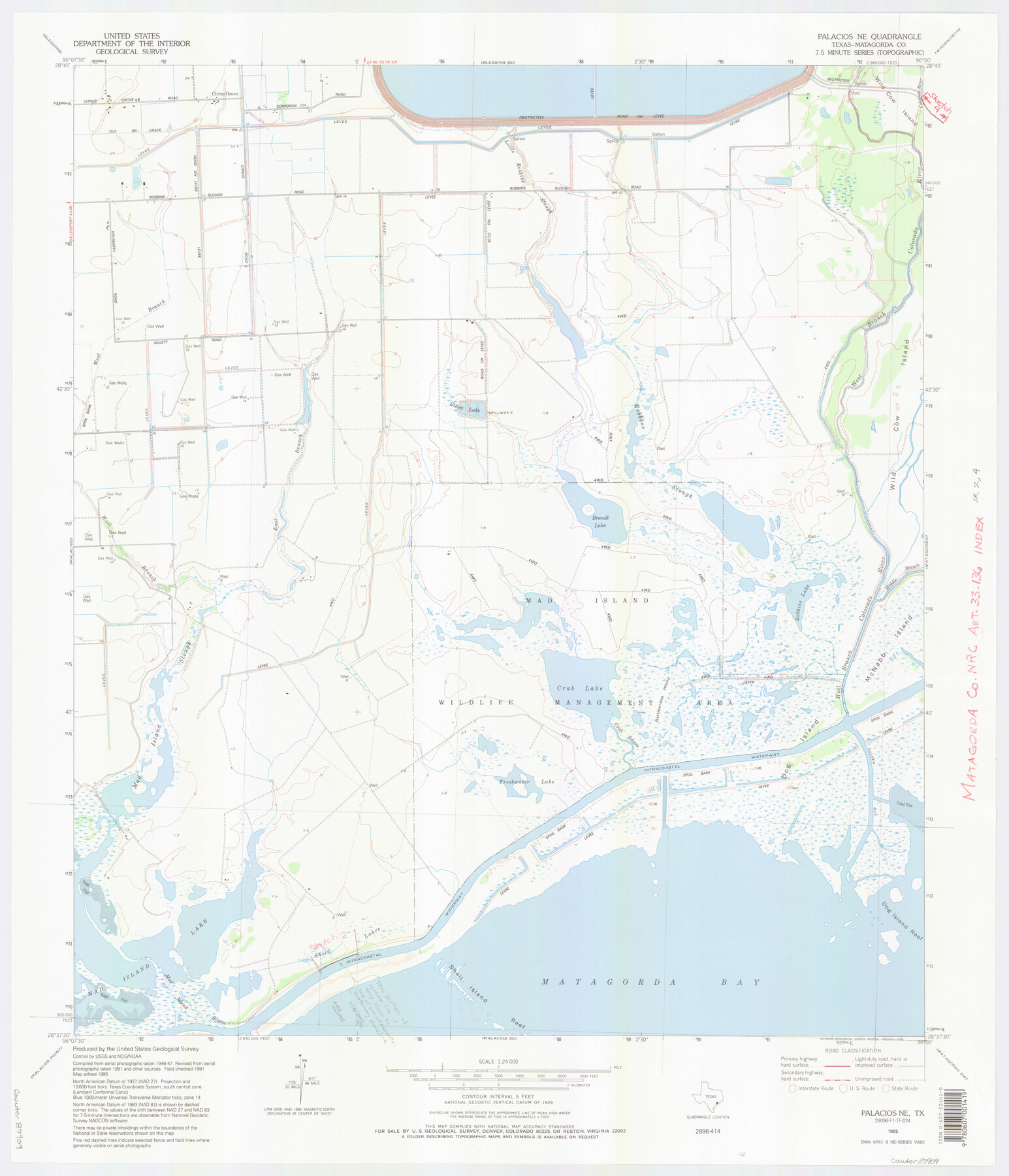
Matagorda County NRC Article 33.136 Location Key Sheet
Palacios Northeast Quadrangle
-
Map/Doc
87909
-
Collection
General Map Collection
-
Object Dates
1995 (Creation Date)
-
People and Organizations
U. S. Geological Survey (Publisher)
U. S. Geological Survey (Printer)
-
Counties
Matagorda
-
Subjects
Surveying CBS
-
Height x Width
27.0 x 23.0 inches
68.6 x 58.4 cm
Part of: General Map Collection
Crosby County Sketch File 9

Print $8.00
- Digital $50.00
Crosby County Sketch File 9
1887
Size 9.1 x 7.9 inches
Map/Doc 20007
Plan of the City of Galveston, Texas

Print $20.00
- Digital $50.00
Plan of the City of Galveston, Texas
1845
Size 18.3 x 27.4 inches
Map/Doc 62968
Hemphill County Boundary File 1

Print $18.00
- Digital $50.00
Hemphill County Boundary File 1
Size 9.0 x 3.9 inches
Map/Doc 54612
Nolan County Working Sketch 5

Print $3.00
- Digital $50.00
Nolan County Working Sketch 5
1950
Size 9.7 x 13.9 inches
Map/Doc 71296
Collin County State Real Property Sketch 1

Print $20.00
- Digital $50.00
Collin County State Real Property Sketch 1
2006
Size 24.1 x 35.1 inches
Map/Doc 88634
Culberson County Working Sketch 29

Print $40.00
- Digital $50.00
Culberson County Working Sketch 29
1957
Size 21.8 x 117.6 inches
Map/Doc 68482
Matagorda County Sketch File 12

Print $2.00
- Digital $50.00
Matagorda County Sketch File 12
Size 8.4 x 7.0 inches
Map/Doc 30771
Jefferson County NRC Article 33.136 Sketch 1

Print $20.00
- Digital $50.00
Jefferson County NRC Article 33.136 Sketch 1
2002
Size 24.0 x 36.1 inches
Map/Doc 61601
[Surveys in the Bexar District along the Guadalupe River]
![124, [Surveys in the Bexar District along the Guadalupe River], General Map Collection](https://historictexasmaps.com/wmedia_w700/maps/124.tif.jpg)
Print $3.00
- Digital $50.00
[Surveys in the Bexar District along the Guadalupe River]
1841
Size 17.2 x 10.8 inches
Map/Doc 124
Flight Mission No. CRK-3P, Frame 70, Refugio County

Print $20.00
- Digital $50.00
Flight Mission No. CRK-3P, Frame 70, Refugio County
1956
Size 18.6 x 22.5 inches
Map/Doc 86912
Brazoria County Working Sketch 44

Print $20.00
- Digital $50.00
Brazoria County Working Sketch 44
1988
Size 26.6 x 24.9 inches
Map/Doc 67529
Fractional Township No. 8 South Range No. 2 East of the Indian Meridian, Indian Territory

Print $20.00
- Digital $50.00
Fractional Township No. 8 South Range No. 2 East of the Indian Meridian, Indian Territory
1898
Size 19.3 x 24.3 inches
Map/Doc 75204
You may also like
Nueces County NRC Article 33.136 Sketch 9

Print $32.00
- Digital $50.00
Nueces County NRC Article 33.136 Sketch 9
2005
Size 22.2 x 33.5 inches
Map/Doc 83414

Plano del Lago de San Bernardo en el Seno Mexicano

Print $20.00
Plano del Lago de San Bernardo en el Seno Mexicano
1783
Size 17.7 x 13.8 inches
Map/Doc 93615
Aransas County Boundary File 5a

Print $14.00
- Digital $50.00
Aransas County Boundary File 5a
Size 11.3 x 8.7 inches
Map/Doc 49796
Montgomery County Working Sketch 50

Print $20.00
- Digital $50.00
Montgomery County Working Sketch 50
1959
Size 25.3 x 21.9 inches
Map/Doc 71157
Nueces County Sketch File 18

Print $4.00
- Digital $50.00
Nueces County Sketch File 18
1874
Size 10.2 x 7.2 inches
Map/Doc 32549
Andrews County Rolled Sketch 30

Print $20.00
- Digital $50.00
Andrews County Rolled Sketch 30
Size 20.6 x 18.1 inches
Map/Doc 77174
Current Miscellaneous File 59

Print $16.00
- Digital $50.00
Current Miscellaneous File 59
1836
Size 11.4 x 8.9 inches
Map/Doc 74056
San Jacinto County Working Sketch 34

Print $20.00
- Digital $50.00
San Jacinto County Working Sketch 34
1955
Size 25.2 x 25.2 inches
Map/Doc 63747
[Drawings of individual counties for Pressler and Langermann's 1879 Map of Texas]
![[Drawings of individual counties for Pressler and Langermann's 1879 Map of Texas]](https://historictexasmaps.com/wmedia_w700/maps/4864.tif.jpg)
Print $20.00
- Digital $50.00
[Drawings of individual counties for Pressler and Langermann's 1879 Map of Texas]
1878
Size 38.3 x 26.8 inches
Map/Doc 4864
Map of the route of B'vt. Maj. A. Moore's scout, April 11th to June 12th 1869

Print $20.00
Map of the route of B'vt. Maj. A. Moore's scout, April 11th to June 12th 1869
1872
Size 23.6 x 40.9 inches
Map/Doc 93566
Borden County Rolled Sketch 3

Print $20.00
- Digital $50.00
Borden County Rolled Sketch 3
1908
Size 29.0 x 33.6 inches
Map/Doc 5155