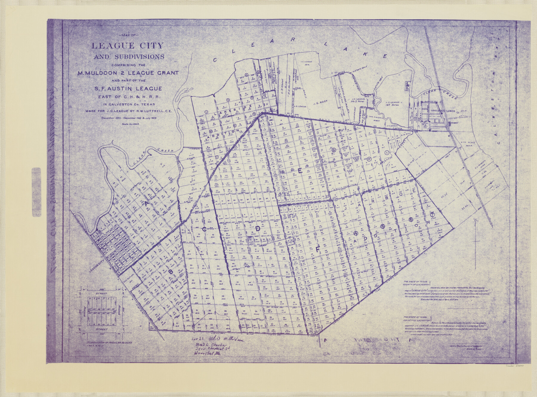
Map of League City and Subdivisions comprising the M. Muldoon 2 League Grant and part of the S.F. Austin League east of G. H. & H. R.R.
-
Map/Doc
87500
-
Collection
General Map Collection
-
Object Dates
1893 (Creation Date)
1907 (Revision Date)
1909 (Revision Date)
-
People and Organizations
R.W. Luttrell (Surveyor/Engineer)
-
Counties
Galveston
-
Subjects
City
-
Height x Width
27.7 x 37.4 inches
70.4 x 95.0 cm
-
Medium
blueprint/diazo
-
Scale
1" = 1000 ft.
-
Features
League City
Clear Lake
Galveston Bay
Clear Creek
Kemah
Jarboe Creek
Robinson's Bayou
Part of: General Map Collection
[Surveys along the Medina River]
![52, [Surveys along the Medina River], General Map Collection](https://historictexasmaps.com/wmedia_w700/maps/52.tif.jpg)
Print $2.00
- Digital $50.00
[Surveys along the Medina River]
1840
Size 8.2 x 14.3 inches
Map/Doc 52
Office sketch of surveys on St. Joseph Island and Mustang Island in Aransas & Nueces Cos.

Print $20.00
- Digital $50.00
Office sketch of surveys on St. Joseph Island and Mustang Island in Aransas & Nueces Cos.
1978
Size 42.8 x 17.7 inches
Map/Doc 2252
McMullen County

Print $40.00
- Digital $50.00
McMullen County
1918
Size 48.3 x 36.1 inches
Map/Doc 66923
Fractional Township No. 10 South Range No. 25 East of the Indian Meridian, Indian Territory

Print $20.00
- Digital $50.00
Fractional Township No. 10 South Range No. 25 East of the Indian Meridian, Indian Territory
1898
Size 19.2 x 24.3 inches
Map/Doc 75244
Presidio County Sketch File 6

Print $20.00
- Digital $50.00
Presidio County Sketch File 6
Size 21.3 x 17.8 inches
Map/Doc 11705
Andrews County Rolled Sketch 32

Print $20.00
- Digital $50.00
Andrews County Rolled Sketch 32
1950
Size 26.2 x 16.4 inches
Map/Doc 77176
Supreme Court of the United States, October Term, 1923, No. 15, Original - The State of Oklahoma, Complainant vs. The State of Texas, Defendant, The United States, Intervener; Report of Medial Line Survey

Print $28.00
- Digital $50.00
Supreme Court of the United States, October Term, 1923, No. 15, Original - The State of Oklahoma, Complainant vs. The State of Texas, Defendant, The United States, Intervener; Report of Medial Line Survey
1924
Size 5.9 x 9.1 inches
Map/Doc 3055
Lipscomb County Working Sketch 4

Print $40.00
- Digital $50.00
Lipscomb County Working Sketch 4
1974
Size 51.7 x 43.8 inches
Map/Doc 70580
Sutton County Rolled Sketch 51

Print $20.00
- Digital $50.00
Sutton County Rolled Sketch 51
1950
Size 29.6 x 16.4 inches
Map/Doc 7891
Uvalde County Sketch File 9

Print $4.00
- Digital $50.00
Uvalde County Sketch File 9
Size 6.8 x 8.8 inches
Map/Doc 38967
Palo Pinto County Working Sketch 17

Print $40.00
- Digital $50.00
Palo Pinto County Working Sketch 17
1974
Size 30.0 x 53.8 inches
Map/Doc 71400
Bell County Working Sketch 14

Print $20.00
- Digital $50.00
Bell County Working Sketch 14
1966
Size 38.7 x 30.8 inches
Map/Doc 67354
You may also like
Map of Polk County

Print $20.00
- Digital $50.00
Map of Polk County
1879
Size 27.1 x 20.8 inches
Map/Doc 3959
Hutchinson County Working Sketch 41

Print $20.00
- Digital $50.00
Hutchinson County Working Sketch 41
1978
Size 26.8 x 22.3 inches
Map/Doc 66401
Map of Matagorda County
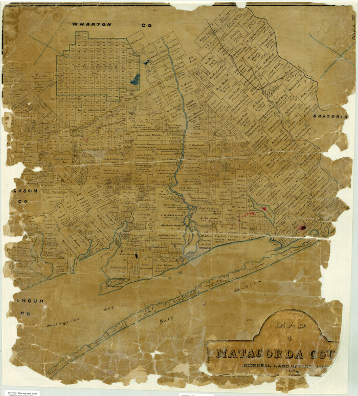
Print $20.00
- Digital $50.00
Map of Matagorda County
1883
Size 29.4 x 26.6 inches
Map/Doc 3840
Map of San Gabriel & Lampassas [sic] Surveys
![58, Map of San Gabriel & Lampassas [sic] Surveys, General Map Collection](https://historictexasmaps.com/wmedia_w700/maps/58.tif.jpg)
Print $20.00
- Digital $50.00
Map of San Gabriel & Lampassas [sic] Surveys
1841
Size 29.0 x 20.0 inches
Map/Doc 58
Sterling County Rolled Sketch 24

Print $20.00
- Digital $50.00
Sterling County Rolled Sketch 24
Size 25.8 x 19.6 inches
Map/Doc 7850
Current Miscellaneous File 48

Print $32.00
- Digital $50.00
Current Miscellaneous File 48
Size 11.2 x 8.7 inches
Map/Doc 73996
Uvalde County Working Sketch 15

Print $20.00
- Digital $50.00
Uvalde County Working Sketch 15
1945
Size 18.5 x 26.9 inches
Map/Doc 72085
Mills County Working Sketch 24

Print $20.00
- Digital $50.00
Mills County Working Sketch 24
1988
Size 40.3 x 36.5 inches
Map/Doc 71054
Washburn situated in Armstrong County, Texas on surveys 62, 63, 98 & 99, Block B4

Print $20.00
- Digital $50.00
Washburn situated in Armstrong County, Texas on surveys 62, 63, 98 & 99, Block B4
Size 44.2 x 31.4 inches
Map/Doc 90261
[Surveys in the Jefferson District]
![69726, [Surveys in the Jefferson District], General Map Collection](https://historictexasmaps.com/wmedia_w700/maps/69726-1.tif.jpg)
Print $20.00
- Digital $50.00
[Surveys in the Jefferson District]
1841
Size 14.6 x 21.2 inches
Map/Doc 69726
Crockett County Sketch File 75

Print $20.00
- Digital $50.00
Crockett County Sketch File 75
Size 26.3 x 28.8 inches
Map/Doc 11234
Brooks County Rolled Sketch 21

Print $40.00
- Digital $50.00
Brooks County Rolled Sketch 21
1943
Size 51.5 x 41.3 inches
Map/Doc 8537