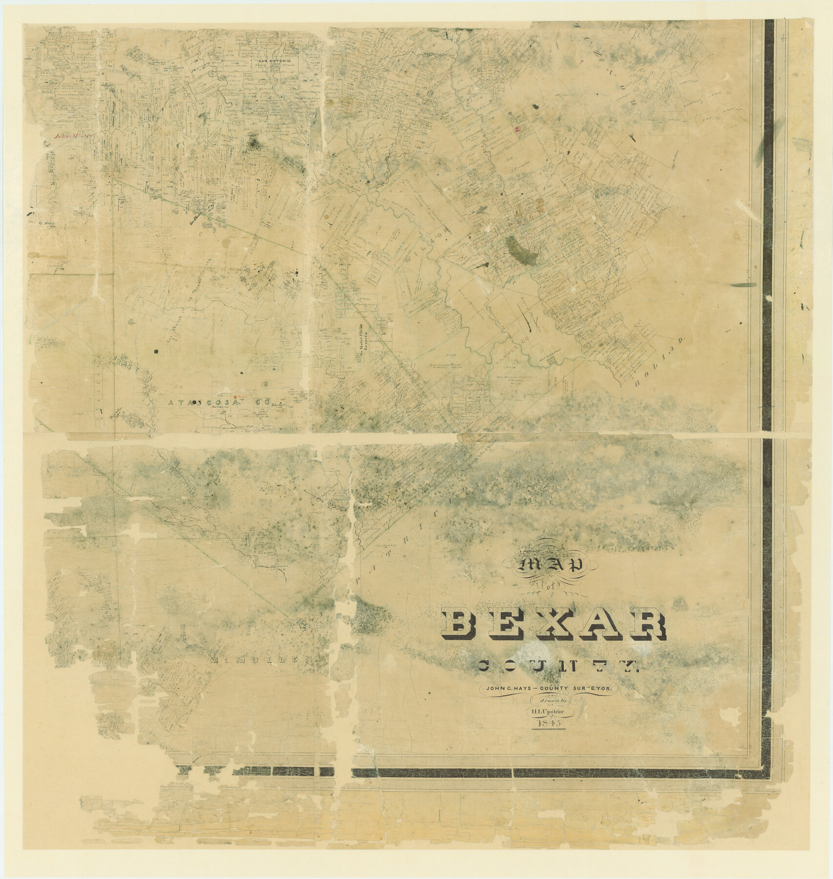
Map of Bexar County
-
Map/Doc
87234
-
Collection
General Map Collection
-
Object Dates
1845 (Creation Date)
-
People and Organizations
John C. Hays (Surveyor/Engineer)
H.L. Upshur (Draftsman)
-
Counties
Bexar Zavala Frio Atascosa Karnes Goliad
-
Subjects
County
-
Height x Width
47.4 x 44.9 inches
120.4 x 114.1 cm
-
Comments
This is the southeast quarter of this large map. For the other pieces see maps 87235, 87236, and 87237.
For a digital composite of the full map see map 82242.
Adopted in 2006 in Memory of Charles Wallace Pratt by loved ones and conservation funded in 2007.
Related maps
Map of Bexar County

Print $40.00
- Digital $50.00
Map of Bexar County
1845
Size 90.6 x 81.0 inches
Map/Doc 82242
Map of Bexar County

Print $20.00
- Digital $50.00
Map of Bexar County
1845
Size 47.5 x 41.7 inches
Map/Doc 87235
Map of Bexar County

Print $40.00
- Digital $50.00
Map of Bexar County
1845
Size 49.0 x 46.5 inches
Map/Doc 87236
Map of Bexar County

Print $40.00
- Digital $50.00
Map of Bexar County
1845
Size 48.8 x 43.0 inches
Map/Doc 87237
Part of: General Map Collection
Flight Mission No. BRA-7M, Frame 73, Jefferson County

Print $20.00
- Digital $50.00
Flight Mission No. BRA-7M, Frame 73, Jefferson County
1953
Size 18.7 x 22.4 inches
Map/Doc 85495
Map of Ramsey State Farm

Print $20.00
- Digital $50.00
Map of Ramsey State Farm
1934
Size 30.3 x 38.0 inches
Map/Doc 94284
New Map of the State of Texas compiled from J. De Cordova's large map

Print $20.00
- Digital $50.00
New Map of the State of Texas compiled from J. De Cordova's large map
1855
Map/Doc 93943
Tom Green County Sketch File 60

Print $20.00
- Digital $50.00
Tom Green County Sketch File 60
1888
Size 28.4 x 25.9 inches
Map/Doc 12444
Kerr County Sketch File 12

Print $4.00
- Digital $50.00
Kerr County Sketch File 12
1901
Size 6.7 x 11.1 inches
Map/Doc 28881
Flight Mission No. CLL-3N, Frame 14, Willacy County

Print $20.00
- Digital $50.00
Flight Mission No. CLL-3N, Frame 14, Willacy County
1954
Size 18.4 x 22.2 inches
Map/Doc 87080
Coryell County Working Sketch 32

Print $20.00
- Digital $50.00
Coryell County Working Sketch 32
2022
Size 25.3 x 36.9 inches
Map/Doc 96966
Map of University Land in McLennan County

Print $20.00
- Digital $50.00
Map of University Land in McLennan County
1905
Size 35.1 x 32.9 inches
Map/Doc 2432
Flight Mission No. CGI-4N, Frame 190, Cameron County

Print $20.00
- Digital $50.00
Flight Mission No. CGI-4N, Frame 190, Cameron County
1955
Size 18.5 x 22.2 inches
Map/Doc 84693
Jefferson County NRC Article 33.136 Sketch 9

Print $22.00
- Digital $50.00
Jefferson County NRC Article 33.136 Sketch 9
2011
Size 24.0 x 36.0 inches
Map/Doc 94517
Blanco County Working Sketch 37

Print $20.00
- Digital $50.00
Blanco County Working Sketch 37
1980
Size 24.9 x 19.0 inches
Map/Doc 67397
Galveston County Rolled Sketch 19

Print $20.00
- Digital $50.00
Galveston County Rolled Sketch 19
Size 21.4 x 28.1 inches
Map/Doc 5957
You may also like
Jeff Davis County Working Sketch Graphic Index - central part

Print $40.00
- Digital $50.00
Jeff Davis County Working Sketch Graphic Index - central part
1982
Size 55.7 x 42.6 inches
Map/Doc 76593
Starr County Working Sketch 22

Print $20.00
- Digital $50.00
Starr County Working Sketch 22
1983
Size 25.8 x 33.1 inches
Map/Doc 63938
Upton County Rolled Sketch 42

Print $40.00
- Digital $50.00
Upton County Rolled Sketch 42
Size 26.5 x 55.9 inches
Map/Doc 10056
Wheeler County Boundary File 1

Print $24.00
- Digital $50.00
Wheeler County Boundary File 1
Size 14.4 x 8.7 inches
Map/Doc 59856
Flight Mission No. DQN-7K, Frame 10, Calhoun County

Print $20.00
- Digital $50.00
Flight Mission No. DQN-7K, Frame 10, Calhoun County
1953
Size 18.1 x 22.1 inches
Map/Doc 84461
Map of the Columbia and Wharton Division of the Galveston & Eagle Pass Airline Railway

Print $20.00
- Digital $50.00
Map of the Columbia and Wharton Division of the Galveston & Eagle Pass Airline Railway
1881
Size 30.3 x 17.3 inches
Map/Doc 64483
Kinney County Sketch File 31

Print $40.00
- Digital $50.00
Kinney County Sketch File 31
1934
Size 15.3 x 13.6 inches
Map/Doc 29176
Garza County Sketch File 19

Print $20.00
- Digital $50.00
Garza County Sketch File 19
1905
Size 21.8 x 23.0 inches
Map/Doc 11546
Maverick County Sketch File 17

Print $20.00
- Digital $50.00
Maverick County Sketch File 17
Size 15.4 x 18.2 inches
Map/Doc 12052
Flight Mission No. CGI-1N, Frame 168, Cameron County

Print $20.00
- Digital $50.00
Flight Mission No. CGI-1N, Frame 168, Cameron County
1955
Size 18.5 x 22.2 inches
Map/Doc 84503
United States - Gulf Coast - Galveston to Rio Grande

Print $20.00
- Digital $50.00
United States - Gulf Coast - Galveston to Rio Grande
1940
Size 27.0 x 18.2 inches
Map/Doc 72755
Fractional Township No. 6 South Range No. 7 West of the Indian Meridian, Indian Territory

Print $20.00
- Digital $50.00
Fractional Township No. 6 South Range No. 7 West of the Indian Meridian, Indian Territory
1898
Size 19.4 x 24.3 inches
Map/Doc 75157