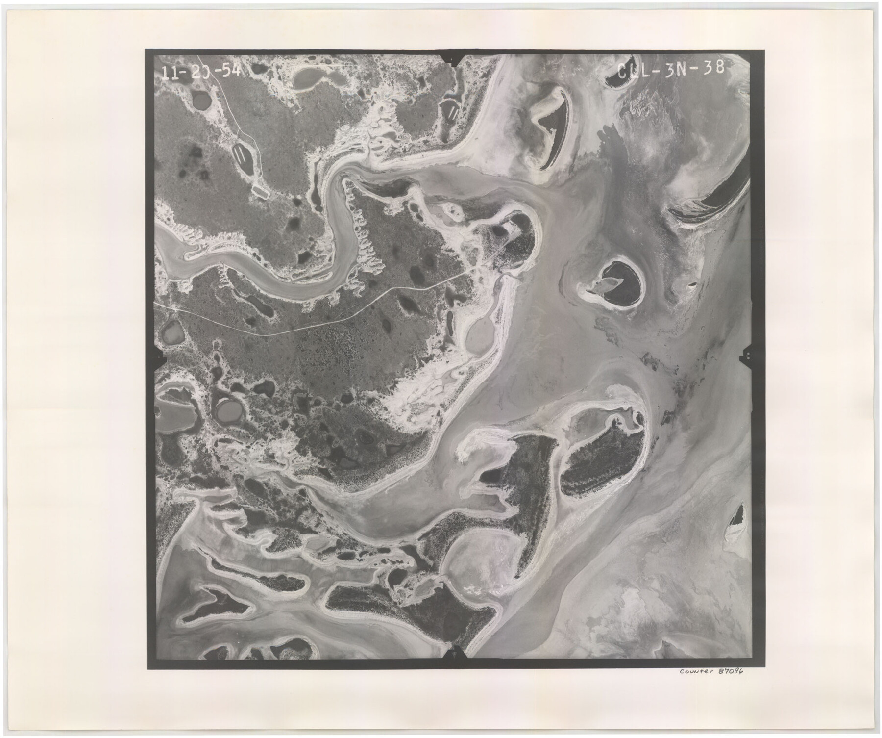
Flight Mission No. CLL-3N, Frame 38, Willacy County
CLL-3N-38
-
Map/Doc
87096
-
Collection
General Map Collection
-
Object Dates
1954/12/29 (Creation Date)
-
People and Organizations
U. S. Department of Agriculture (Publisher)
-
Counties
Willacy
-
Subjects
Aerial Photograph
-
Height x Width
18.6 x 22.2 inches
47.2 x 56.4 cm
-
Comments
Flown by Puckett Aerial Surveys, Inc. of Jackson, Mississippi.
Part of: General Map Collection
Mitchell County Sketch File 10

Print $4.00
- Digital $50.00
Mitchell County Sketch File 10
1909
Size 11.3 x 8.8 inches
Map/Doc 31698
Lamar County Boundary File 56a

Print $34.00
- Digital $50.00
Lamar County Boundary File 56a
Size 8.7 x 14.3 inches
Map/Doc 56020
Caldwell County

Print $20.00
- Digital $50.00
Caldwell County
1935
Size 37.8 x 42.0 inches
Map/Doc 73095
Webb County Working Sketch 67

Print $40.00
- Digital $50.00
Webb County Working Sketch 67
1966
Size 60.9 x 43.7 inches
Map/Doc 72434
Flight Mission No. BRA-9M, Frame 63, Jefferson County

Print $20.00
- Digital $50.00
Flight Mission No. BRA-9M, Frame 63, Jefferson County
1953
Size 18.6 x 22.4 inches
Map/Doc 85646
Webb County Rolled Sketch 74

Print $20.00
- Digital $50.00
Webb County Rolled Sketch 74
1982
Size 40.7 x 31.9 inches
Map/Doc 10131
Brazoria County Working Sketch 15

Print $20.00
- Digital $50.00
Brazoria County Working Sketch 15
1940
Size 18.2 x 38.6 inches
Map/Doc 67500
Hardeman County Rolled Sketch 22

Print $20.00
- Digital $50.00
Hardeman County Rolled Sketch 22
Size 25.8 x 18.6 inches
Map/Doc 6073
Upshur County Working Sketch 15b

Print $20.00
- Digital $50.00
Upshur County Working Sketch 15b
1996
Size 36.7 x 29.4 inches
Map/Doc 69572
Real County Working Sketch 56

Print $20.00
- Digital $50.00
Real County Working Sketch 56
1960
Size 31.1 x 23.9 inches
Map/Doc 71948
Jefferson County Rolled Sketch 31

Print $425.00
- Digital $50.00
Jefferson County Rolled Sketch 31
1955
Size 10.1 x 15.3 inches
Map/Doc 46323
McMullen County Working Sketch 42

Print $20.00
- Digital $50.00
McMullen County Working Sketch 42
1980
Size 35.6 x 32.6 inches
Map/Doc 70743
You may also like
Limestone County Boundary File 1

Print $9.00
- Digital $50.00
Limestone County Boundary File 1
Size 8.8 x 14.5 inches
Map/Doc 56296
Franklin County Sketch File 9

Print $20.00
- Digital $50.00
Franklin County Sketch File 9
Size 13.6 x 23.1 inches
Map/Doc 11515
Val Verde Co.

Print $20.00
- Digital $50.00
Val Verde Co.
1908
Size 41.2 x 37.3 inches
Map/Doc 78447
The Republic County of Lamar. December 26, 1842

Print $20.00
The Republic County of Lamar. December 26, 1842
2020
Size 16.4 x 21.7 inches
Map/Doc 96205
Webb County Sketch File 10-1

Print $20.00
- Digital $50.00
Webb County Sketch File 10-1
1850
Size 14.8 x 15.5 inches
Map/Doc 12625
Flight Mission No. DQO-3K, Frame 31, Galveston County

Print $20.00
- Digital $50.00
Flight Mission No. DQO-3K, Frame 31, Galveston County
1952
Size 18.9 x 22.5 inches
Map/Doc 85072
Fort Bend County State Real Property Sketch 14

Print $40.00
- Digital $50.00
Fort Bend County State Real Property Sketch 14
1985
Size 36.7 x 35.6 inches
Map/Doc 61688
The Republic County of San Patricio. 1840

Print $20.00
The Republic County of San Patricio. 1840
2020
Size 22.2 x 21.7 inches
Map/Doc 96276
Uvalde County Sketch File 26-2

Print $6.00
- Digital $50.00
Uvalde County Sketch File 26-2
1942
Size 11.4 x 9.0 inches
Map/Doc 39020
Map of Taylor County Travis- Young- Bexar- Land District

Print $20.00
- Digital $50.00
Map of Taylor County Travis- Young- Bexar- Land District
1859
Size 25.1 x 20.4 inches
Map/Doc 4071
[Galveston, Harrisburg & San Antonio Railroad from Cuero to Stockdale]
![64200, [Galveston, Harrisburg & San Antonio Railroad from Cuero to Stockdale], General Map Collection](https://historictexasmaps.com/wmedia_w700/maps/64200.tif.jpg)
Print $20.00
- Digital $50.00
[Galveston, Harrisburg & San Antonio Railroad from Cuero to Stockdale]
1907
Size 14.0 x 34.1 inches
Map/Doc 64200
Map of Chicago, Rock Island & Texas Railroad

Print $40.00
- Digital $50.00
Map of Chicago, Rock Island & Texas Railroad
1892
Size 23.9 x 122.0 inches
Map/Doc 64442