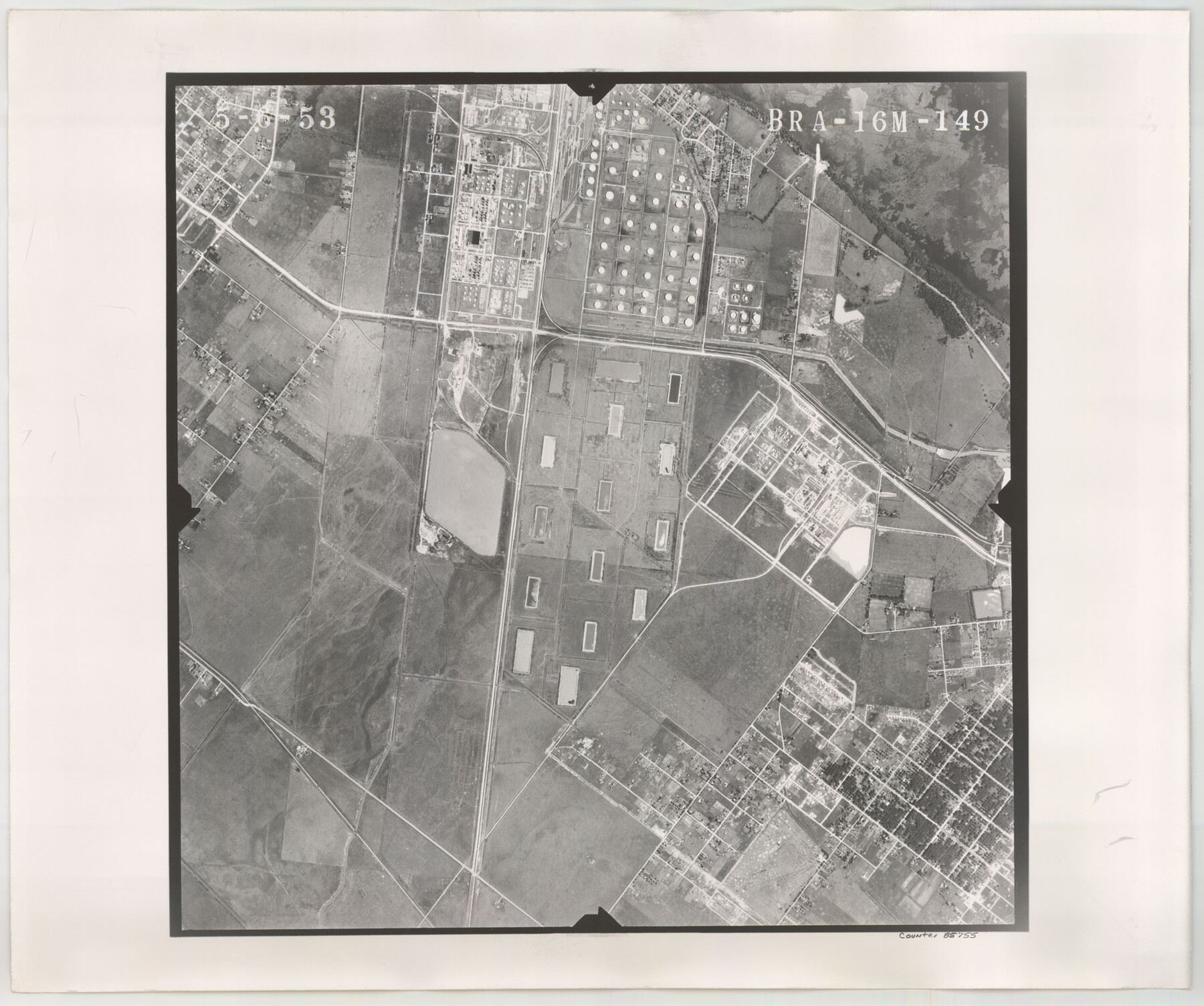
Flight Mission No. BRA-16M, Frame 149, Jefferson County
BRA-16M-149
-
Map/Doc
85755
-
Collection
General Map Collection
-
Object Dates
1953/5/6 (Creation Date)
-
People and Organizations
U. S. Department of Agriculture (Publisher)
-
Counties
Jefferson
-
Subjects
Aerial Photograph
-
Height x Width
18.6 x 22.3 inches
47.2 x 56.6 cm
-
Comments
Flown by Jack Ammann Photogrammetric Engineers of San Antonio, Texas.
Part of: General Map Collection
Sutton County Working Sketch 60

Print $20.00
- Digital $50.00
Sutton County Working Sketch 60
1959
Size 29.1 x 34.6 inches
Map/Doc 62403
Val Verde County Working Sketch 117

Print $20.00
- Digital $50.00
Val Verde County Working Sketch 117
1993
Size 33.8 x 37.0 inches
Map/Doc 82842
Runnels County Working Sketch 22
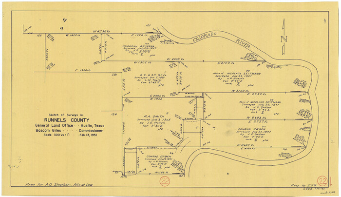
Print $20.00
- Digital $50.00
Runnels County Working Sketch 22
1951
Size 16.2 x 28.1 inches
Map/Doc 63618
Ellis County Sketch File 20

Print $19.00
- Digital $50.00
Ellis County Sketch File 20
1869
Size 12.8 x 8.2 inches
Map/Doc 21869
Schleicher County Rolled Sketch 16

Print $20.00
- Digital $50.00
Schleicher County Rolled Sketch 16
Size 27.4 x 29.0 inches
Map/Doc 7758
Gregg County Rolled Sketch MHH

Print $203.00
- Digital $50.00
Gregg County Rolled Sketch MHH
1935
Size 10.5 x 15.5 inches
Map/Doc 45668

Flight Mission No. CGI-4N, Frame 178, Cameron County

Print $20.00
- Digital $50.00
Flight Mission No. CGI-4N, Frame 178, Cameron County
1955
Size 18.6 x 22.3 inches
Map/Doc 84681
Flight Mission No. BRA-3M, Frame 125, Jefferson County

Print $20.00
- Digital $50.00
Flight Mission No. BRA-3M, Frame 125, Jefferson County
1953
Size 18.6 x 21.5 inches
Map/Doc 85399
Outer Continental Shelf Leasing Maps (Texas Offshore Operations)

Print $20.00
- Digital $50.00
Outer Continental Shelf Leasing Maps (Texas Offshore Operations)
Size 14.7 x 17.4 inches
Map/Doc 75845
[Sketch for Mineral Application 33721 - 33725 Incl. - Padre and Mustang Island]
![2871, [Sketch for Mineral Application 33721 - 33725 Incl. - Padre and Mustang Island], General Map Collection](https://historictexasmaps.com/wmedia_w700/maps/2871.tif.jpg)
Print $20.00
- Digital $50.00
[Sketch for Mineral Application 33721 - 33725 Incl. - Padre and Mustang Island]
1942
Size 27.0 x 22.4 inches
Map/Doc 2871
That part of the boundary between the Republic of Texas and the United States, North of Sabine River from the 36th to the 72nd Mile Mound on the Meridian Line (Sheet No. 2)

Print $20.00
- Digital $50.00
That part of the boundary between the Republic of Texas and the United States, North of Sabine River from the 36th to the 72nd Mile Mound on the Meridian Line (Sheet No. 2)
1842
Size 33.7 x 26.0 inches
Map/Doc 3132
You may also like
Jasper County Working Sketch 25

Print $20.00
- Digital $50.00
Jasper County Working Sketch 25
1951
Size 21.6 x 32.3 inches
Map/Doc 66487
Garza County Boundary File 2

Print $6.00
- Digital $50.00
Garza County Boundary File 2
Size 14.9 x 9.2 inches
Map/Doc 53673
Fannin County Boundary File 5

Print $44.00
- Digital $50.00
Fannin County Boundary File 5
Size 22.3 x 7.7 inches
Map/Doc 53309
Moore County Working Sketch 4

Print $20.00
- Digital $50.00
Moore County Working Sketch 4
1911
Size 20.1 x 15.6 inches
Map/Doc 71186
Colorado County Working Sketch 9

Print $20.00
- Digital $50.00
Colorado County Working Sketch 9
1939
Size 12.0 x 15.7 inches
Map/Doc 68109
San Jacinto County Working Sketch 30

Print $20.00
- Digital $50.00
San Jacinto County Working Sketch 30
Size 18.2 x 24.4 inches
Map/Doc 63743
Presidio County Sketch File 61

Print $3.00
- Digital $50.00
Presidio County Sketch File 61
1930
Size 9.3 x 15.4 inches
Map/Doc 89987
Liberty County Working Sketch 5

Print $20.00
- Digital $50.00
Liberty County Working Sketch 5
1901
Size 41.9 x 36.5 inches
Map/Doc 70464
Texas Intracoastal Waterway - Laguna Madre - Dagger Hill to Potrero Grande

Print $20.00
- Digital $50.00
Texas Intracoastal Waterway - Laguna Madre - Dagger Hill to Potrero Grande
1960
Size 38.3 x 27.0 inches
Map/Doc 73511
Travis County State Real Property Sketch 13

Print $26.00
- Digital $50.00
Travis County State Real Property Sketch 13
2006
Size 35.3 x 24.1 inches
Map/Doc 88620
Lamb County Boundary File 4

Print $16.00
- Digital $50.00
Lamb County Boundary File 4
Size 11.3 x 8.7 inches
Map/Doc 56084
Flight Mission No. CRC-3R, Frame 46, Chambers County

Print $20.00
- Digital $50.00
Flight Mission No. CRC-3R, Frame 46, Chambers County
1956
Size 18.6 x 22.5 inches
Map/Doc 84819