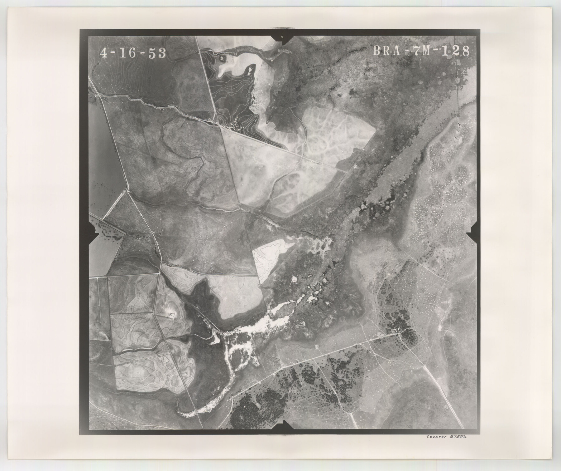
Flight Mission No. BRA-7M, Frame 128, Jefferson County
BRA-7M-128
-
Map/Doc
85522
-
Collection
General Map Collection
-
Object Dates
1953/4/16 (Creation Date)
-
People and Organizations
U. S. Department of Agriculture (Publisher)
-
Counties
Jefferson
-
Subjects
Aerial Photograph
-
Height x Width
18.8 x 22.5 inches
47.8 x 57.2 cm
-
Comments
Flown by Jack Ammann Photogrammetric Engineers of San Antonio, Texas.
Part of: General Map Collection
Duval County Sketch File 40b

Print $20.00
- Digital $50.00
Duval County Sketch File 40b
Size 28.0 x 31.4 inches
Map/Doc 11396
Val Verde County Sketch File A3

Print $20.00
- Digital $50.00
Val Verde County Sketch File A3
1917
Size 25.6 x 42.3 inches
Map/Doc 10418
Pecos County Sketch File 84

Print $4.00
- Digital $50.00
Pecos County Sketch File 84
1944
Size 11.2 x 8.8 inches
Map/Doc 33953
Map of Stephens County

Print $20.00
- Digital $50.00
Map of Stephens County
1897
Size 43.0 x 37.3 inches
Map/Doc 78395
Angelina County Sketch File 11a

Print $4.00
- Digital $50.00
Angelina County Sketch File 11a
1860
Size 14.4 x 8.3 inches
Map/Doc 12942
Pecos County Rolled Sketch 69

Print $20.00
- Digital $50.00
Pecos County Rolled Sketch 69
Size 37.9 x 33.8 inches
Map/Doc 9701

Culberson County Rolled Sketch 41

Print $88.00
- Digital $50.00
Culberson County Rolled Sketch 41
1944
Size 57.5 x 46.0 inches
Map/Doc 8752
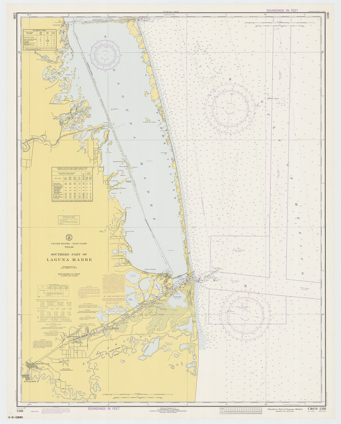
Southern Part of Laguna Madre
Print $20.00
- Digital $50.00
Southern Part of Laguna Madre
1972
Size 44.3 x 35.6 inches
Map/Doc 73542
Robertson County Working Sketch 12

Print $20.00
- Digital $50.00
Robertson County Working Sketch 12
1984
Size 20.6 x 22.4 inches
Map/Doc 63585
Val Verde County Working Sketch 89

Print $20.00
- Digital $50.00
Val Verde County Working Sketch 89
1974
Size 24.5 x 29.0 inches
Map/Doc 72224
McCulloch County Sketch File 12

Print $6.00
- Digital $50.00
McCulloch County Sketch File 12
1989
Size 14.2 x 8.6 inches
Map/Doc 31198
You may also like

General Chart of the Coast No. XVI - Gulf Coast from Galveston to the Rio Grande

Print $20.00
- Digital $50.00
General Chart of the Coast No. XVI - Gulf Coast from Galveston to the Rio Grande
1883
Size 26.7 x 18.2 inches
Map/Doc 72738
Walker County Working Sketch 6

Print $20.00
- Digital $50.00
Walker County Working Sketch 6
1935
Size 30.8 x 40.6 inches
Map/Doc 72286
Matagorda County Rolled Sketch H & W

Matagorda County Rolled Sketch H & W
1936
Size 27.1 x 41.2 inches
Map/Doc 61776
Jefferson County NRC Article 33.136 Sketch 9

Print $22.00
- Digital $50.00
Jefferson County NRC Article 33.136 Sketch 9
2011
Size 24.0 x 36.0 inches
Map/Doc 94517
Marion County Sketch File 13

Print $24.00
- Digital $50.00
Marion County Sketch File 13
1912
Size 11.3 x 8.7 inches
Map/Doc 30583
Andrews County Working Sketch 2

Print $20.00
- Digital $50.00
Andrews County Working Sketch 2
1949
Size 23.2 x 23.7 inches
Map/Doc 67048
Angelina County Working Sketch 45

Print $20.00
- Digital $50.00
Angelina County Working Sketch 45
1976
Size 25.8 x 29.7 inches
Map/Doc 67128
Kinney County Sketch File 35

Print $6.00
- Digital $50.00
Kinney County Sketch File 35
1944
Size 14.2 x 8.7 inches
Map/Doc 29185

Uvalde County Working Sketch 30

Print $20.00
- Digital $50.00
Uvalde County Working Sketch 30
1962
Size 27.9 x 40.9 inches
Map/Doc 72100
Pecos County Working Sketch 74

Print $40.00
- Digital $50.00
Pecos County Working Sketch 74
1957
Size 101.0 x 38.7 inches
Map/Doc 71546