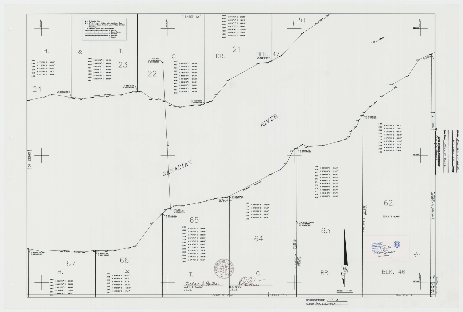
Hutchinson County Rolled Sketch 44-13
Canadian River Survey, Hutchinson County, Texas [Sheet 13 of 19]
- 
                          Map/Doc
77549
 - 
                            Collection
General Map Collection
 - 
                            Object Dates
2002/8/15 (Creation Date)
2002/9/18 (File Date)
 - 
                            People and Organizations
Nedra J. Foster (Surveyor/Engineer)
D.D. Shine (Surveyor/Engineer)
 - 
                            Counties
Hutchinson
 - 
                            Subjects
Surveying Rolled Sketch
 - 
                            Height x Width
24.0 x 36.0 inches
61.0 x 91.4 cm
 - 
                            Medium
mylar, print
 - 
                            Scale
1" = 500 feet
 
Part of: General Map Collection
            Presidio County Working Sketch 5


                                            Print $20.00                    
                                             -                         Digital $50.00                                    
                Presidio County Working Sketch 5
1917
Size 14.0 x 17.5 inches
                                Map/Doc 71679
            
            Travis County Appraisal District Plat Map 3_0721


                                            Print $20.00                    
                                             -                         Digital $50.00                                    
                Travis County Appraisal District Plat Map 3_0721
Size 21.5 x 26.3 inches
                                Map/Doc 94227
            
            Tom Green County Sketch File 58


                                            Print $6.00                    
                                             -                         Digital $50.00                                    
                Tom Green County Sketch File 58
Size 15.9 x 9.4 inches
                                Map/Doc 38225
            
            Flight Mission No. BRA-9M, Frame 64, Jefferson County


                                            Print $20.00                    
                                             -                         Digital $50.00                                    
                Flight Mission No. BRA-9M, Frame 64, Jefferson County
1953
Size 18.6 x 22.4 inches
                                Map/Doc 85647
            
            Bowie County Boundary File 72 (23)


                                            Print $10.00                    
                                             -                         Digital $50.00                                    
                Bowie County Boundary File 72 (23)
Size 13.0 x 8.0 inches
                                Map/Doc 50694
            
            Maverick County Sketch File 27


                                            Print $6.00                    
                                             -                         Digital $50.00                                    
                Maverick County Sketch File 27
1873
Size 9.9 x 8.0 inches
                                Map/Doc 31160
            
            Map of Collin County


                                            Print $20.00                    
                                             -                         Digital $50.00                                    
                Map of Collin County
1862
Size 24.4 x 20.5 inches
                                Map/Doc 1084
            
            Burnet County Sketch File 20


                                            Print $4.00                    
                                             -                         Digital $50.00                                    
                Burnet County Sketch File 20
1862
Size 10.1 x 8.0 inches
                                Map/Doc 16712
            
            St. Louis, Brownsville & Mexico Railway Location map from Mile 40 to Mile 60


                                            Print $40.00                    
                                             -                         Digital $50.00                                    
                St. Louis, Brownsville & Mexico Railway Location map from Mile 40 to Mile 60
1905
Size 19.3 x 61.9 inches
                                Map/Doc 64080
            
            McCulloch County Rolled Sketch 8


                                            Print $40.00                    
                                             -                         Digital $50.00                                    
                McCulloch County Rolled Sketch 8
1982
Size 51.3 x 31.4 inches
                                Map/Doc 10292
            
            Outer Continental Shelf Leasing Maps (Louisiana Offshore Operations)


                                            Print $20.00                    
                                             -                         Digital $50.00                                    
                Outer Continental Shelf Leasing Maps (Louisiana Offshore Operations)
1954
Size 22.2 x 12.0 inches
                                Map/Doc 76096
            
            Right of Way and Track Map Houston & Texas Central R.R. operated by the T. and N. O. R.R. Co., Fort Worth Branch


                                            Print $40.00                    
                                             -                         Digital $50.00                                    
                Right of Way and Track Map Houston & Texas Central R.R. operated by the T. and N. O. R.R. Co., Fort Worth Branch
1918
Size 31.4 x 58.5 inches
                                Map/Doc 64544
            You may also like
            Brewster County Rolled Sketch 22F


                                            Print $20.00                    
                                             -                         Digital $50.00                                    
                Brewster County Rolled Sketch 22F
1909
Size 19.0 x 25.4 inches
                                Map/Doc 5206
            
            Somervell County Working Sketch 6


                                            Print $20.00                    
                                             -                         Digital $50.00                                    
                Somervell County Working Sketch 6
1992
Size 23.2 x 21.5 inches
                                Map/Doc 63910
            
            Brewster County Working Sketch 40


                                            Print $20.00                    
                                             -                         Digital $50.00                                    
                Brewster County Working Sketch 40
1944
Size 16.1 x 26.1 inches
                                Map/Doc 67574
            
            Map of Port Bolivar


                                            Print $20.00                    
                                             -                         Digital $50.00                                    
                Map of Port Bolivar
1893
Size 24.9 x 18.5 inches
                                Map/Doc 2191
            
            Comanche County Rolled Sketch 2


                                            Print $40.00                    
                                             -                         Digital $50.00                                    
                Comanche County Rolled Sketch 2
1989
Size 36.9 x 48.6 inches
                                Map/Doc 10299
            
            General Highway Map, Polk County, Texas


                                            Print $20.00                    
                                    
                General Highway Map, Polk County, Texas
1961
Size 18.2 x 24.4 inches
                                Map/Doc 79629
            
            Ward County Working Sketch 2


                                            Print $20.00                    
                                             -                         Digital $50.00                                    
                Ward County Working Sketch 2
1937
Size 22.9 x 28.7 inches
                                Map/Doc 72308
            
            Presidio County Working Sketch 9a


                                            Print $20.00                    
                                             -                         Digital $50.00                                    
                Presidio County Working Sketch 9a
1933
Size 17.3 x 12.2 inches
                                Map/Doc 71684
            
            Tom Green County Rolled Sketch 22


                                            Print $20.00                    
                                             -                         Digital $50.00                                    
                Tom Green County Rolled Sketch 22
1966
Size 38.0 x 43.6 inches
                                Map/Doc 10006
            
            Goliad County Working Sketch 2


                                            Print $20.00                    
                                             -                         Digital $50.00                                    
                Goliad County Working Sketch 2
1916
Size 15.5 x 21.6 inches
                                Map/Doc 63192
            
            Section 54 Block Y


                                            Print $20.00                    
                                             -                         Digital $50.00                                    
                Section 54 Block Y
Size 23.9 x 19.4 inches
                                Map/Doc 92462
            
            Hardin County Sketch File X


                                            Print $9.00                    
                                             -                         Digital $50.00                                    
                Hardin County Sketch File X
Size 8.2 x 8.3 inches
                                Map/Doc 25075