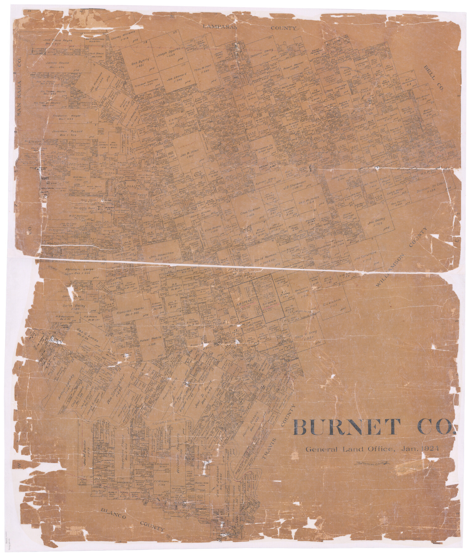
Burnet Co.
-
Map/Doc
73094
-
Collection
General Map Collection
-
Object Dates
1924 (Creation Date)
-
People and Organizations
Texas General Land Office (Publisher)
H.F. McDonald (Draftsman)
-
Counties
Burnet
-
Subjects
County
-
Height x Width
45.1 x 38.7 inches
114.6 x 98.3 cm
-
Comments
Hand lettered.
-
Features
South Fork of San Gabriel River
Burnet
Love Creek
Deep Creek
Little Creek
Double Horn Creek
Marble Falls
Flat Rock Creek
Colorado River
Richardson Creek
Hamilton Creek
Sudduth
Fairland
Sono Stone Mountain
Winston
Sand Fork [of Lampasas River]
Bertram
Russell Fork [of San Gabriel River]
San Gabriel River
North Fork of San Gabriel River
Morgans Creek
Lake Victor
Lake Victor
Mesquite Creek
Mill Creek
T[ ]r Creek
Rocky Creek
Lampasas River
H&TC
Sulphur Fork [of Lampasas River]
Part of: General Map Collection
Archer County Sketch File 8

Print $40.00
- Digital $50.00
Archer County Sketch File 8
Size 40.9 x 31.5 inches
Map/Doc 10336

Maverick County Sketch File 10

Print $22.00
- Digital $50.00
Maverick County Sketch File 10
Size 8.6 x 7.0 inches
Map/Doc 31072
Childress County

Print $20.00
- Digital $50.00
Childress County
1884
Size 20.6 x 17.4 inches
Map/Doc 3395
[Right of Way Map, Belton Branch of the M.K.&T. RR.]
![64715, [Right of Way Map, Belton Branch of the M.K.&T. RR.], General Map Collection](https://historictexasmaps.com/wmedia_w700/maps/64715-1.tif.jpg)
Print $2.00
- Digital $50.00
[Right of Way Map, Belton Branch of the M.K.&T. RR.]
1896
Size 11.1 x 8.3 inches
Map/Doc 64715
Travis County Sketch File 37

Print $4.00
- Digital $50.00
Travis County Sketch File 37
Size 8.2 x 10.1 inches
Map/Doc 38357
Cottle County Rolled Sketch 12

Print $20.00
- Digital $50.00
Cottle County Rolled Sketch 12
1959
Size 41.1 x 30.9 inches
Map/Doc 5570
Callahan County Sketch File 10

Print $40.00
- Digital $50.00
Callahan County Sketch File 10
Size 21.7 x 24.7 inches
Map/Doc 11039
Terrell County Working Sketch 59

Print $20.00
- Digital $50.00
Terrell County Working Sketch 59
1961
Size 20.3 x 21.8 inches
Map/Doc 69580
Pottsboro Quadrangle

Print $20.00
- Digital $50.00
Pottsboro Quadrangle
1999
Size 35.4 x 23.4 inches
Map/Doc 97363
Montgomery County Sketch File 5

Print $5.00
- Digital $50.00
Montgomery County Sketch File 5
Size 9.8 x 16.4 inches
Map/Doc 31779
Reeves County Working Sketch 9

Print $20.00
- Digital $50.00
Reeves County Working Sketch 9
1948
Size 19.0 x 24.0 inches
Map/Doc 63452
You may also like
Cameron County Rolled Sketch 15

Print $40.00
- Digital $50.00
Cameron County Rolled Sketch 15
1958
Size 53.0 x 32.0 inches
Map/Doc 8568
J. O. Jones Land, Gaines County, Texas - Cedar Lake Meridian

Print $20.00
- Digital $50.00
J. O. Jones Land, Gaines County, Texas - Cedar Lake Meridian
Size 8.5 x 32.1 inches
Map/Doc 90792
[Township 5-S, Blocks 37 & 38]
![92801, [Township 5-S, Blocks 37 & 38], Twichell Survey Records](https://historictexasmaps.com/wmedia_w700/maps/92801-1.tif.jpg)
Print $20.00
- Digital $50.00
[Township 5-S, Blocks 37 & 38]
Size 23.3 x 17.5 inches
Map/Doc 92801
General Highway Map, Henderson County, Texas

Print $20.00
General Highway Map, Henderson County, Texas
1961
Size 24.9 x 18.0 inches
Map/Doc 79517
The Republic County of Harrison. Created, January 28, 1839

Print $20.00
The Republic County of Harrison. Created, January 28, 1839
2020
Size 18.6 x 21.7 inches
Map/Doc 96169
Flight Mission No. DCL-6C, Frame 68, Kenedy County

Print $20.00
- Digital $50.00
Flight Mission No. DCL-6C, Frame 68, Kenedy County
1943
Size 18.6 x 22.4 inches
Map/Doc 85910
Tom Green County Sketch File 58

Print $6.00
- Digital $50.00
Tom Green County Sketch File 58
Size 15.9 x 9.4 inches
Map/Doc 38225
Cottle County Sketch File 14

Print $50.00
- Digital $50.00
Cottle County Sketch File 14
1918
Size 11.3 x 8.8 inches
Map/Doc 19491
Flight Mission No. CUG-1P, Frame 72, Kleberg County

Print $20.00
- Digital $50.00
Flight Mission No. CUG-1P, Frame 72, Kleberg County
1956
Size 18.6 x 22.1 inches
Map/Doc 86137
International Boundary Line in the Rio Grande delineated in accordance with the Treaty of 1970 - (1982/1983 Aerial Photographs)

International Boundary Line in the Rio Grande delineated in accordance with the Treaty of 1970 - (1982/1983 Aerial Photographs)
1982
Map/Doc 74827

Hill County Sketch File 23

Print $8.00
- Digital $50.00
Hill County Sketch File 23
1862
Size 7.9 x 8.3 inches
Map/Doc 26512