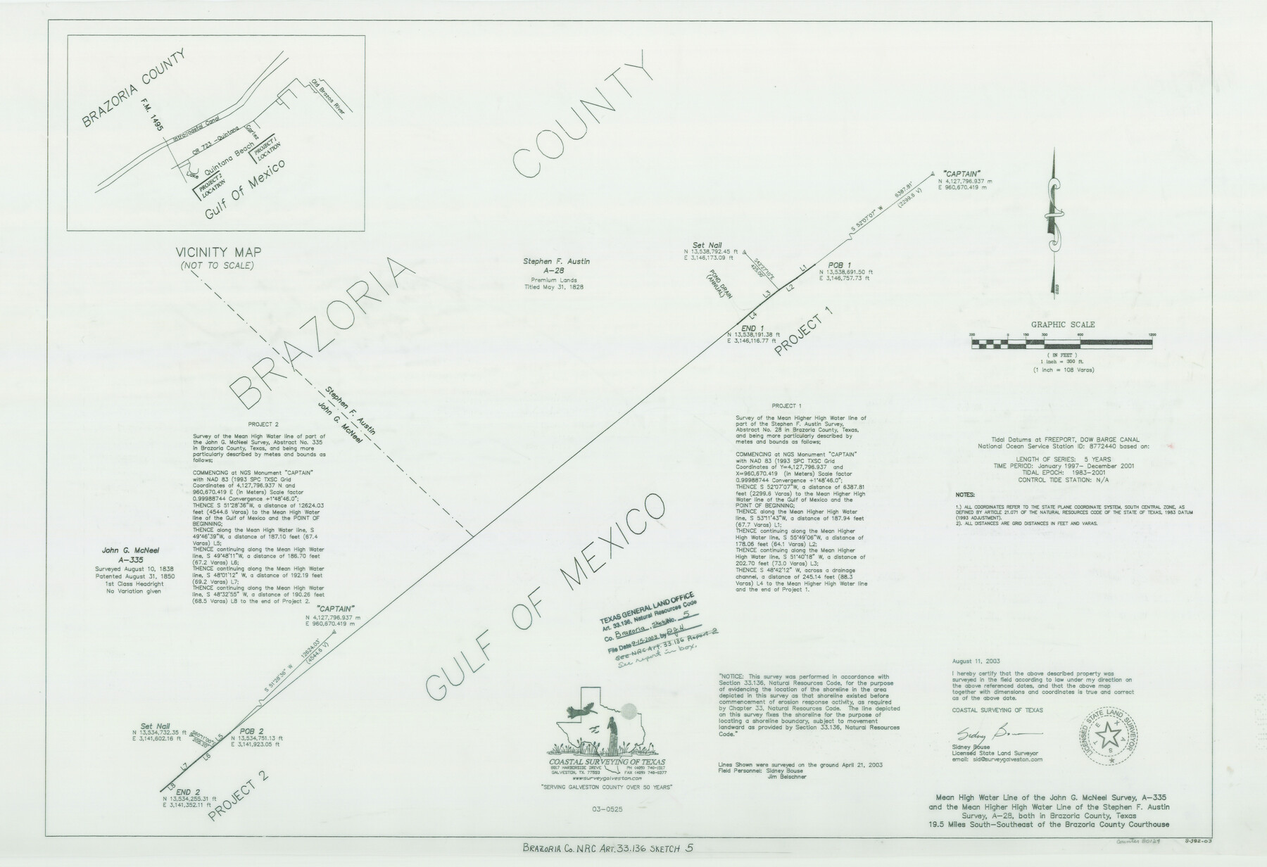
Brazoria County NRC Article 33.136 Sketch 5
Mean High Water Line of The John G. McNeel Survey, Abstract 335 and The Mean Higher High Water Line of The Stephen F. Austin Survey, Abstract 28, Quintana Beach
-
Map/Doc
80124
-
Collection
General Map Collection
-
Object Dates
2003/8/11 (Creation Date)
2003/9/15 (File Date)
-
People and Organizations
Coastal Surveying of Texas (Publisher)
Coastal Surveying of Texas (Printer)
Sidney Bouse (Surveyor/Engineer)
-
Counties
Brazoria
-
Subjects
Surveying CBS
-
Height x Width
24.2 x 35.4 inches
61.5 x 89.9 cm
-
Medium
multi-page, multi-format
-
Comments
Survey located 18 1/2 miles South 22 degrees East of Angleton, Texas.
One or more items in this file were formerly filed in another file. They have been reunited in this file with their original grouping. The old name on these sheets has been crossed
Part of: General Map Collection
La Salle County Sketch File 46

Print $20.00
- Digital $50.00
La Salle County Sketch File 46
Size 14.1 x 8.6 inches
Map/Doc 29603
Presidio County Sketch File 61

Print $3.00
- Digital $50.00
Presidio County Sketch File 61
1930
Size 9.3 x 15.4 inches
Map/Doc 89987
Burnet County Rolled Sketch 6

Print $40.00
- Digital $50.00
Burnet County Rolled Sketch 6
1971
Size 36.4 x 49.5 inches
Map/Doc 8543
Flight Mission No. DQN-5K, Frame 73, Calhoun County

Print $20.00
- Digital $50.00
Flight Mission No. DQN-5K, Frame 73, Calhoun County
1953
Size 18.4 x 22.0 inches
Map/Doc 84406
Harris County Sketch File H

Print $4.00
- Digital $50.00
Harris County Sketch File H
1860
Size 8.2 x 5.5 inches
Map/Doc 25321

San Patricio County Working Sketch 21

Print $20.00
- Digital $50.00
San Patricio County Working Sketch 21
1981
Size 19.7 x 14.5 inches
Map/Doc 63783
Flight Mission No. CUG-3P, Frame 19, Kleberg County

Print $20.00
- Digital $50.00
Flight Mission No. CUG-3P, Frame 19, Kleberg County
1956
Size 18.7 x 22.3 inches
Map/Doc 86229
Shelby County Working Sketch 7

Print $20.00
- Digital $50.00
Shelby County Working Sketch 7
1942
Size 40.2 x 44.2 inches
Map/Doc 63860
Galveston County Rolled Sketch HB

Print $40.00
- Digital $50.00
Galveston County Rolled Sketch HB
1936
Size 65.4 x 33.3 inches
Map/Doc 9085
Webb County Sketch File 45

Print $20.00
- Digital $50.00
Webb County Sketch File 45
1883
Size 17.5 x 22.5 inches
Map/Doc 12642
Presidio County Working Sketch 52

Print $20.00
- Digital $50.00
Presidio County Working Sketch 52
1954
Size 46.5 x 27.6 inches
Map/Doc 71729
You may also like
General Highway Map, Panola County, Texas

Print $20.00
General Highway Map, Panola County, Texas
1940
Size 18.2 x 24.6 inches
Map/Doc 79214
Baylor County Rolled Sketch 8

Print $20.00
- Digital $50.00
Baylor County Rolled Sketch 8
1883
Size 12.9 x 18.4 inches
Map/Doc 5124
Liberty County Sketch File 4

Print $4.00
- Digital $50.00
Liberty County Sketch File 4
1856
Size 12.2 x 7.8 inches
Map/Doc 29885
Briscoe County Sketch File G

Print $40.00
- Digital $50.00
Briscoe County Sketch File G
1918
Size 17.7 x 22.4 inches
Map/Doc 11004
Marion County Rolled Sketch JB

Print $40.00
- Digital $50.00
Marion County Rolled Sketch JB
Size 51.9 x 23.1 inches
Map/Doc 9488
Acts of the Visit of the Royal Commissioners (sometimes referred to as the “Visita General”) - Revilla [Guerrero]

Acts of the Visit of the Royal Commissioners (sometimes referred to as the “Visita General”) - Revilla [Guerrero]
1767
Size 14.1 x 9.5 inches
Map/Doc 94255
No. 3 Chart of Channel connecting Corpus Christi Bay with Aransas Bay, Texas

Print $20.00
- Digital $50.00
No. 3 Chart of Channel connecting Corpus Christi Bay with Aransas Bay, Texas
1878
Size 18.1 x 27.9 inches
Map/Doc 72776
Flight Mission No. DQN-1K, Frame 130, Calhoun County

Print $20.00
- Digital $50.00
Flight Mission No. DQN-1K, Frame 130, Calhoun County
1953
Size 18.5 x 22.1 inches
Map/Doc 84193
Blanco County Boundary File 53

Print $50.00
- Digital $50.00
Blanco County Boundary File 53
Size 9.2 x 7.7 inches
Map/Doc 50580
[Blocks 71 and C-8]
![91778, [Blocks 71 and C-8], Twichell Survey Records](https://historictexasmaps.com/wmedia_w700/maps/91778-1.tif.jpg)
Print $20.00
- Digital $50.00
[Blocks 71 and C-8]
Size 29.7 x 21.1 inches
Map/Doc 91778
Cameron County Boundary File 2

Print $60.00
- Digital $50.00
Cameron County Boundary File 2
Size 47.8 x 22.1 inches
Map/Doc 51095
Harrison County Boundary File 2

Print $40.00
- Digital $50.00
Harrison County Boundary File 2
Size 22.6 x 7.7 inches
Map/Doc 54416