Terrell County Rolled Sketch N
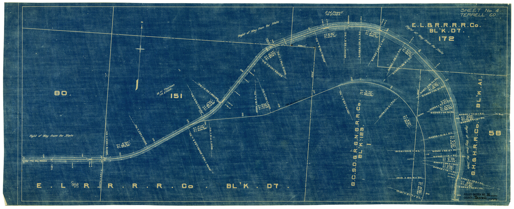
[Right of way through sections 80, 151, and 172, Block D-7, E. L. & R. R. R.R. Co., section 1, Block 123, G. C. S. D & R. G. N. G. R.R. Co., and section 58, Block A-1, G. H. & H. R.R. Co.]
-
Map/Doc
7978
-
Collection
General Map Collection
-
Counties
Terrell
-
Subjects
Surveying Rolled Sketch
-
Height x Width
13.8 x 33.4 inches
35.1 x 84.8 cm
-
Medium
blueprint/diazo
Part of: General Map Collection
Upton County Rolled Sketch 59

Print $40.00
- Digital $50.00
Upton County Rolled Sketch 59
Size 37.8 x 48.4 inches
Map/Doc 10062
Fisher County Boundary File 3

Print $32.00
- Digital $50.00
Fisher County Boundary File 3
Size 8.2 x 4.2 inches
Map/Doc 53428
Lee County Rolled Sketch 2

Print $20.00
- Digital $50.00
Lee County Rolled Sketch 2
1976
Size 25.9 x 34.4 inches
Map/Doc 6593
Brown County Working Sketch 14

Print $20.00
- Digital $50.00
Brown County Working Sketch 14
1989
Size 20.1 x 21.3 inches
Map/Doc 67779
Childress County Sketch File 16b

Print $6.00
- Digital $50.00
Childress County Sketch File 16b
1884
Size 12.6 x 8.1 inches
Map/Doc 18305
Brewster County Sketch File N-12

Print $4.00
- Digital $50.00
Brewster County Sketch File N-12
1933
Size 14.3 x 9.0 inches
Map/Doc 15623
Uvalde County Working Sketch 33

Print $20.00
- Digital $50.00
Uvalde County Working Sketch 33
1963
Size 24.5 x 39.2 inches
Map/Doc 72103
Brewster County Sketch File N-29

Print $6.00
- Digital $50.00
Brewster County Sketch File N-29
1969
Size 14.1 x 8.8 inches
Map/Doc 15705
Runnels County Sketch File 17

Print $6.00
Runnels County Sketch File 17
Size 11.0 x 13.6 inches
Map/Doc 35474
General Chart of the Coast No. XVI - Gulf Coast from Galveston to the Rio Grande

Print $20.00
- Digital $50.00
General Chart of the Coast No. XVI - Gulf Coast from Galveston to the Rio Grande
1883
Size 26.8 x 18.1 inches
Map/Doc 72737
Angelina County Working Sketch 51

Print $20.00
- Digital $50.00
Angelina County Working Sketch 51
1988
Size 44.0 x 23.0 inches
Map/Doc 67135
Glasscock County Rolled Sketch 3

Print $20.00
- Digital $50.00
Glasscock County Rolled Sketch 3
1906
Size 19.0 x 13.7 inches
Map/Doc 6014
You may also like
Sterling County Rolled Sketch 31

Print $40.00
- Digital $50.00
Sterling County Rolled Sketch 31
Size 40.9 x 92.6 inches
Map/Doc 9956

Glasscock County Boundary File 1

Print $18.00
- Digital $50.00
Glasscock County Boundary File 1
Size 14.4 x 9.0 inches
Map/Doc 53781
[Block 1, Section 31]
![92171, [Block 1, Section 31], Twichell Survey Records](https://historictexasmaps.com/wmedia_w700/maps/92171-1.tif.jpg)
Print $20.00
- Digital $50.00
[Block 1, Section 31]
1946
Size 24.3 x 19.7 inches
Map/Doc 92171
Flight Mission No. DQN-5K, Frame 32, Calhoun County

Print $20.00
- Digital $50.00
Flight Mission No. DQN-5K, Frame 32, Calhoun County
1953
Size 16.5 x 16.3 inches
Map/Doc 84383
Crockett County Working Sketch 39

Print $20.00
- Digital $50.00
Crockett County Working Sketch 39
1928
Size 14.7 x 22.2 inches
Map/Doc 68372
The Kennedy and Pringle Colony. February 15, 1842

Print $20.00
The Kennedy and Pringle Colony. February 15, 1842
2020
Size 23.0 x 17.7 inches
Map/Doc 96367
[Gulf, Colorado & Santa Fe]
![64576, [Gulf, Colorado & Santa Fe], General Map Collection](https://historictexasmaps.com/wmedia_w700/maps/64576.tif.jpg)
Print $40.00
- Digital $50.00
[Gulf, Colorado & Santa Fe]
Size 32.4 x 84.9 inches
Map/Doc 64576
Duval County Working Sketch 20

Print $20.00
- Digital $50.00
Duval County Working Sketch 20
1940
Size 20.5 x 12.7 inches
Map/Doc 68733
Dimmit County Rolled Sketch 9

Print $20.00
- Digital $50.00
Dimmit County Rolled Sketch 9
1941
Size 37.8 x 39.3 inches
Map/Doc 8796
Potter County Boundary File 5b

Print $22.00
- Digital $50.00
Potter County Boundary File 5b
Size 4.1 x 4.9 inches
Map/Doc 58025
Nueces County NRC Article 33.136 Sketch 16

Print $68.00
- Digital $50.00
Nueces County NRC Article 33.136 Sketch 16
2012
Size 22.0 x 17.0 inches
Map/Doc 94804