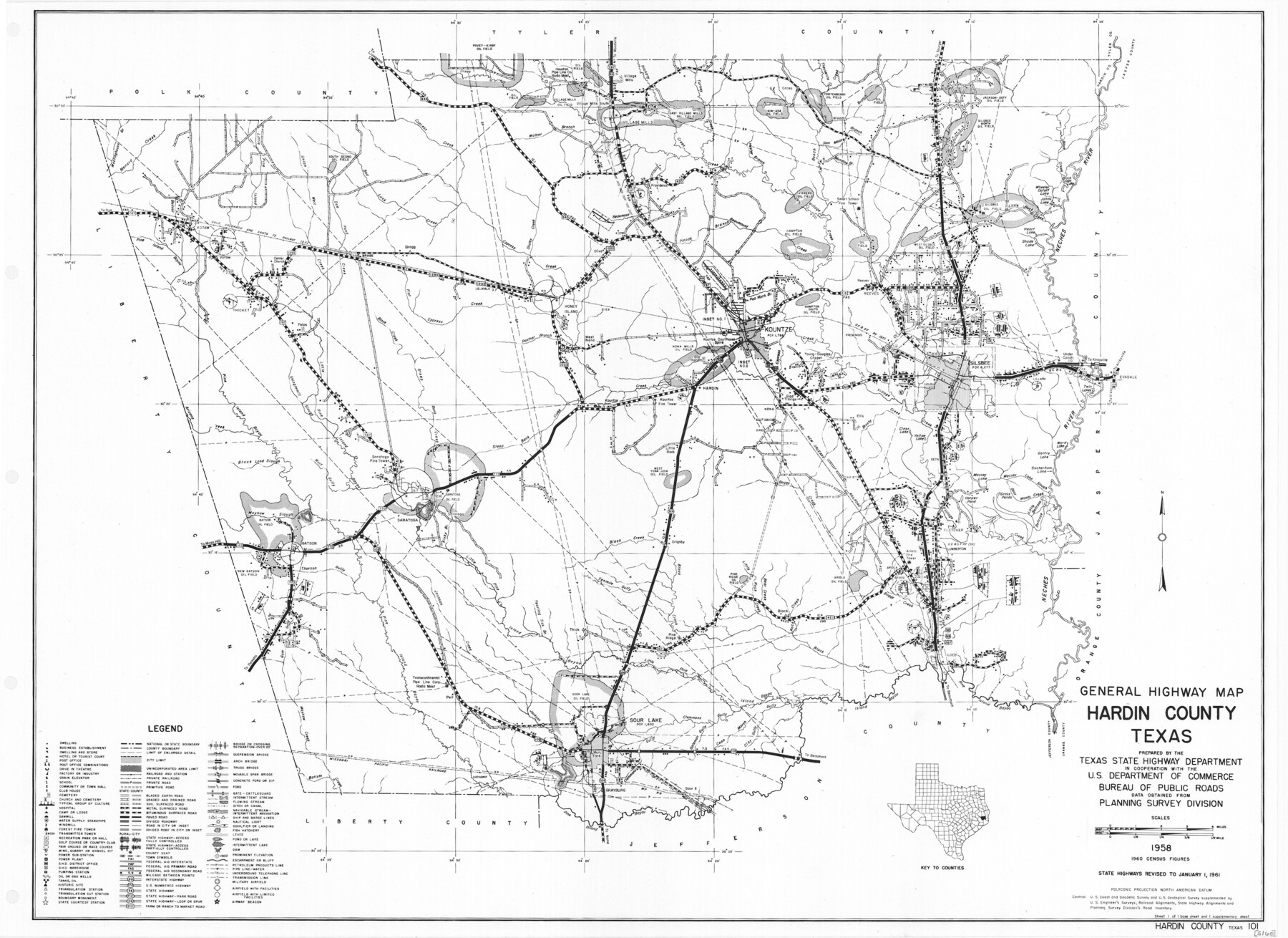
General Highway Map, Hardin County, Texas
-
Map/Doc
79499
-
Collection
Texas State Library and Archives
-
Object Dates
1961 (Creation Date)
-
People and Organizations
Texas State Highway Department (Publisher)
-
Counties
Hardin
-
Subjects
County
-
Height x Width
18.1 x 24.9 inches
46.0 x 63.3 cm
-
Comments
Prints available courtesy of the Texas State Library and Archives.
More info can be found here: TSLAC Map 05160
Part of: Texas State Library and Archives
General Highway Map, Bowie County, Texas

Print $20.00
General Highway Map, Bowie County, Texas
1940
Size 18.4 x 24.9 inches
Map/Doc 79023
General Highway Map, Oldham County, Texas

Print $20.00
General Highway Map, Oldham County, Texas
1961
Size 24.5 x 18.1 inches
Map/Doc 79619
Map of the City of San Antonio

Print $20.00
Map of the City of San Antonio
1909
Size 28.3 x 28.6 inches
Map/Doc 76293
General Highway Map, Brazoria County, Texas

Print $20.00
General Highway Map, Brazoria County, Texas
1939
Size 18.4 x 24.9 inches
Map/Doc 79025
General Highway Map, Fayette County, Texas

Print $20.00
General Highway Map, Fayette County, Texas
1940
Size 18.5 x 25.0 inches
Map/Doc 79089
General Highway Map, Zapata County, Texas

Print $20.00
General Highway Map, Zapata County, Texas
1961
Size 18.0 x 24.7 inches
Map/Doc 79722
General Highway Map, Starr County, Texas

Print $20.00
General Highway Map, Starr County, Texas
1961
Size 25.1 x 18.3 inches
Map/Doc 79659
General Highway Map, Jefferson County, Texas

Print $20.00
General Highway Map, Jefferson County, Texas
1961
Size 24.6 x 18.3 inches
Map/Doc 79537
Military Reconnaissance of the Arkansas, Rio Del Norte, and Rio Gila

Print $40.00
Military Reconnaissance of the Arkansas, Rio Del Norte, and Rio Gila
1847
Size 33.3 x 72.6 inches
Map/Doc 76240
General Highway Map, Sabine County, Texas

Print $20.00
General Highway Map, Sabine County, Texas
1940
Size 24.9 x 18.4 inches
Map/Doc 79234
General Highway Map, Henderson County, Texas

Print $20.00
General Highway Map, Henderson County, Texas
1961
Size 24.8 x 18.2 inches
Map/Doc 79516
General Highway Map, El Paso County, Texas

Print $20.00
General Highway Map, El Paso County, Texas
1961
Size 18.2 x 24.7 inches
Map/Doc 79454
You may also like
Map of Hamilton County

Print $20.00
- Digital $50.00
Map of Hamilton County
1872
Size 15.1 x 22.1 inches
Map/Doc 4555
Official Railroad and County Map of Texas

Print $40.00
Official Railroad and County Map of Texas
1914
Size 45.8 x 48.6 inches
Map/Doc 76233
Wheeler County Working Sketch 7

Print $40.00
- Digital $50.00
Wheeler County Working Sketch 7
1972
Size 50.1 x 42.9 inches
Map/Doc 72496
North Part Brewster Co.

Print $20.00
- Digital $50.00
North Part Brewster Co.
1914
Size 38.7 x 47.8 inches
Map/Doc 16948
Cameron County Rolled Sketch Z2

Print $20.00
- Digital $50.00
Cameron County Rolled Sketch Z2
1937
Size 23.7 x 40.9 inches
Map/Doc 5402
Fort Bend County Working Sketch 21

Print $20.00
- Digital $50.00
Fort Bend County Working Sketch 21
Size 26.9 x 28.6 inches
Map/Doc 69227
Flight Mission No. CGI-1N, Frame 177, Cameron County

Print $20.00
- Digital $50.00
Flight Mission No. CGI-1N, Frame 177, Cameron County
1955
Size 18.5 x 17.6 inches
Map/Doc 84512
Nacogdoches County Working Sketch 6

Print $20.00
- Digital $50.00
Nacogdoches County Working Sketch 6
1955
Size 14.7 x 12.5 inches
Map/Doc 71222
Starr County Sketch File D

Print $8.00
- Digital $50.00
Starr County Sketch File D
1892
Size 14.2 x 8.7 inches
Map/Doc 36915
Hood County Working Sketch 2

Print $20.00
- Digital $50.00
Hood County Working Sketch 2
1956
Size 20.5 x 25.5 inches
Map/Doc 66196
Hamilton County Working Sketch 2

Print $20.00
- Digital $50.00
Hamilton County Working Sketch 2
1923
Size 12.9 x 15.7 inches
Map/Doc 63340
Travis County Working Sketch 40

Print $20.00
- Digital $50.00
Travis County Working Sketch 40
1974
Size 31.7 x 32.1 inches
Map/Doc 69424