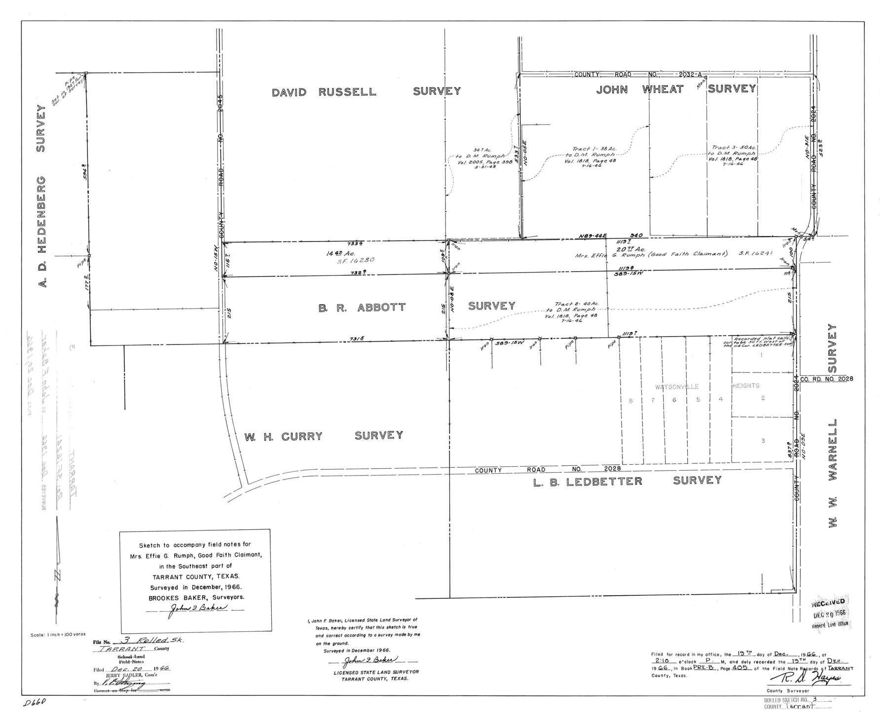
Tarrant County Rolled Sketch 3
Sketch to accompany field notes for Mrs. Effie G. Rumph, Good Faith Claimant, in the southeast part of Tarrant County, Texas
-
Map/Doc
7910
-
Collection
General Map Collection
-
Object Dates
1966 (Survey Date)
1966/12/20 (File Date)
-
People and Organizations
John F. Baker (Surveyor/Engineer)
-
Counties
Tarrant
-
Subjects
Surveying Rolled Sketch
-
Height x Width
23.3 x 28.6 inches
59.2 x 72.6 cm
-
Scale
1" = 100 varas
Part of: General Map Collection
Erath County Working Sketch 46

Print $40.00
- Digital $50.00
Erath County Working Sketch 46
1983
Size 49.6 x 43.1 inches
Map/Doc 69127
Dimmit County Sketch File 19 1/2

Print $40.00
- Digital $50.00
Dimmit County Sketch File 19 1/2
Size 16.6 x 13.9 inches
Map/Doc 21092

Terry County Sketch File 5

Print $40.00
- Digital $50.00
Terry County Sketch File 5
1916
Size 15.6 x 58.6 inches
Map/Doc 10391
Stonewall County Working Sketch 35

Print $20.00
- Digital $50.00
Stonewall County Working Sketch 35
1991
Size 41.1 x 33.0 inches
Map/Doc 62342
Wilbarger County Sketch File A

Print $6.00
- Digital $50.00
Wilbarger County Sketch File A
Size 8.3 x 14.1 inches
Map/Doc 40231
Travis County Sketch File 56

Print $6.00
- Digital $50.00
Travis County Sketch File 56
1945
Size 14.2 x 9.0 inches
Map/Doc 38398
Hutchinson County

Print $20.00
- Digital $50.00
Hutchinson County
1922
Size 40.7 x 34.8 inches
Map/Doc 77321
Wise County Sketch File 24

Print $4.00
- Digital $50.00
Wise County Sketch File 24
1860
Size 12.3 x 7.8 inches
Map/Doc 40570
Map of Falls County

Print $20.00
- Digital $50.00
Map of Falls County
1874
Size 20.3 x 21.5 inches
Map/Doc 3528
Sabine County Working Sketch 2

Print $3.00
- Digital $50.00
Sabine County Working Sketch 2
1906
Size 12.5 x 10.8 inches
Map/Doc 63673
No. 1. Outline Map of the Rio Grande from its mouth up to Ringold Barracks

Print $20.00
- Digital $50.00
No. 1. Outline Map of the Rio Grande from its mouth up to Ringold Barracks
Size 24.5 x 18.3 inches
Map/Doc 72858
You may also like
Sketch Showing Property Lines of Harlem State Farm

Print $20.00
- Digital $50.00
Sketch Showing Property Lines of Harlem State Farm
Size 16.0 x 30.2 inches
Map/Doc 62982
San Patricio County Working Sketch 19

Print $20.00
- Digital $50.00
San Patricio County Working Sketch 19
1956
Size 36.1 x 41.3 inches
Map/Doc 63781
Jeff Davis County Sketch File 26 1/2

Print $10.00
- Digital $50.00
Jeff Davis County Sketch File 26 1/2
Size 9.0 x 10.4 inches
Map/Doc 27999
Eastland County Working Sketch 4

Print $20.00
- Digital $50.00
Eastland County Working Sketch 4
1918
Size 39.1 x 29.1 inches
Map/Doc 68785
Ward County Rolled Sketch 24E

Print $40.00
- Digital $50.00
Ward County Rolled Sketch 24E
1967
Size 42.3 x 64.9 inches
Map/Doc 10116
[Surveying Sketch of W.B. Tatum, Wm. B. Jordan, et al]
![428, [Surveying Sketch of W.B. Tatum, Wm. B. Jordan, et al], Maddox Collection](https://historictexasmaps.com/wmedia_w700/maps/0428.tif.jpg)
Print $2.00
- Digital $50.00
[Surveying Sketch of W.B. Tatum, Wm. B. Jordan, et al]
Size 8.9 x 10.8 inches
Map/Doc 428
Flight Mission No. DQN-3K, Frame 33, Calhoun County

Print $20.00
- Digital $50.00
Flight Mission No. DQN-3K, Frame 33, Calhoun County
1953
Size 18.6 x 22.3 inches
Map/Doc 84346
Limestone County Working Sketch 3

Print $20.00
- Digital $50.00
Limestone County Working Sketch 3
1919
Size 28.9 x 28.5 inches
Map/Doc 70553
Pecos County Sketch File 27B

Print $20.00
- Digital $50.00
Pecos County Sketch File 27B
1908
Size 25.7 x 20.8 inches
Map/Doc 12167
Aransas County NRC Article 33.136 Location Key Sheet

Print $20.00
- Digital $50.00
Aransas County NRC Article 33.136 Location Key Sheet
1971
Size 27.0 x 23.0 inches
Map/Doc 88769
Working Sketch in Stephens-Palo Pinto Cos.

Print $20.00
- Digital $50.00
Working Sketch in Stephens-Palo Pinto Cos.
1919
Size 22.3 x 13.3 inches
Map/Doc 91918
Jack County Working Sketch 13

Print $20.00
- Digital $50.00
Jack County Working Sketch 13
1975
Size 25.5 x 35.8 inches
Map/Doc 66439