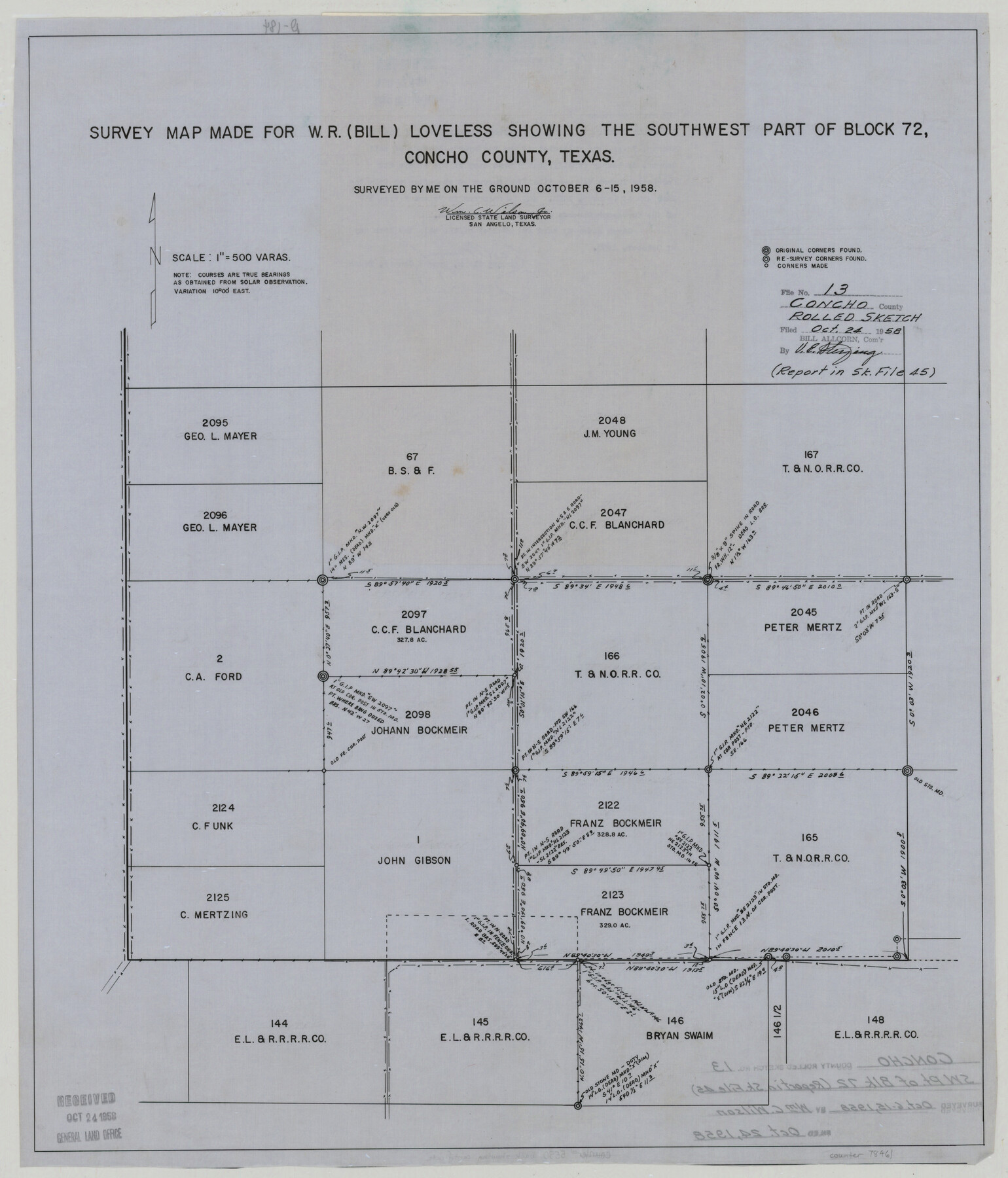
Concho County Rolled Sketch 13
Survey map made for W.R. (Bill) Loveless showing the southwest part of Block 72, Concho County, Texas
-
Map/Doc
78461
-
Collection
General Map Collection
-
Object Dates
1958/10/15 (Creation Date)
1958/10/24 (File Date)
-
People and Organizations
Wm. C. Wilson, Jr. (Surveyor/Engineer)
-
Counties
Concho
-
Subjects
Surveying Rolled Sketch
-
Height x Width
23.7 x 20.3 inches
60.2 x 51.6 cm
-
Medium
linen, manuscript
-
Scale
1" = 500 varas
-
Comments
See Concho County Sketch File 45 (19210) for surveyor’s report.
Related maps
Concho County Sketch File 45

Print $6.00
- Digital $50.00
Concho County Sketch File 45
1958
Size 11.2 x 8.8 inches
Map/Doc 19210
Part of: General Map Collection
Upshur County Working Sketch 15, revised

Print $20.00
- Digital $50.00
Upshur County Working Sketch 15, revised
1996
Size 43.3 x 37.4 inches
Map/Doc 78217
Padre Island National Seashore

Print $4.00
- Digital $50.00
Padre Island National Seashore
Size 16.0 x 21.8 inches
Map/Doc 60527
Ochiltree County Sketch File 12

Print $24.00
- Digital $50.00
Ochiltree County Sketch File 12
1990
Size 11.2 x 8.5 inches
Map/Doc 33201
Bandera County Working Sketch 24

Print $20.00
- Digital $50.00
Bandera County Working Sketch 24
1950
Size 31.6 x 33.0 inches
Map/Doc 67620
Cooke County Working Sketch 6

Print $20.00
- Digital $50.00
Cooke County Working Sketch 6
1935
Size 21.4 x 22.1 inches
Map/Doc 68243
Bandera County Working Sketch 2

Print $20.00
- Digital $50.00
Bandera County Working Sketch 2
Size 23.1 x 24.6 inches
Map/Doc 67595
Menard County Working Sketch 1

Print $20.00
- Digital $50.00
Menard County Working Sketch 1
1905
Size 23.3 x 18.9 inches
Map/Doc 70948
Palo Pinto County Working Sketch 27

Print $20.00
- Digital $50.00
Palo Pinto County Working Sketch 27
2006
Map/Doc 83609

Sutton County Working Sketch 24

Print $20.00
- Digital $50.00
Sutton County Working Sketch 24
1985
Size 32.6 x 42.5 inches
Map/Doc 62367
Brewster County Sketch File N-20

Print $40.00
- Digital $50.00
Brewster County Sketch File N-20
1941
Size 16.5 x 20.5 inches
Map/Doc 10967
Texas, Matagorda Bay, Liveoak Bay

Print $40.00
- Digital $50.00
Texas, Matagorda Bay, Liveoak Bay
1933
Size 32.5 x 48.9 inches
Map/Doc 69992
You may also like

Brewster County Rolled Sketch 104

Print $40.00
- Digital $50.00
Brewster County Rolled Sketch 104
1938
Size 68.3 x 45.3 inches
Map/Doc 8511
Travis County Sketch File 69

Print $6.00
- Digital $50.00
Travis County Sketch File 69
1955
Size 14.3 x 8.9 inches
Map/Doc 38451
Nueces County Rolled Sketch 106

Print $104.00
Nueces County Rolled Sketch 106
1986
Size 18.2 x 24.6 inches
Map/Doc 7097
Calhoun County Working Sketch 3

Print $20.00
- Digital $50.00
Calhoun County Working Sketch 3
1923
Size 18.4 x 42.4 inches
Map/Doc 67819
Val Verde County Working Sketch 121

Print $40.00
- Digital $50.00
Val Verde County Working Sketch 121
2005
Size 34.0 x 54.2 inches
Map/Doc 83590
McLennan County Sketch File 25

Print $2.00
- Digital $50.00
McLennan County Sketch File 25
Size 8.8 x 12.3 inches
Map/Doc 31299
Flight Mission No. BRA-7M, Frame 127, Jefferson County

Print $20.00
- Digital $50.00
Flight Mission No. BRA-7M, Frame 127, Jefferson County
1953
Size 18.5 x 22.3 inches
Map/Doc 85521
[Leagues 139 and 130]
![90440, [Leagues 139 and 130], Twichell Survey Records](https://historictexasmaps.com/wmedia_w700/maps/90440-1.tif.jpg)
Print $2.00
- Digital $50.00
[Leagues 139 and 130]
Size 7.9 x 12.5 inches
Map/Doc 90440
Nueces County Sketch File 47

Print $17.00
- Digital $50.00
Nueces County Sketch File 47
Size 14.3 x 8.5 inches
Map/Doc 32655
Presidio County Rolled Sketch 138

Print $20.00
- Digital $50.00
Presidio County Rolled Sketch 138
2000
Size 36.7 x 25.1 inches
Map/Doc 7405
