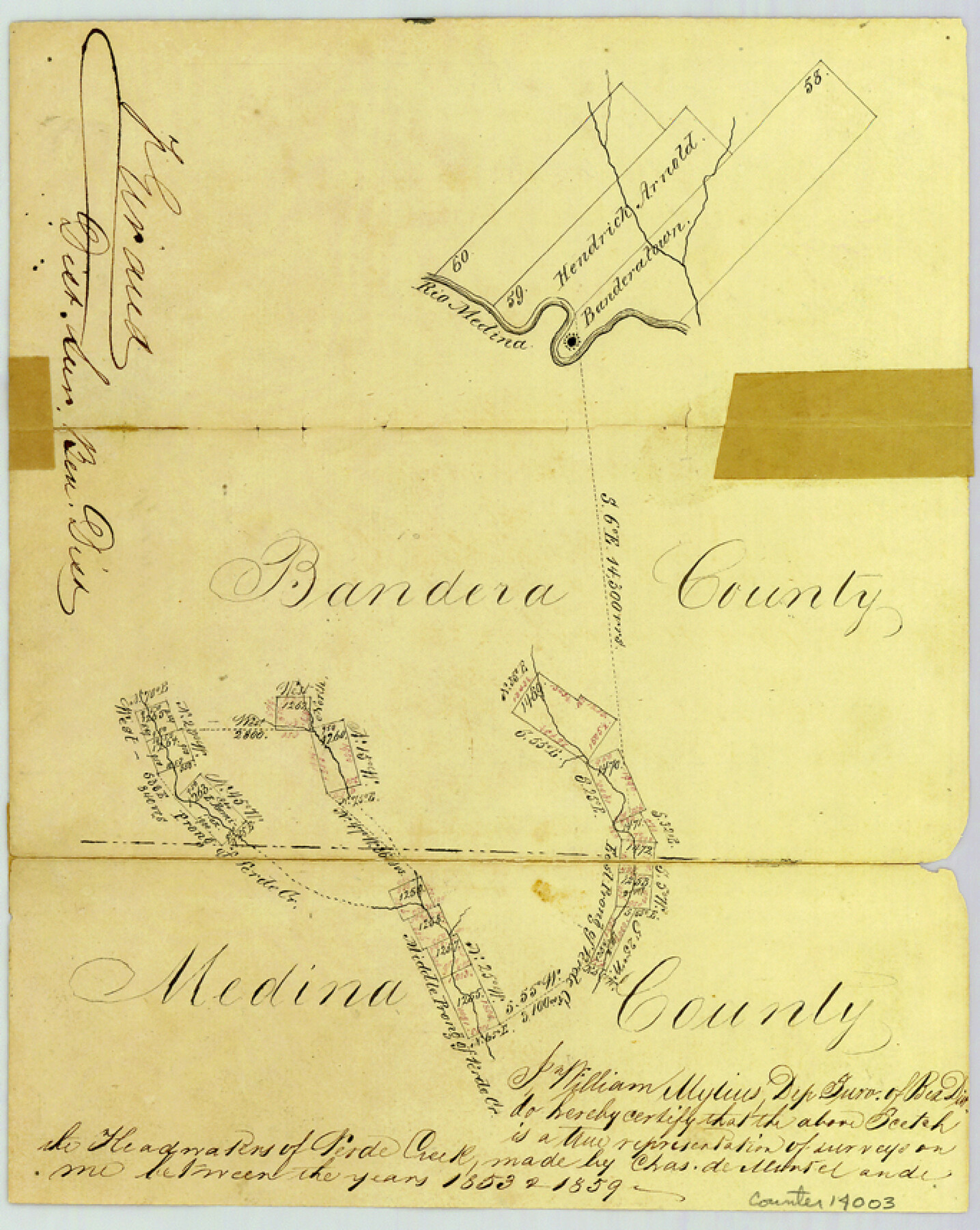
Bandera County Sketch File 5
[Sketch south of Bandera along Verde Creek near Bandera-Medina county line]
-
Map/Doc
14003
-
Collection
General Map Collection
-
Object Dates
1858/5/10 (File Date)
-
People and Organizations
Chas. de Montel (Surveyor/Engineer)
William Mylius (Surveyor/Engineer)
-
Counties
Bandera
-
Subjects
Surveying Sketch File
-
Height x Width
8.6 x 6.8 inches
21.8 x 17.3 cm
-
Medium
paper, manuscript
-
Features
Rio Medina
West Prong of Verde Creek
East Prong of Verde Creek
Middle Prong of Verde Creek
Part of: General Map Collection
Marion County Sketch File 1a

Print $3.00
- Digital $50.00
Marion County Sketch File 1a
1867
Size 17.4 x 7.7 inches
Map/Doc 30559
Nueces County Rolled Sketch 88

Print $20.00
- Digital $50.00
Nueces County Rolled Sketch 88
1983
Size 18.4 x 24.6 inches
Map/Doc 6990
Texas, Copano Bay, Mission Bay and Fish Point

Print $40.00
- Digital $50.00
Texas, Copano Bay, Mission Bay and Fish Point
1934
Size 33.3 x 48.9 inches
Map/Doc 73433
Flight Mission No. BRE-2P, Frame 65, Nueces County

Print $20.00
- Digital $50.00
Flight Mission No. BRE-2P, Frame 65, Nueces County
1956
Size 18.4 x 22.3 inches
Map/Doc 86760
Palo Pinto County Boundary File 4

Print $17.00
- Digital $50.00
Palo Pinto County Boundary File 4
Size 9.0 x 8.4 inches
Map/Doc 57811
Nueces County Rolled Sketch 127 A-F

Print $22.00
Nueces County Rolled Sketch 127 A-F
1998
Size 11.1 x 26.6 inches
Map/Doc 8976
Sutton County Sketch File 27B

Print $20.00
- Digital $50.00
Sutton County Sketch File 27B
Size 19.1 x 14.6 inches
Map/Doc 12384
Upton County Sketch File 11

Print $20.00
- Digital $50.00
Upton County Sketch File 11
1919
Size 22.5 x 27.6 inches
Map/Doc 12511
Hardeman County Sketch File 2

Print $6.00
- Digital $50.00
Hardeman County Sketch File 2
1879
Size 9.0 x 7.7 inches
Map/Doc 24984
Medina County Rolled Sketch 15

Print $20.00
- Digital $50.00
Medina County Rolled Sketch 15
1980
Size 25.2 x 20.3 inches
Map/Doc 6749
Flight Mission No. CRC-4R, Frame 107, Chambers County

Print $20.00
- Digital $50.00
Flight Mission No. CRC-4R, Frame 107, Chambers County
1956
Size 18.8 x 22.4 inches
Map/Doc 84904
El Paso County Sketch File 29

Print $14.00
- Digital $50.00
El Paso County Sketch File 29
1949
Size 14.5 x 9.4 inches
Map/Doc 22076
You may also like
Stephens County Working Sketch 31

Print $20.00
- Digital $50.00
Stephens County Working Sketch 31
1978
Size 41.9 x 30.8 inches
Map/Doc 63974
Duval County Boundary File 3

Print $14.00
- Digital $50.00
Duval County Boundary File 3
Size 8.6 x 3.9 inches
Map/Doc 52719
Starr County Rolled Sketch 29

Print $20.00
- Digital $50.00
Starr County Rolled Sketch 29
1857
Size 35.1 x 30.0 inches
Map/Doc 7812
Sutton County Rolled Sketch 57

Print $40.00
- Digital $50.00
Sutton County Rolled Sketch 57
1958
Size 40.1 x 51.1 inches
Map/Doc 10662
Reagan County Rolled Sketch 17

Print $20.00
- Digital $50.00
Reagan County Rolled Sketch 17
Size 34.8 x 32.9 inches
Map/Doc 9812
Maps of Gulf Intracoastal Waterway, Texas - Sabine River to the Rio Grande and connecting waterways including ship channels

Print $20.00
- Digital $50.00
Maps of Gulf Intracoastal Waterway, Texas - Sabine River to the Rio Grande and connecting waterways including ship channels
1966
Size 14.6 x 20.8 inches
Map/Doc 61995
Uvalde County Sketch File 6

Print $20.00
- Digital $50.00
Uvalde County Sketch File 6
Size 25.0 x 31.4 inches
Map/Doc 12526
Colorado River, Buecher State Park

Print $4.00
- Digital $50.00
Colorado River, Buecher State Park
1934
Size 20.8 x 11.6 inches
Map/Doc 65324
Corpus Christi Harbor

Print $40.00
- Digital $50.00
Corpus Christi Harbor
1976
Size 37.1 x 51.5 inches
Map/Doc 73480
Amistad International Reservoir on Rio Grande 71a

Print $20.00
- Digital $50.00
Amistad International Reservoir on Rio Grande 71a
1949
Size 28.4 x 39.6 inches
Map/Doc 73359
C No. 3 - Sea Coast of Delaware, Maryland, and part of Virginia

Print $20.00
- Digital $50.00
C No. 3 - Sea Coast of Delaware, Maryland, and part of Virginia
1852
Size 30.4 x 22.2 inches
Map/Doc 97207
Irion County Working Sketch 1

Print $20.00
- Digital $50.00
Irion County Working Sketch 1
Size 24.3 x 26.8 inches
Map/Doc 66410