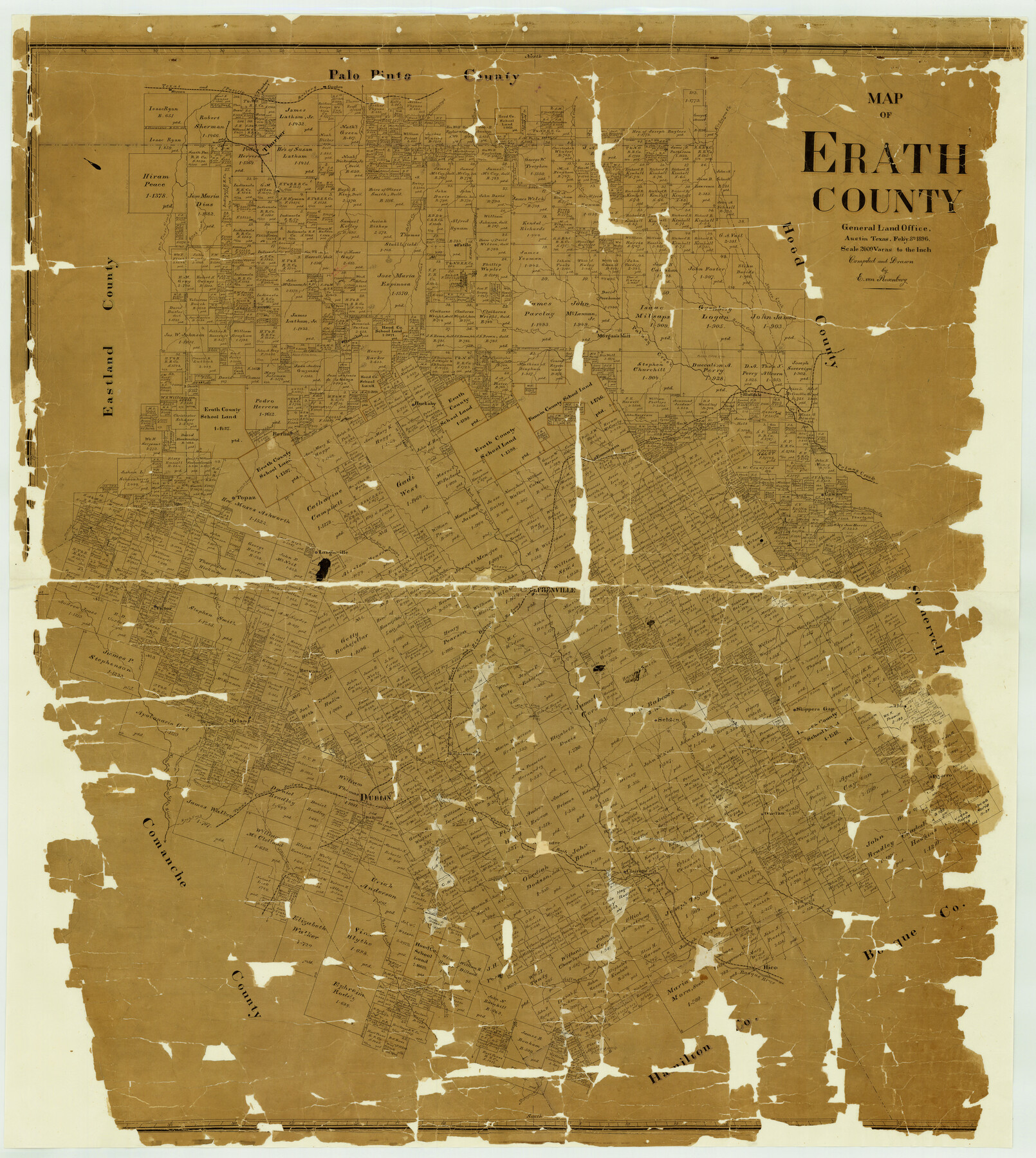
Map of Erath County
-
Map/Doc
7820
-
Collection
General Map Collection
-
Object Dates
1896/2/8 (Creation Date)
-
People and Organizations
Texas General Land Office (Publisher)
E. von Rosenberg (Draftsman)
E. von Rosenberg (Compiler)
-
Counties
Erath
-
Subjects
County
-
Height x Width
50.4 x 45.1 inches
128.0 x 114.6 cm
-
Comments
Conservation funded in 2001 with donation from Heart of Texas Chapter 21, Texas Society of Professional Surveyors (TSPS).
-
Features
Village Creek
Cottonwood Creek
Dublin
TCRR
Walker Creek
North Fork of Leon River
Scott's Creek
Hyland Creek
Green's Creek
Armstrong's Creek
Duffau
West Fork of Green's Creek
Harbin
West Fork of Duffau Creek
East Fork of Duffau Creek
Selden
Duffau Creek
Skippers Gap
FW&RG
Flat Creek
Four Mile Creek
Twin Mountains
Thompson's Creek
Spring Branch
Heavenly Branch of Green's Creek
Old Indian Village
Alarm Creek
Hyland
North Fork of Bosque River
Honey Creek
Victor
Gillmour's [sic] Creek
Bosque River
Hico
Clairette
Little Green Creek
Little Walnut Creek
Rush Creek
Old Dublin
Pizarro
Palo Pinto Creek
South Paluxy Creek
Bluffdale
Morgan's Mill
Hannibal
Paluxy Creek
Berrys Creek
Allcorn Creek
Patilo
Resley's Creek
Huckaby
Thurber
Kickapoo Creek
Sunday's Creek
Saline Creek
Buck Creek
Bartons Creek
Gordon
T&P
Ice Creek
Strawn
Stephenville
Sycamore Creek
Big Kid Branch Creek
West Fork of Bosque River
Linghville
Hog Creek
Pony Creek
Black Creek
Richardson's Creek
Thurber Junction
Cowan
Head's Creek
Bunyan
Emmurmen
East Fork of Bosque River
Topaz
Leon River
Prong of Leon River
Berlin
Part of: General Map Collection
Flight Mission No. BRA-7M, Frame 27, Jefferson County

Print $20.00
- Digital $50.00
Flight Mission No. BRA-7M, Frame 27, Jefferson County
1953
Size 18.5 x 22.3 inches
Map/Doc 85478

Anderson County Sketch File 9

Print $8.00
- Digital $50.00
Anderson County Sketch File 9
Size 12.5 x 8.2 inches
Map/Doc 12761
Ector County Working Sketch 4

Print $20.00
- Digital $50.00
Ector County Working Sketch 4
1940
Size 25.8 x 30.0 inches
Map/Doc 68847
Edwards County Sketch File 12

Print $16.00
- Digital $50.00
Edwards County Sketch File 12
Size 14.6 x 9.1 inches
Map/Doc 21690
Shelby County Working Sketch 30

Print $20.00
- Digital $50.00
Shelby County Working Sketch 30
2000
Size 35.9 x 44.7 inches
Map/Doc 63885
S.P.O. Co. No. 7, State Submerged Tract No. 12, Laguna Madre, Nueces Co., Texas

Print $20.00
- Digital $50.00
S.P.O. Co. No. 7, State Submerged Tract No. 12, Laguna Madre, Nueces Co., Texas
1937
Size 27.9 x 27.4 inches
Map/Doc 3026
Stephens County Sketch File 1

Print $20.00
- Digital $50.00
Stephens County Sketch File 1
1857
Size 19.2 x 16.1 inches
Map/Doc 12347
Head of Cowhouse Cr.

Print $2.00
- Digital $50.00
Head of Cowhouse Cr.
1846
Size 6.4 x 13.7 inches
Map/Doc 271
No. 3 Chart of Channel connecting Corpus Christi Bay with Aransas Bay, Texas

Print $20.00
- Digital $50.00
No. 3 Chart of Channel connecting Corpus Christi Bay with Aransas Bay, Texas
1878
Size 18.4 x 28.0 inches
Map/Doc 72771
Briscoe County Sketch File F

Print $40.00
- Digital $50.00
Briscoe County Sketch File F
1917
Size 20.9 x 19.3 inches
Map/Doc 76756
Matagorda County Working Sketch 15

Print $40.00
- Digital $50.00
Matagorda County Working Sketch 15
1954
Size 49.3 x 44.5 inches
Map/Doc 70873
You may also like
Hood County Working Sketch 4

Print $20.00
- Digital $50.00
Hood County Working Sketch 4
1967
Size 31.6 x 36.6 inches
Map/Doc 66198
Right of Way and Track Map of The Missouri, Kansas & Texas Railway of Texas

Print $40.00
- Digital $50.00
Right of Way and Track Map of The Missouri, Kansas & Texas Railway of Texas
1918
Size 24.8 x 53.4 inches
Map/Doc 64534
Bee County Working Sketch 19

Print $20.00
- Digital $50.00
Bee County Working Sketch 19
1980
Size 17.3 x 11.9 inches
Map/Doc 67269
Flight Mission No. BRA-8M, Frame 118, Jefferson County

Print $20.00
- Digital $50.00
Flight Mission No. BRA-8M, Frame 118, Jefferson County
1953
Size 18.6 x 22.3 inches
Map/Doc 85614
Nacogdoches Co.

Print $40.00
- Digital $50.00
Nacogdoches Co.
1905
Size 48.6 x 43.4 inches
Map/Doc 66949
Amistad International Reservoir on Rio Grande 74a

Print $20.00
- Digital $50.00
Amistad International Reservoir on Rio Grande 74a
1949
Size 28.6 x 40.0 inches
Map/Doc 75502
[H. & G. N. RR. Co. Block 1]
![90892, [H. & G. N. RR. Co. Block 1], Twichell Survey Records](https://historictexasmaps.com/wmedia_w700/maps/90892-1.tif.jpg)
Print $20.00
- Digital $50.00
[H. & G. N. RR. Co. Block 1]
1902
Size 14.9 x 15.8 inches
Map/Doc 90892
El Paso County Working Sketch 21

Print $20.00
- Digital $50.00
El Paso County Working Sketch 21
1960
Size 37.8 x 30.9 inches
Map/Doc 69043
Flight Mission No. DQN-5K, Frame 77, Calhoun County

Print $20.00
- Digital $50.00
Flight Mission No. DQN-5K, Frame 77, Calhoun County
1953
Size 18.5 x 22.1 inches
Map/Doc 84410
Atascosa County Rolled Sketch R

Print $20.00
- Digital $50.00
Atascosa County Rolled Sketch R
Size 19.6 x 19.6 inches
Map/Doc 5103
Map of the County of Cameron, Texas

Print $40.00
- Digital $50.00
Map of the County of Cameron, Texas
1884
Size 54.7 x 34.5 inches
Map/Doc 3141
Due Southwest over the Cotton Belt Route

Due Southwest over the Cotton Belt Route
1891
Map/Doc 96773