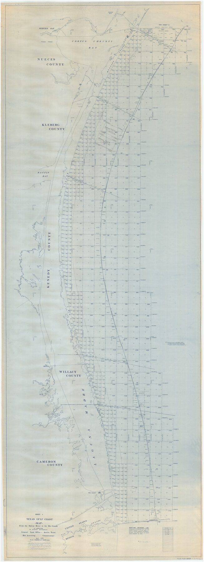
Texas Gulf Coast, from the Sabine River to the Rio Grande as Subdivided for Mineral Development; Aransas, Nueces, Kleberg, Kenedy, Willacy, and Cameron Counties
-
Map/Doc
1940
-
Collection
General Map Collection
-
Object Dates
1976 (Creation Date)
-
People and Organizations
General Land Office (Publisher)
-
Counties
Aransas Nueces Kleberg Kenedy Willacy Cameron
-
Subjects
Energy Offshore Submerged Area
-
Height x Width
118.0 x 43.0 inches
299.7 x 109.2 cm
-
Medium
tracing
-
Scale
2400 varas
-
Comments
Gulf coast and submerged state land.
Part of: General Map Collection
Coleman County Working Sketch 8

Print $20.00
- Digital $50.00
Coleman County Working Sketch 8
1946
Size 39.3 x 33.3 inches
Map/Doc 68074
Travis County Sketch File 65

Print $4.00
- Digital $50.00
Travis County Sketch File 65
1948
Size 9.1 x 9.1 inches
Map/Doc 38438
A Map of the Internal Provinces of New Spain

Print $20.00
- Digital $50.00
A Map of the Internal Provinces of New Spain
1810
Size 19.8 x 21.0 inches
Map/Doc 95156
Loving County Working Sketch 22

Print $20.00
- Digital $50.00
Loving County Working Sketch 22
1984
Size 18.3 x 34.9 inches
Map/Doc 70656
Concho County Sketch File 47

Print $20.00
- Digital $50.00
Concho County Sketch File 47
1950
Size 16.8 x 21.0 inches
Map/Doc 11165
Right of Way & Track Map, St. Louis, Brownsville & Mexico Ry. operated by St. Louis, Brownsville & Mexico Ry. Co.

Print $40.00
- Digital $50.00
Right of Way & Track Map, St. Louis, Brownsville & Mexico Ry. operated by St. Louis, Brownsville & Mexico Ry. Co.
1919
Size 25.7 x 57.6 inches
Map/Doc 64619
Live Oak County Working Sketch 12

Print $20.00
- Digital $50.00
Live Oak County Working Sketch 12
1949
Size 23.1 x 19.7 inches
Map/Doc 70597
Morris County Rolled Sketch 2A

Print $20.00
- Digital $50.00
Morris County Rolled Sketch 2A
Size 24.0 x 18.8 inches
Map/Doc 10254
Terrell County Working Sketch 73

Print $20.00
- Digital $50.00
Terrell County Working Sketch 73
1980
Size 29.0 x 47.5 inches
Map/Doc 69594
Flight Mission No. BRA-16M, Frame 162, Jefferson County

Print $20.00
- Digital $50.00
Flight Mission No. BRA-16M, Frame 162, Jefferson County
1953
Size 18.6 x 22.3 inches
Map/Doc 85760
Cochran County

Print $20.00
- Digital $50.00
Cochran County
1946
Size 30.8 x 23.1 inches
Map/Doc 77239
Flight Mission No. BRE-1P, Frame 75, Nueces County

Print $20.00
- Digital $50.00
Flight Mission No. BRE-1P, Frame 75, Nueces County
1956
Size 18.4 x 22.2 inches
Map/Doc 86657
You may also like
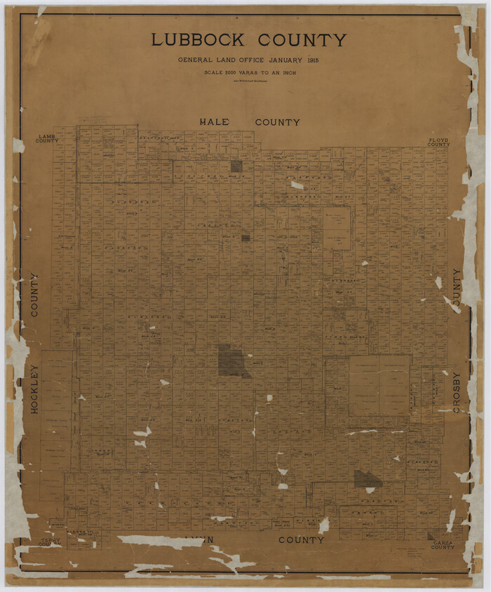
Lubbock County
Print $40.00
- Digital $50.00
Lubbock County
1915
Size 49.0 x 40.6 inches
Map/Doc 895
Station Map, the Missouri, Kansas and Texas Ry. Of Texas - Henrietta Division

Print $20.00
- Digital $50.00
Station Map, the Missouri, Kansas and Texas Ry. Of Texas - Henrietta Division
1918
Size 11.8 x 26.7 inches
Map/Doc 64763
Flight Mission No. BRE-2P, Frame 100, Nueces County

Print $20.00
- Digital $50.00
Flight Mission No. BRE-2P, Frame 100, Nueces County
1956
Size 18.5 x 22.3 inches
Map/Doc 86785
No. 1. Outline Map of the Rio Grande from its mouth up to Ringold Barracks

Print $20.00
- Digital $50.00
No. 1. Outline Map of the Rio Grande from its mouth up to Ringold Barracks
Size 24.5 x 18.3 inches
Map/Doc 72858

Flight Mission No. DCL-7C, Frame 40, Kenedy County

Print $20.00
- Digital $50.00
Flight Mission No. DCL-7C, Frame 40, Kenedy County
1943
Size 15.4 x 15.2 inches
Map/Doc 86028
English Field Notes of the Spanish Archives - Book 2

English Field Notes of the Spanish Archives - Book 2
1835
Map/Doc 96528

Webb County Boundary File 6

Print $123.00
- Digital $50.00
Webb County Boundary File 6
Size 14.4 x 8.8 inches
Map/Doc 59786
Harris County

Print $20.00
- Digital $50.00
Harris County
1940
Size 36.8 x 45.2 inches
Map/Doc 77304
General Highway Map. Detail of Cities and Towns in Grayson County, Texas [Denison and Sherman]
![79487, General Highway Map. Detail of Cities and Towns in Grayson County, Texas [Denison and Sherman], Texas State Library and Archives](https://historictexasmaps.com/wmedia_w700/maps/79487.tif.jpg)
Print $20.00
General Highway Map. Detail of Cities and Towns in Grayson County, Texas [Denison and Sherman]
1961
Size 18.2 x 24.6 inches
Map/Doc 79487
Flight Mission No. BRA-7M, Frame 205, Jefferson County

Print $20.00
- Digital $50.00
Flight Mission No. BRA-7M, Frame 205, Jefferson County
1953
Size 18.5 x 22.4 inches
Map/Doc 85573