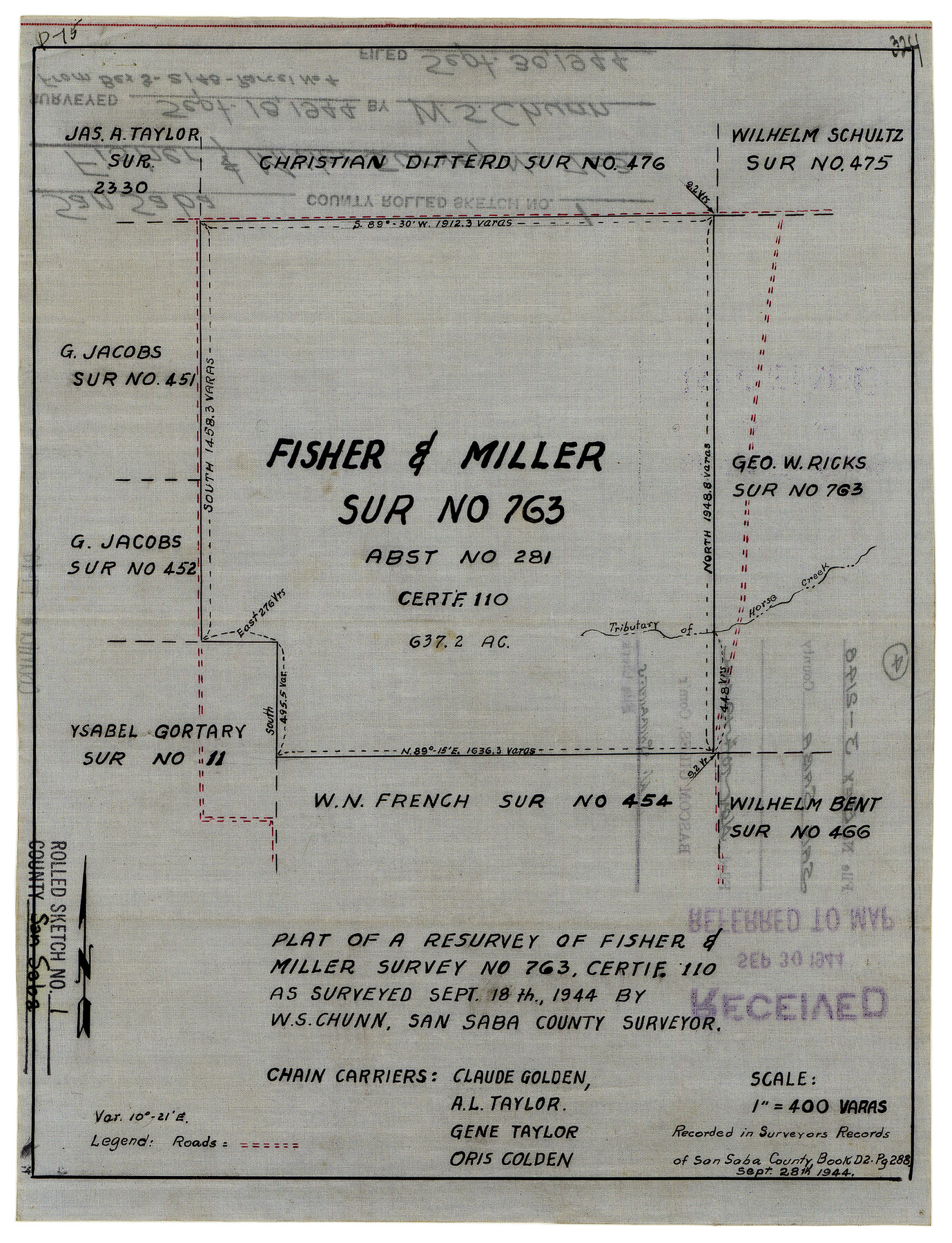
San Saba County Rolled Sketch 1
Plat of a resurvey of Fisher & Miller survey no. 763, certif. 110
-
Map/Doc
7742
-
Collection
General Map Collection
-
Object Dates
9/18/1944 (Survey Date)
9/30/1944 (File Date)
-
People and Organizations
W.S. Chunn (Surveyor/Engineer)
A.L. Taylor (Chainman/Field Personnel)
Gene Taylor (Chainman/Field Personnel)
Oris Colden (Chainman/Field Personnel)
-
Counties
San Saba
-
Subjects
Surveying Rolled Sketch
-
Height x Width
11.7 x 9.0 inches
29.7 x 22.9 cm
-
Medium
linen, manuscript
-
Scale
1" = 400 varas
Part of: General Map Collection
Baylor County Working Sketch 14

Print $40.00
- Digital $50.00
Baylor County Working Sketch 14
1982
Size 33.5 x 55.1 inches
Map/Doc 67299
Galveston County Working Sketch 24

Print $20.00
- Digital $50.00
Galveston County Working Sketch 24
1939
Size 16.6 x 19.6 inches
Map/Doc 69361
Corpus Christi Harbor

Print $40.00
- Digital $50.00
Corpus Christi Harbor
1976
Size 37.1 x 51.5 inches
Map/Doc 73480
Angelina County Working Sketch 10

Print $20.00
- Digital $50.00
Angelina County Working Sketch 10
1934
Size 35.0 x 36.9 inches
Map/Doc 67091
Flight Mission No. DIX-10P, Frame 146, Aransas County

Print $20.00
- Digital $50.00
Flight Mission No. DIX-10P, Frame 146, Aransas County
1956
Size 18.6 x 22.4 inches
Map/Doc 83948
Andrews County Rolled Sketch 46

Print $40.00
- Digital $50.00
Andrews County Rolled Sketch 46
2013
Size 52.0 x 36.0 inches
Map/Doc 93641
Mills County Boundary File 10

Print $46.00
- Digital $50.00
Mills County Boundary File 10
Size 17.0 x 11.6 inches
Map/Doc 57329
Medina County Working Sketch Graphic Index

Print $40.00
- Digital $50.00
Medina County Working Sketch Graphic Index
1976
Size 52.8 x 42.8 inches
Map/Doc 76639
Flight Mission No. DAH-10M, Frame 41, Orange County

Print $20.00
- Digital $50.00
Flight Mission No. DAH-10M, Frame 41, Orange County
1953
Size 18.7 x 22.5 inches
Map/Doc 86876
Webb County Sketch File 60

Print $8.00
- Digital $50.00
Webb County Sketch File 60
1943
Size 14.4 x 8.9 inches
Map/Doc 39855
Winkler County Working Sketch 6

Print $20.00
- Digital $50.00
Winkler County Working Sketch 6
1957
Size 34.5 x 31.5 inches
Map/Doc 72600
Liberty County Sketch File 22

Print $10.00
- Digital $50.00
Liberty County Sketch File 22
1860
Size 14.0 x 9.8 inches
Map/Doc 29930
You may also like
Titus County Working Sketch 1

Print $20.00
- Digital $50.00
Titus County Working Sketch 1
Size 18.2 x 17.3 inches
Map/Doc 69362
General Highway Map, Webb County, Texas

Print $20.00
General Highway Map, Webb County, Texas
1961
Size 18.2 x 24.8 inches
Map/Doc 79704
Archer County Sketch File 20

Print $6.00
- Digital $50.00
Archer County Sketch File 20
1936
Size 11.0 x 8.7 inches
Map/Doc 13655
Controlled Mosaic by Jack Amman Photogrammetric Engineers, Inc - Sheet 35

Print $20.00
- Digital $50.00
Controlled Mosaic by Jack Amman Photogrammetric Engineers, Inc - Sheet 35
1954
Size 20.0 x 24.0 inches
Map/Doc 83488
[Capitol Leagues 217, 218, 219 and 220]
![91460, [Capitol Leagues 217, 218, 219 and 220], Twichell Survey Records](https://historictexasmaps.com/wmedia_w700/maps/91460-1.tif.jpg)
Print $20.00
- Digital $50.00
[Capitol Leagues 217, 218, 219 and 220]
Size 23.2 x 10.3 inches
Map/Doc 91460
Presidio County Sketch File 84 1/2

Print $38.00
- Digital $50.00
Presidio County Sketch File 84 1/2
1949
Size 9.0 x 14.5 inches
Map/Doc 34726
![91458, [Capitol Land], Twichell Survey Records](https://historictexasmaps.com/wmedia_w700/maps/91458-1.tif.jpg)
Hansford County Working Sketch 2

Print $40.00
- Digital $50.00
Hansford County Working Sketch 2
1934
Size 42.7 x 54.4 inches
Map/Doc 63374
Kendall County Sketch File 18

Print $4.00
- Digital $50.00
Kendall County Sketch File 18
1882
Size 10.0 x 6.7 inches
Map/Doc 28711
[Sketch showing Blocks B-11, O-18, P and Mc in case of Laneer vs. Bivens]
![91727, [Sketch showing Blocks B-11, O-18, P and Mc in case of Laneer vs. Bivens], Twichell Survey Records](https://historictexasmaps.com/wmedia_w700/maps/91727-1.tif.jpg)
Print $20.00
- Digital $50.00
[Sketch showing Blocks B-11, O-18, P and Mc in case of Laneer vs. Bivens]
Size 20.9 x 18.9 inches
Map/Doc 91727

[Sketch of most of Crosby County]
![89762, [Sketch of most of Crosby County], Twichell Survey Records](https://historictexasmaps.com/wmedia_w700/maps/89762-1.tif.jpg)
Print $40.00
- Digital $50.00
[Sketch of most of Crosby County]
Size 54.9 x 45.3 inches
Map/Doc 89762