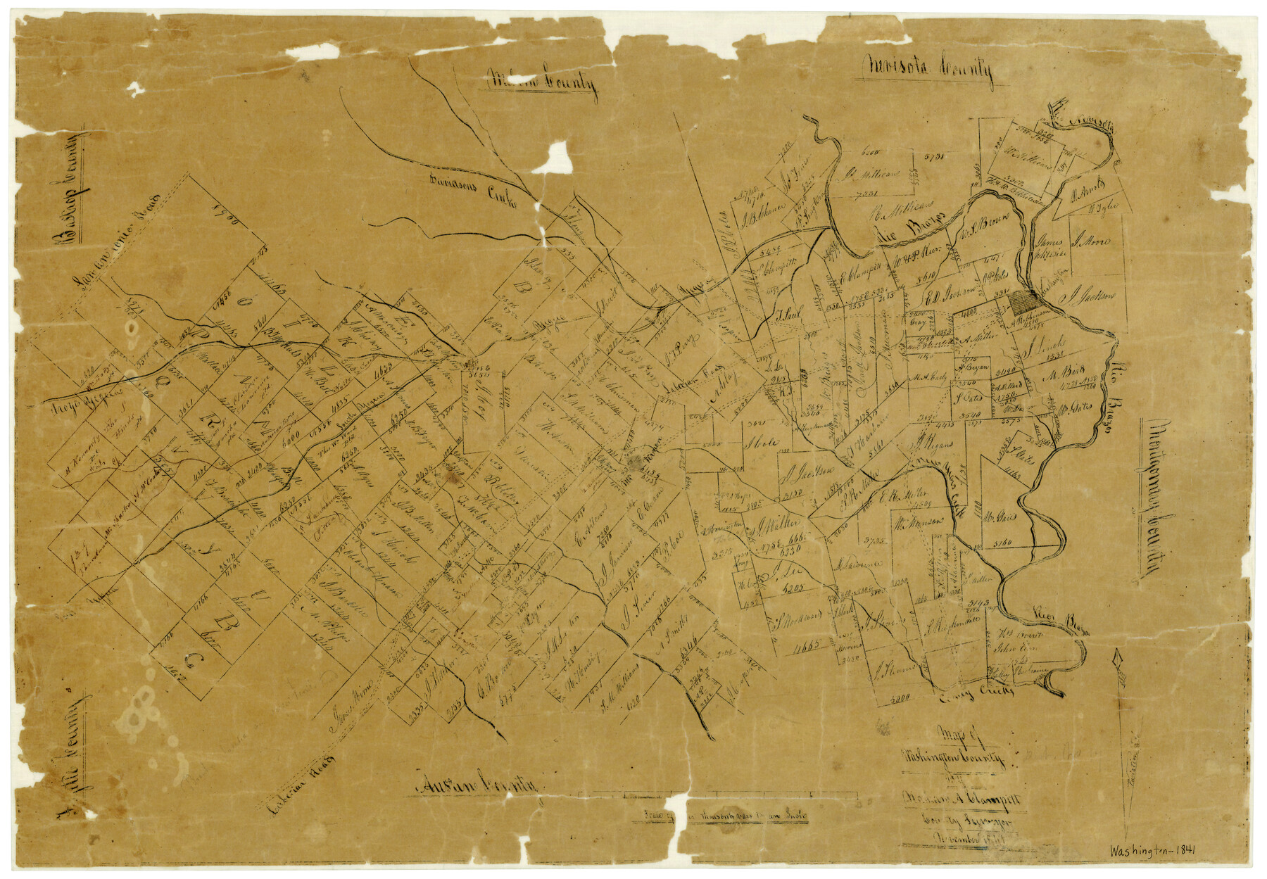
Map of Washington County
-
Map/Doc
4126
-
Collection
General Map Collection
-
Object Dates
11/1841 (Creation Date)
-
People and Organizations
Washington County (Publisher)
Nathan A. Clampitt (Compiler)
Nathan A. Clampitt (Surveyor/Engineer)
Nathan A. Clampitt (Draftsman)
-
Counties
Washington
-
Subjects
County
-
Height x Width
18.9 x 27.1 inches
48.0 x 68.8 cm
-
Medium
paper, manuscript
-
Features
San Antonio Road
Davidson's Creek
Rio Navisota [sic]
Rio Brazos
Aroyo [sic] Yegua
Nails Creek
South Yegua Arroyo
Laberian Road
Washington
New Years Creek
Mount Vernon
Yegua Creek
Caney Creek
Part of: General Map Collection

Rand, McNally and Co.'s Texas and Indian Territory

Print $20.00
- Digital $50.00
Rand, McNally and Co.'s Texas and Indian Territory
1883
Size 24.3 x 18.6 inches
Map/Doc 4331
Webb County Sketch File 4a

Print $8.00
- Digital $50.00
Webb County Sketch File 4a
1877
Size 11.6 x 4.0 inches
Map/Doc 39718
Jim Hogg County Rolled Sketch 13

Print $65.00
- Digital $50.00
Jim Hogg County Rolled Sketch 13
1913
Size 21.9 x 28.1 inches
Map/Doc 6444

Harris County Rolled Sketch W

Print $40.00
- Digital $50.00
Harris County Rolled Sketch W
1936
Size 43.0 x 64.4 inches
Map/Doc 9124
Webb County Rolled Sketch 72

Print $20.00
- Digital $50.00
Webb County Rolled Sketch 72
1976
Size 25.5 x 17.5 inches
Map/Doc 8220
Galveston County Working Sketch 13

Print $20.00
- Digital $50.00
Galveston County Working Sketch 13
1975
Size 23.1 x 16.7 inches
Map/Doc 69350
San Patricio County Sketch File 20

Print $14.00
San Patricio County Sketch File 20
1868
Size 9.2 x 8.5 inches
Map/Doc 36069
Haskell County

Print $20.00
- Digital $50.00
Haskell County
1933
Size 41.7 x 36.2 inches
Map/Doc 77307
Somervell County Rolled Sketch D

Print $20.00
- Digital $50.00
Somervell County Rolled Sketch D
1939
Size 17.3 x 21.0 inches
Map/Doc 7794
Nacogdoches Co.

Print $20.00
- Digital $50.00
Nacogdoches Co.
1905
Size 47.6 x 40.5 inches
Map/Doc 66948
You may also like
Kendall County Sketch File 4

Print $4.00
- Digital $50.00
Kendall County Sketch File 4
Size 7.8 x 8.6 inches
Map/Doc 28684
Schleicher County Sketch File 20

Print $20.00
- Digital $50.00
Schleicher County Sketch File 20
1936
Size 16.8 x 17.4 inches
Map/Doc 12301
Tarrant's Key and Guide to Dallas

Print $3.00
- Digital $50.00
Tarrant's Key and Guide to Dallas
1922
Size 7.9 x 10.3 inches
Map/Doc 89275
South Part of Webb County

Print $40.00
- Digital $50.00
South Part of Webb County
1984
Size 43.5 x 63.9 inches
Map/Doc 73320

Kerr County Working Sketch 23

Print $20.00
- Digital $50.00
Kerr County Working Sketch 23
1966
Size 33.4 x 41.0 inches
Map/Doc 70054

Uvalde County Working Sketch 63

Print $20.00
- Digital $50.00
Uvalde County Working Sketch 63
1995
Size 26.8 x 42.0 inches
Map/Doc 72133
Maps of Gulf Intracoastal Waterway, Texas - Sabine River to the Rio Grande and connecting waterways including ship channels

Print $20.00
- Digital $50.00
Maps of Gulf Intracoastal Waterway, Texas - Sabine River to the Rio Grande and connecting waterways including ship channels
1966
Size 14.2 x 20.7 inches
Map/Doc 61997
Crockett County Working Sketch 63

Print $20.00
- Digital $50.00
Crockett County Working Sketch 63
1957
Size 21.3 x 36.1 inches
Map/Doc 68396
Hardin County Working Sketch 16

Print $20.00
- Digital $50.00
Hardin County Working Sketch 16
1940
Size 18.1 x 23.2 inches
Map/Doc 63414
Coast Chart No. 211 - Padre I. and Laguna Madre Lat. 27° 12' to Lat. 26° 33' Texas

Print $20.00
- Digital $50.00
Coast Chart No. 211 - Padre I. and Laguna Madre Lat. 27° 12' to Lat. 26° 33' Texas
1890
Size 27.2 x 18.2 inches
Map/Doc 72821