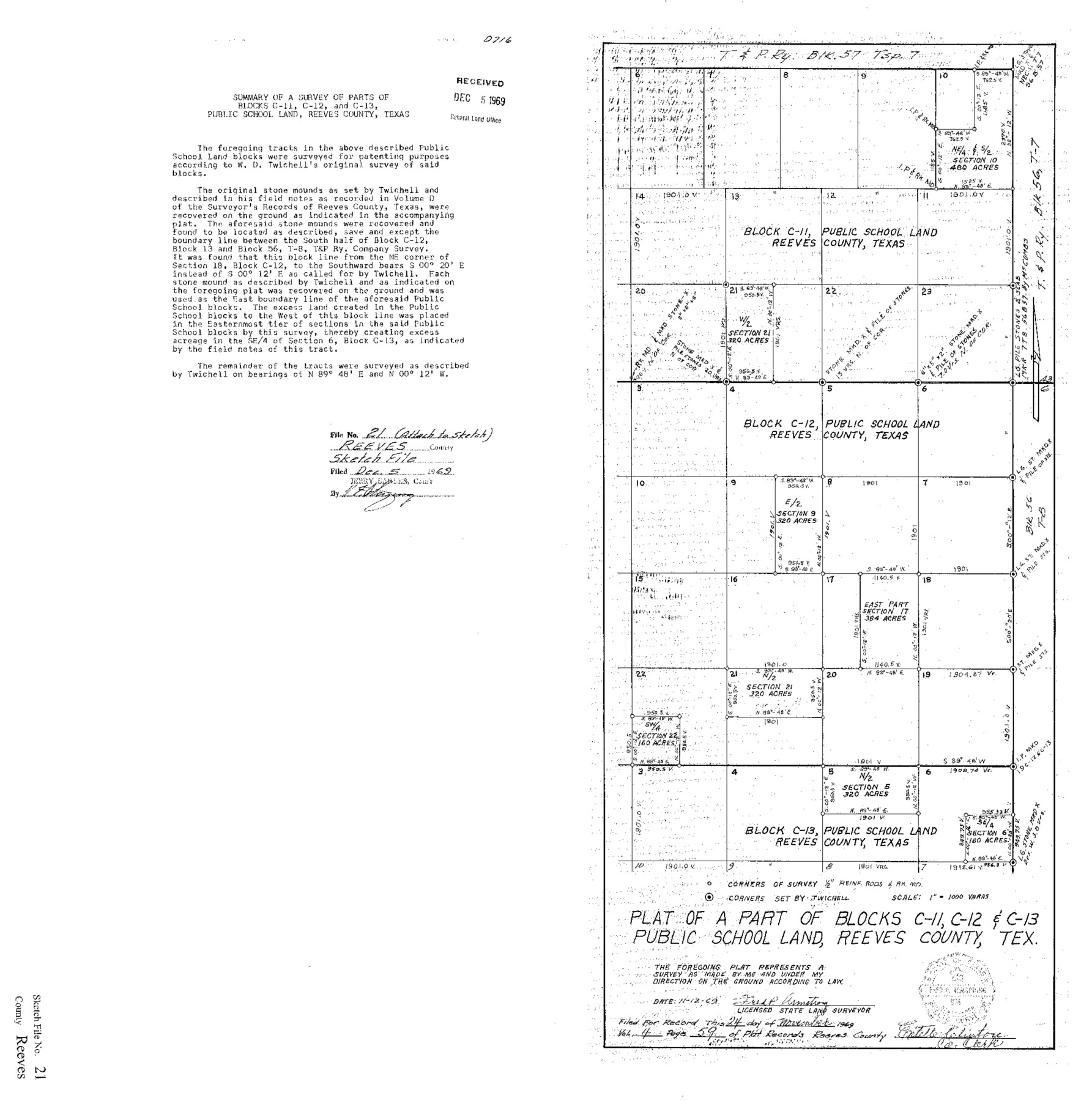
Reeves County Sketch File 21
Plat of a Part of Blocks C-11, C-12 & C-13, Public School Land, Reeves County, Texas
-
Map/Doc
12246
-
Collection
General Map Collection
-
Object Dates
1969/11/24 (File Date)
1969/11/12 (Survey Date)
-
People and Organizations
Fred P. Armstrong (Surveyor/Engineer)
W.D. Twichell (Surveyor/Engineer)
-
Counties
Reeves
-
Subjects
Surveying Sketch File
-
Height x Width
21.9 x 21.7 inches
55.6 x 55.1 cm
-
Medium
paper, print
Part of: General Map Collection
Motley County Sketch File E1 (S)

Print $8.00
- Digital $50.00
Motley County Sketch File E1 (S)
Size 14.3 x 8.7 inches
Map/Doc 32175
Crosby County Sketch File 18

Print $26.00
- Digital $50.00
Crosby County Sketch File 18
1905
Size 14.2 x 8.5 inches
Map/Doc 20071
[Meanders of a navigable river, perhaps Cow Bayou]
![66, [Meanders of a navigable river, perhaps Cow Bayou], General Map Collection](https://historictexasmaps.com/wmedia_w700/maps/66.tif.jpg)
Print $20.00
- Digital $50.00
[Meanders of a navigable river, perhaps Cow Bayou]
1842
Size 14.0 x 16.6 inches
Map/Doc 66
Map of Tyler County

Print $20.00
- Digital $50.00
Map of Tyler County
1863
Size 21.0 x 22.3 inches
Map/Doc 4099
Bell County Working Sketch 19

Print $40.00
- Digital $50.00
Bell County Working Sketch 19
1994
Size 48.3 x 38.4 inches
Map/Doc 67359
[Map of Lynn County]
![4586, [Map of Lynn County], General Map Collection](https://historictexasmaps.com/wmedia_w700/maps/4586-1.tif.jpg)
Print $20.00
- Digital $50.00
[Map of Lynn County]
Size 22.4 x 17.8 inches
Map/Doc 4586
Val Verde County Working Sketch 121

Print $40.00
- Digital $50.00
Val Verde County Working Sketch 121
2005
Size 34.0 x 54.2 inches
Map/Doc 83590
Flight Mission No. DCL-7C, Frame 6, Kenedy County

Print $20.00
- Digital $50.00
Flight Mission No. DCL-7C, Frame 6, Kenedy County
1943
Size 15.5 x 15.4 inches
Map/Doc 85998
Travis County Rolled Sketch 30

Print $20.00
- Digital $50.00
Travis County Rolled Sketch 30
1943
Size 26.5 x 25.6 inches
Map/Doc 8032
Galveston County NRC Article 33.136 Sketch 95

Print $40.00
Galveston County NRC Article 33.136 Sketch 95
2024
Map/Doc 97368
Brewster County Working Sketch 26

Print $20.00
- Digital $50.00
Brewster County Working Sketch 26
1940
Size 20.7 x 32.1 inches
Map/Doc 67560
Map of Jackson County

Print $20.00
- Digital $50.00
Map of Jackson County
1840
Size 34.9 x 25.3 inches
Map/Doc 3707
You may also like
Texas Official Highway Travel Map

Digital $50.00
Texas Official Highway Travel Map
Size 27.3 x 36.3 inches
Map/Doc 94306
Railroad and County Map of Texas

Print $20.00
- Digital $50.00
Railroad and County Map of Texas
1906
Size 46.0 x 47.6 inches
Map/Doc 10748
The Fisher-Miller Colony. September 1, 1843

Print $20.00
The Fisher-Miller Colony. September 1, 1843
2020
Size 13.8 x 21.7 inches
Map/Doc 96359
Zapata County Sketch File 8

Print $40.00
- Digital $50.00
Zapata County Sketch File 8
1917
Size 59.5 x 26.5 inches
Map/Doc 10438
Jasper County Sketch File 35

Print $6.00
- Digital $50.00
Jasper County Sketch File 35
Size 17.0 x 10.7 inches
Map/Doc 27870
Winkler County Sketch File 1 and 2

Print $64.00
- Digital $50.00
Winkler County Sketch File 1 and 2
1900
Size 8.4 x 9.2 inches
Map/Doc 40431
Trinity County Sketch File 18 1/2

Print $4.00
- Digital $50.00
Trinity County Sketch File 18 1/2
1876
Size 9.0 x 11.2 inches
Map/Doc 38548
Brazoria County Working Sketch 29

Print $20.00
- Digital $50.00
Brazoria County Working Sketch 29
1971
Size 30.6 x 28.3 inches
Map/Doc 67514
Flight Mission No. DQO-11K, Frame 22, Galveston County

Print $20.00
- Digital $50.00
Flight Mission No. DQO-11K, Frame 22, Galveston County
1952
Size 18.8 x 22.5 inches
Map/Doc 85219
Jackson County Sketch File 27

Print $20.00
- Digital $50.00
Jackson County Sketch File 27
1938
Size 25.6 x 24.8 inches
Map/Doc 11847
Baylor County Sketch File 14

Print $4.00
- Digital $50.00
Baylor County Sketch File 14
1879
Size 13.0 x 8.2 inches
Map/Doc 14181
Wheeler County Working Sketch 11

Print $40.00
- Digital $50.00
Wheeler County Working Sketch 11
1973
Size 77.4 x 44.0 inches
Map/Doc 72500