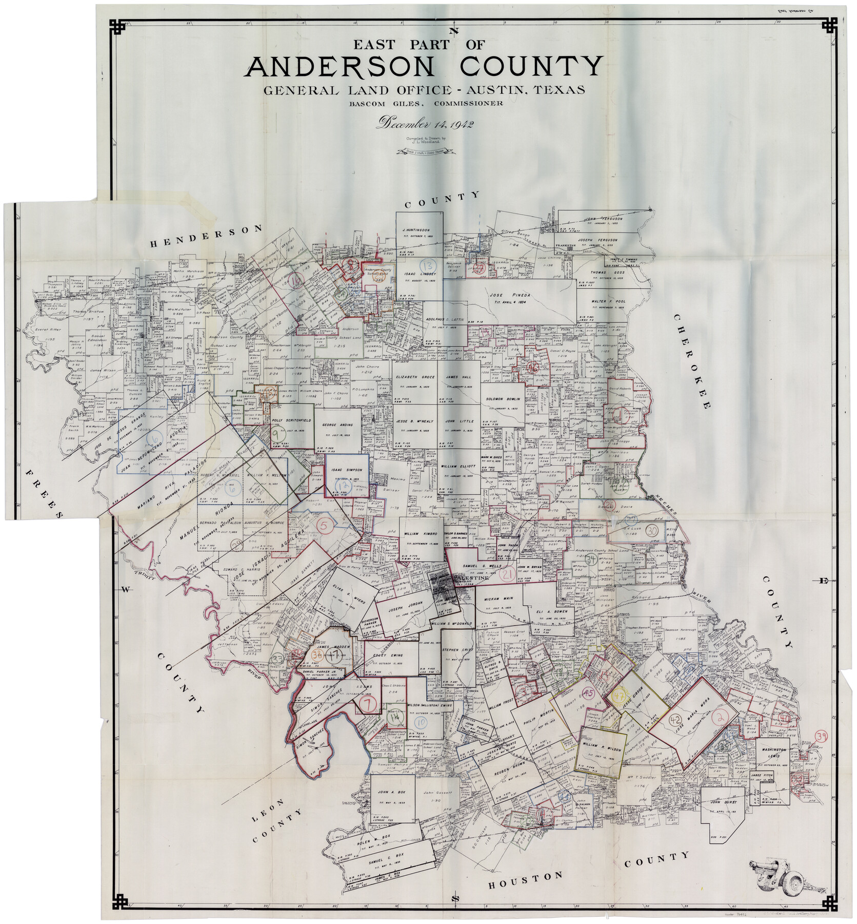
Anderson County Working Sketch Graphic Index
-
Map/Doc
76452
-
Collection
General Map Collection
-
Object Dates
12/14/1942 (Creation Date)
-
Counties
Anderson
-
Subjects
County Surveying Working Sketch
-
Height x Width
52.0 x 48.3 inches
132.1 x 122.7 cm
-
Scale
1" = 1000 varas
Part of: General Map Collection
Flight Mission No. BQR-4K, Frame 68, Brazoria County

Print $20.00
- Digital $50.00
Flight Mission No. BQR-4K, Frame 68, Brazoria County
1952
Size 18.7 x 22.4 inches
Map/Doc 84001

Flight Mission No. BQY-15M, Frame 4, Harris County

Print $20.00
- Digital $50.00
Flight Mission No. BQY-15M, Frame 4, Harris County
1953
Size 18.6 x 22.4 inches
Map/Doc 85302
Bee County Working Sketch Graphic Index

Print $20.00
- Digital $50.00
Bee County Working Sketch Graphic Index
1950
Size 41.6 x 45.4 inches
Map/Doc 76464
Callahan County Working Sketch 4

Print $20.00
- Digital $50.00
Callahan County Working Sketch 4
1953
Size 17.1 x 27.0 inches
Map/Doc 67886
Map of Jones County West of the Clearfork of the Brazos River Young - East of it Milam - Land District

Print $20.00
- Digital $50.00
Map of Jones County West of the Clearfork of the Brazos River Young - East of it Milam - Land District
1859
Size 22.0 x 26.5 inches
Map/Doc 3741
Kendall County Rolled Sketch 5

Print $20.00
- Digital $50.00
Kendall County Rolled Sketch 5
Size 23.4 x 19.3 inches
Map/Doc 6458
Walker County

Print $20.00
- Digital $50.00
Walker County
1944
Size 45.7 x 38.4 inches
Map/Doc 73314
Tarrant County Sketch File 10

Print $8.00
- Digital $50.00
Tarrant County Sketch File 10
1859
Size 12.9 x 8.4 inches
Map/Doc 37694
San Augustine County Working Sketch 23

Print $20.00
- Digital $50.00
San Augustine County Working Sketch 23
1974
Size 23.6 x 36.4 inches
Map/Doc 63711
Hardeman County Working Sketch 5

Print $20.00
- Digital $50.00
Hardeman County Working Sketch 5
Size 23.0 x 35.7 inches
Map/Doc 63386
Flight Mission No. DQN-1K, Frame 129, Calhoun County

Print $20.00
- Digital $50.00
Flight Mission No. DQN-1K, Frame 129, Calhoun County
1953
Size 18.5 x 22.2 inches
Map/Doc 84192
You may also like
[Sketch for Mineral Application 33721 - 33725 Incl. - Padre and Mustang Island]
![2869, [Sketch for Mineral Application 33721 - 33725 Incl. - Padre and Mustang Island], General Map Collection](https://historictexasmaps.com/wmedia_w700/maps/2869.tif.jpg)
Print $20.00
- Digital $50.00
[Sketch for Mineral Application 33721 - 33725 Incl. - Padre and Mustang Island]
1942
Size 22.2 x 22.3 inches
Map/Doc 2869
La Salle County Sketch File 16

Print $5.00
- Digital $50.00
La Salle County Sketch File 16
1883
Size 9.3 x 9.7 inches
Map/Doc 29487
Hays County Sketch File 28

Print $20.00
- Digital $50.00
Hays County Sketch File 28
1912
Size 26.0 x 20.0 inches
Map/Doc 11750
Comal County Sketch File 7

Print $4.00
- Digital $50.00
Comal County Sketch File 7
Size 13.5 x 8.3 inches
Map/Doc 19011
Colorado County Sketch File 16a

Print $4.00
- Digital $50.00
Colorado County Sketch File 16a
Size 12.7 x 8.1 inches
Map/Doc 18947
Sketch in Crockett County [UT Blk. 31, 32, 46, 51, Blks. UV, ST, QR, MN]
![89677, Sketch in Crockett County [UT Blk. 31, 32, 46, 51, Blks. UV, ST, QR, MN], Twichell Survey Records](https://historictexasmaps.com/wmedia_w700/maps/89677-1.tif.jpg)
Print $40.00
- Digital $50.00
Sketch in Crockett County [UT Blk. 31, 32, 46, 51, Blks. UV, ST, QR, MN]
1913
Size 33.7 x 48.0 inches
Map/Doc 89677
Mitchell County

Print $20.00
- Digital $50.00
Mitchell County
1889
Size 42.3 x 35.7 inches
Map/Doc 10792
Hudspeth County Sketch File 8

Print $20.00
- Digital $50.00
Hudspeth County Sketch File 8
1886
Size 40.7 x 43.3 inches
Map/Doc 10493
Dallas County Sketch File 19 1/2

Print $4.00
- Digital $50.00
Dallas County Sketch File 19 1/2
Size 9.9 x 8.2 inches
Map/Doc 20439
Fractional Township No. 8 South Range No. 8 East of the Indian Meridian, Indian Territory

Print $20.00
- Digital $50.00
Fractional Township No. 8 South Range No. 8 East of the Indian Meridian, Indian Territory
1898
Size 19.2 x 24.2 inches
Map/Doc 75214
Collingsworth County Sketch File 3

Print $20.00
- Digital $50.00
Collingsworth County Sketch File 3
1888
Size 32.5 x 27.7 inches
Map/Doc 11130
Limestone County Sketch File 10a

Print $22.00
- Digital $50.00
Limestone County Sketch File 10a
Size 12.5 x 15.8 inches
Map/Doc 30173