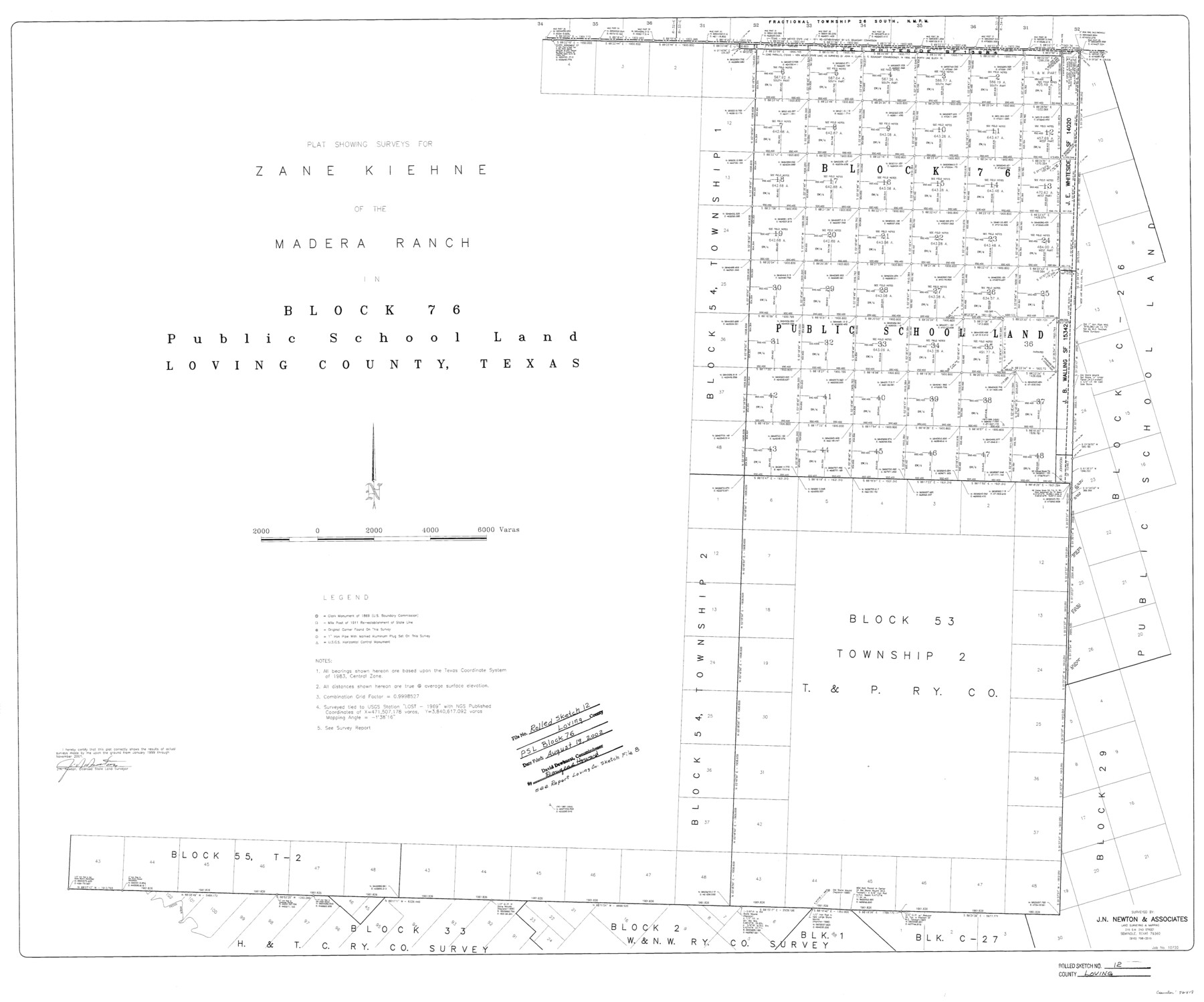
Loving County Rolled Sketch 12
Plat showing surveys for Zane Kiehne of the Madera Ranch in Block 76, Public School Land, Loving County, Texas
-
Map/Doc
76418
-
Collection
General Map Collection
-
Object Dates
2001 (Survey Date)
2002/8/19 (File Date)
-
People and Organizations
J.N. Newton (Surveyor/Engineer)
-
Counties
Loving
-
Subjects
Surveying Rolled Sketch
-
Height x Width
35.5 x 42.6 inches
90.2 x 108.2 cm
-
Medium
mylar, print
-
Comments
See Loving County Sketch File 8 (76377) for report.
Related maps
Loving County Sketch File 8

Print $44.00
- Digital $50.00
Loving County Sketch File 8
2002
Size 11.2 x 8.7 inches
Map/Doc 76377
Part of: General Map Collection
Wilson County

Print $40.00
- Digital $50.00
Wilson County
1921
Size 39.9 x 48.8 inches
Map/Doc 95677
Palo Pinto County Working Sketch 15

Print $20.00
- Digital $50.00
Palo Pinto County Working Sketch 15
1971
Size 26.4 x 30.8 inches
Map/Doc 71398
Childress County Rolled Sketch 9

Print $20.00
- Digital $50.00
Childress County Rolled Sketch 9
Size 19.3 x 22.9 inches
Map/Doc 5446
Bosque County Sketch File 9

Print $6.00
- Digital $50.00
Bosque County Sketch File 9
1859
Size 4.3 x 4.7 inches
Map/Doc 14754
Leon County Sketch File 38

Print $10.00
- Digital $50.00
Leon County Sketch File 38
1999
Size 11.0 x 8.5 inches
Map/Doc 29878
Duval County Sketch File 8c

Print $4.00
- Digital $50.00
Duval County Sketch File 8c
1875
Size 10.9 x 8.6 inches
Map/Doc 21300
Loving County State of Texas

Print $20.00
- Digital $50.00
Loving County State of Texas
1889
Size 20.6 x 24.3 inches
Map/Doc 4582
Galveston County Rolled Sketch 27

Print $20.00
- Digital $50.00
Galveston County Rolled Sketch 27
1978
Size 29.6 x 33.3 inches
Map/Doc 10301
Briscoe County Boundary File 5

Print $4.00
Briscoe County Boundary File 5
1894
Size 10.6 x 8.1 inches
Map/Doc 50802
McMullen County Working Sketch 32

Print $20.00
- Digital $50.00
McMullen County Working Sketch 32
1958
Size 28.2 x 32.5 inches
Map/Doc 70733
Lee County Sketch File 1

Print $4.00
- Digital $50.00
Lee County Sketch File 1
1856
Size 13.1 x 8.2 inches
Map/Doc 29678
Zavala County Sketch File 43

Print $20.00
- Digital $50.00
Zavala County Sketch File 43
1915
Size 26.8 x 32.4 inches
Map/Doc 12733
You may also like
Marion County Working Sketch 34

Print $20.00
- Digital $50.00
Marion County Working Sketch 34
1983
Size 45.2 x 23.2 inches
Map/Doc 70810
Crockett County Working Sketch 54

Print $20.00
- Digital $50.00
Crockett County Working Sketch 54
1951
Size 34.5 x 30.7 inches
Map/Doc 68387

Map of Fort Worth & Denver City Railway

Print $40.00
- Digital $50.00
Map of Fort Worth & Denver City Railway
1880
Size 25.3 x 50.3 inches
Map/Doc 64416
Cameron County NRC Article 33.136 Location Key Sheet

Print $20.00
- Digital $50.00
Cameron County NRC Article 33.136 Location Key Sheet
1983
Size 27.0 x 23.0 inches
Map/Doc 89294
[Blocks 71 and C-8]
![91778, [Blocks 71 and C-8], Twichell Survey Records](https://historictexasmaps.com/wmedia_w700/maps/91778-1.tif.jpg)
Print $20.00
- Digital $50.00
[Blocks 71 and C-8]
Size 29.7 x 21.1 inches
Map/Doc 91778
Edwards County Working Sketch 19

Print $20.00
- Digital $50.00
Edwards County Working Sketch 19
1934
Size 24.1 x 24.6 inches
Map/Doc 68895
Wharton County Rolled Sketch 8

Print $20.00
- Digital $50.00
Wharton County Rolled Sketch 8
Size 24.4 x 39.2 inches
Map/Doc 8232
Leon County Working Sketch 21

Print $20.00
- Digital $50.00
Leon County Working Sketch 21
1964
Size 20.9 x 22.9 inches
Map/Doc 70420
USGS Topographic, De Kalb NW, Texas Quadrangle

Print $20.00
- Digital $50.00
USGS Topographic, De Kalb NW, Texas Quadrangle
1950
Size 26.8 x 21.6 inches
Map/Doc 77604
Flight Mission No. CRC-4R, Frame 71, Chambers County

Print $20.00
- Digital $50.00
Flight Mission No. CRC-4R, Frame 71, Chambers County
1956
Size 18.7 x 22.5 inches
Map/Doc 84875
General Highway Map, Calhoun County, Texas

Print $20.00
General Highway Map, Calhoun County, Texas
1961
Size 18.3 x 24.4 inches
Map/Doc 79395