Briscoe County Boundary File 5
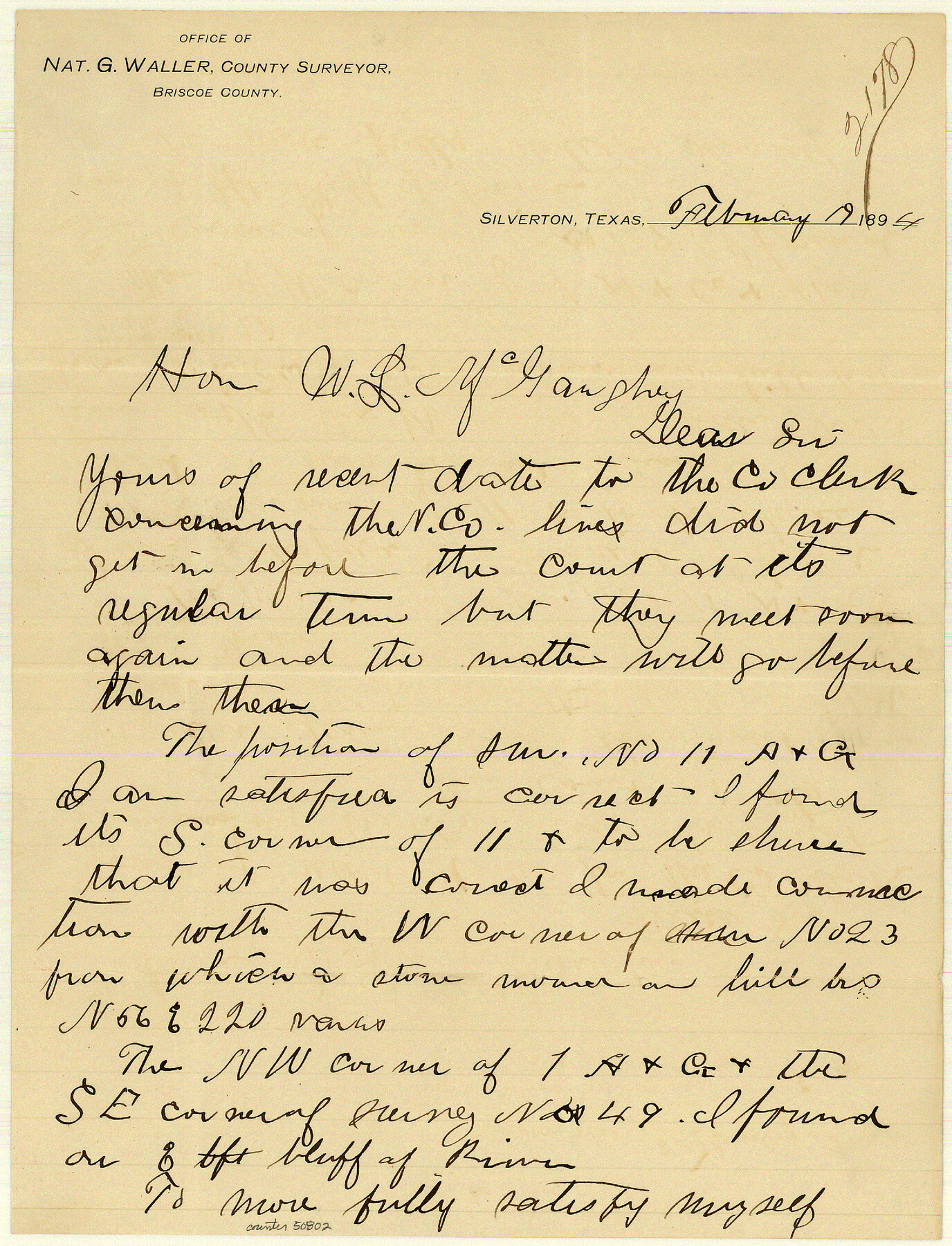
[Letter to the GLO regarding the court order for the Briscoe-Donley-Armstrong Co. Line]
-
Map/Doc
50802
-
Collection
General Map Collection
-
Object Dates
2/19/1894 (Creation Date)
-
People and Organizations
Nat G. Waller (Surveyor/Engineer)
-
Counties
Briscoe
-
Subjects
County Boundaries
-
Height x Width
10.6 x 8.1 inches
26.9 x 20.6 cm
Part of: General Map Collection
Victoria County Working Sketch 3

Print $20.00
- Digital $50.00
Victoria County Working Sketch 3
1939
Size 14.0 x 18.3 inches
Map/Doc 72273
Cochran County Boundary File 1a

Print $10.00
- Digital $50.00
Cochran County Boundary File 1a
Size 11.2 x 8.8 inches
Map/Doc 51461
Brazoria County Sketch File 18

Print $18.00
- Digital $50.00
Brazoria County Sketch File 18
Size 14.5 x 8.9 inches
Map/Doc 14989
Lamar County Working Sketch 2

Print $20.00
- Digital $50.00
Lamar County Working Sketch 2
Size 27.9 x 25.6 inches
Map/Doc 70263
Fannin County

Print $20.00
- Digital $50.00
Fannin County
1946
Size 42.3 x 37.4 inches
Map/Doc 73145
Starr County Rolled Sketch 42

Print $20.00
- Digital $50.00
Starr County Rolled Sketch 42
1972
Size 26.0 x 18.4 inches
Map/Doc 7835
Kimble County Working Sketch 69

Print $20.00
- Digital $50.00
Kimble County Working Sketch 69
1965
Size 42.4 x 30.5 inches
Map/Doc 70137

Map of Ramsey State Farm, Brazoria County, Texas

Print $20.00
- Digital $50.00
Map of Ramsey State Farm, Brazoria County, Texas
Size 28.7 x 36.5 inches
Map/Doc 62998
Tabular exhibit of the land occupied by the roadbed of the Galveston, Harrisburg and San Antonio Railway in El Paso County, Texas

Print $20.00
- Digital $50.00
Tabular exhibit of the land occupied by the roadbed of the Galveston, Harrisburg and San Antonio Railway in El Paso County, Texas
Size 12.7 x 8.2 inches
Map/Doc 64499
Maps of Gulf Intracoastal Waterway, Texas - Sabine River to the Rio Grande and connecting waterways including ship channels

Print $20.00
- Digital $50.00
Maps of Gulf Intracoastal Waterway, Texas - Sabine River to the Rio Grande and connecting waterways including ship channels
1966
Size 14.5 x 22.2 inches
Map/Doc 61931
Schleicher County Rolled Sketch 8

Print $20.00
- Digital $50.00
Schleicher County Rolled Sketch 8
Size 27.8 x 29.0 inches
Map/Doc 7750
You may also like
Flight Mission No. DCL-7C, Frame 36, Kenedy County

Print $20.00
- Digital $50.00
Flight Mission No. DCL-7C, Frame 36, Kenedy County
1943
Size 18.5 x 22.4 inches
Map/Doc 86024
Jackson County Working Sketch 3

Print $20.00
- Digital $50.00
Jackson County Working Sketch 3
1941
Size 34.3 x 29.8 inches
Map/Doc 66451
Flight Mission No. BQR-9K, Frame 43, Brazoria County

Print $20.00
- Digital $50.00
Flight Mission No. BQR-9K, Frame 43, Brazoria County
1952
Size 18.6 x 22.3 inches
Map/Doc 84047
Taylor County Rolled Sketch 21

Print $20.00
- Digital $50.00
Taylor County Rolled Sketch 21
Size 31.5 x 40.5 inches
Map/Doc 9985
Denton County Sketch File 18

Print $4.00
- Digital $50.00
Denton County Sketch File 18
1856
Size 7.9 x 7.3 inches
Map/Doc 20731
Ochiltree County Sketch File 2

Print $38.00
- Digital $50.00
Ochiltree County Sketch File 2
1903
Size 11.3 x 8.6 inches
Map/Doc 33168
Laguna Madre, Texas from Triangulation Station Singer to Latitude 26° 20'

Print $40.00
- Digital $50.00
Laguna Madre, Texas from Triangulation Station Singer to Latitude 26° 20'
1880
Size 31.9 x 53.4 inches
Map/Doc 73493
Comal County Working Sketch 12

Print $20.00
- Digital $50.00
Comal County Working Sketch 12
1987
Size 31.1 x 29.6 inches
Map/Doc 68178
Survey 1, Block 1, D.B. Gardner in Dickens County

Print $20.00
- Digital $50.00
Survey 1, Block 1, D.B. Gardner in Dickens County
1914
Size 14.9 x 30.4 inches
Map/Doc 10767
Map of Texas, showing the line of the Texas and New Orleans Rail Road, and its connections in the U.S. and adjacent territories.

Print $20.00
Map of Texas, showing the line of the Texas and New Orleans Rail Road, and its connections in the U.S. and adjacent territories.
1860
Size 22.0 x 31.1 inches
Map/Doc 93612
Schleicher County Rolled Sketch 1

Print $20.00
- Digital $50.00
Schleicher County Rolled Sketch 1
1888
Size 25.3 x 18.4 inches
Map/Doc 7745
Pecos County Sketch File 112

Print $16.00
- Digital $50.00
Pecos County Sketch File 112
1892
Size 11.2 x 8.6 inches
Map/Doc 34061