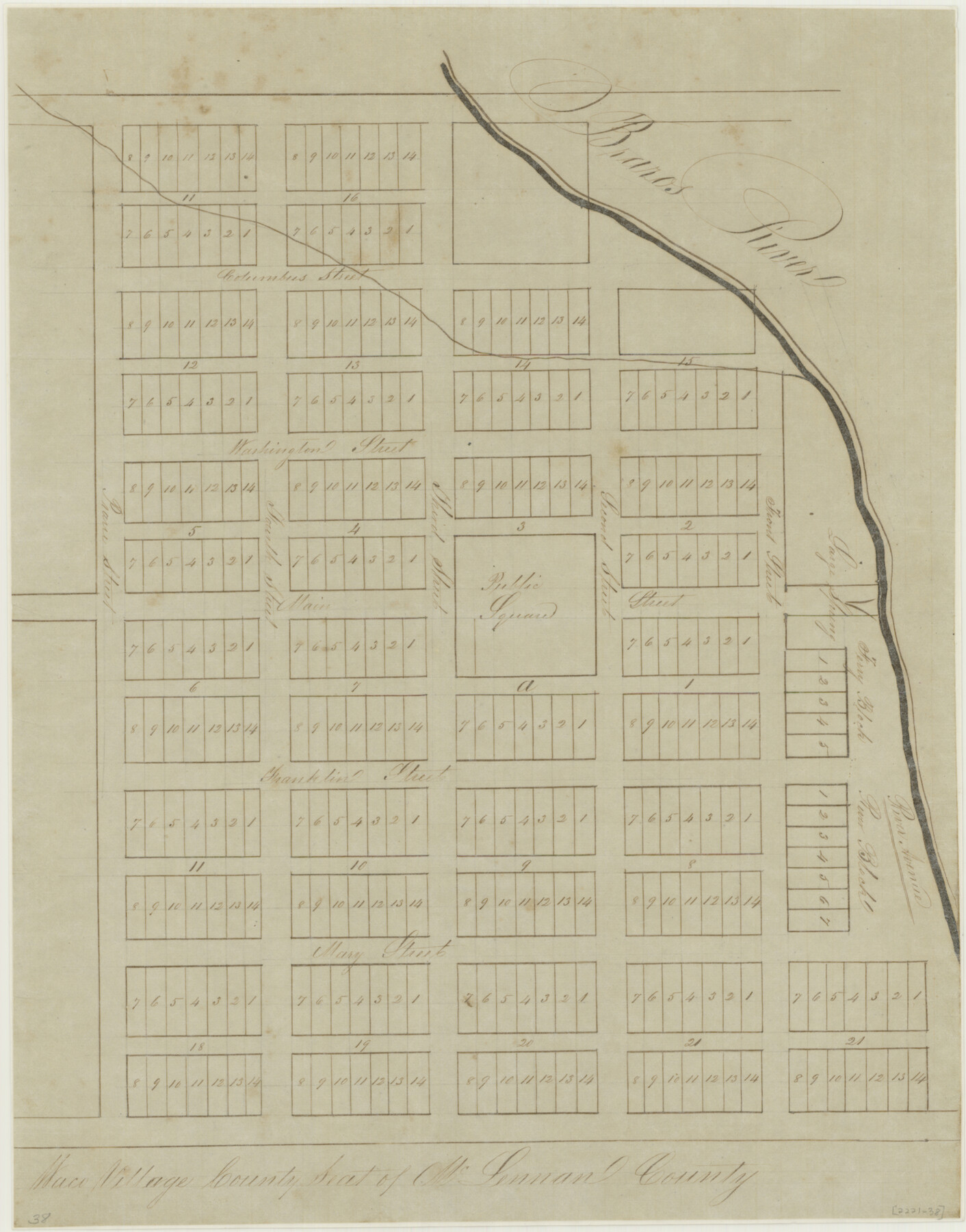
Waco Village, County Seat of McLennan County
-
Map/Doc
76268
-
Collection
Texas State Library and Archives
-
Object Dates
1850 (Creation Date)
-
Counties
McLennan
-
Subjects
City
-
Height x Width
15.8 x 12.4 inches
40.1 x 31.5 cm
-
Comments
Prints available courtesy of the Texas State Library and Archives.
More info can be found here: TSLAC Map 02221-38
Part of: Texas State Library and Archives
General Highway Map. Detail of Cities and Towns in Smith County, Texas. City Map, Tyler, Smith County, Texas

Print $20.00
General Highway Map. Detail of Cities and Towns in Smith County, Texas. City Map, Tyler, Smith County, Texas
1961
Size 18.1 x 24.9 inches
Map/Doc 79656
General Highway Map, Stephens County, Texas

Print $20.00
General Highway Map, Stephens County, Texas
1961
Size 25.0 x 18.2 inches
Map/Doc 79660
General Highway Map, Jim Wells County, Texas

Print $20.00
General Highway Map, Jim Wells County, Texas
1961
Size 18.2 x 24.6 inches
Map/Doc 79543
General Highway Map, Lynn County, Texas

Print $20.00
General Highway Map, Lynn County, Texas
1961
Size 18.1 x 24.6 inches
Map/Doc 79580
General Highway Map. Detail of Cities and Towns in Fort Bend County, Texas

Print $20.00
General Highway Map. Detail of Cities and Towns in Fort Bend County, Texas
1961
Size 18.1 x 24.5 inches
Map/Doc 79470
General Highway Map, Throckmorton County, Texas

Print $20.00
General Highway Map, Throckmorton County, Texas
1940
Size 24.9 x 18.2 inches
Map/Doc 79258
Pocket Map of the State of Texas reduced from their original map of the State and drawn by Chas. W. Pressler and A. B. Langermann

Print $20.00
Pocket Map of the State of Texas reduced from their original map of the State and drawn by Chas. W. Pressler and A. B. Langermann
1879
Size 24.4 x 26.3 inches
Map/Doc 76208

Official Railroad and County Map of Texas

Print $40.00
Official Railroad and County Map of Texas
1914
Size 45.8 x 48.6 inches
Map/Doc 76233
A Map of Louisiana and Mexico

Print $20.00
A Map of Louisiana and Mexico
1820
Size 43.0 x 32.6 inches
Map/Doc 76218
General Highway Map, Clay County, Texas

Print $20.00
General Highway Map, Clay County, Texas
1961
Size 24.8 x 18.2 inches
Map/Doc 79409
General Highway Map. Detail of Cities and Towns in Cherokee County, Texas [Jacksonville, Rusk, Alto, Wells, and vicinities of these cities]
![79407, General Highway Map. Detail of Cities and Towns in Cherokee County, Texas [Jacksonville, Rusk, Alto, Wells, and vicinities of these cities], Texas State Library and Archives](https://historictexasmaps.com/wmedia_w700/maps/79407.tif.jpg)
Print $20.00
General Highway Map. Detail of Cities and Towns in Cherokee County, Texas [Jacksonville, Rusk, Alto, Wells, and vicinities of these cities]
1961
Size 18.2 x 24.9 inches
Map/Doc 79407
You may also like
Coke County Sketch File 33

Print $20.00
- Digital $50.00
Coke County Sketch File 33
Size 22.0 x 26.6 inches
Map/Doc 11115
Tyler County Sketch File 7a

Print $7.00
- Digital $50.00
Tyler County Sketch File 7a
1874
Size 10.3 x 8.1 inches
Map/Doc 38639
Clay County Sketch File 8

Print $4.00
- Digital $50.00
Clay County Sketch File 8
1860
Size 5.5 x 8.3 inches
Map/Doc 18398
Map of Concho County

Print $20.00
- Digital $50.00
Map of Concho County
1879
Size 25.1 x 18.4 inches
Map/Doc 3436
[School Leagues in Bailey and Lamb County]
![90987, [School Leagues in Bailey and Lamb County], Twichell Survey Records](https://historictexasmaps.com/wmedia_w700/maps/90987-2.tif.jpg)
Print $20.00
- Digital $50.00
[School Leagues in Bailey and Lamb County]
Size 30.5 x 25.2 inches
Map/Doc 90987
Section G Tech Memorial Park, Inc., Catholic Section

Print $20.00
- Digital $50.00
Section G Tech Memorial Park, Inc., Catholic Section
Size 18.0 x 30.8 inches
Map/Doc 92354
Martin County

Print $20.00
- Digital $50.00
Martin County
1933
Size 38.9 x 34.0 inches
Map/Doc 77366
Llano County Working Sketch 12

Print $20.00
- Digital $50.00
Llano County Working Sketch 12
Size 18.8 x 12.5 inches
Map/Doc 70630
Montgomery County Rolled Sketch 26A

Print $20.00
- Digital $50.00
Montgomery County Rolled Sketch 26A
Size 26.9 x 36.8 inches
Map/Doc 6808
Nova et Acurata Totius Americae Tabula

Print $40.00
Nova et Acurata Totius Americae Tabula
1608
Size 40.8 x 56.5 inches
Map/Doc 97019
Harrison County Sketch File 12

Print $20.00
- Digital $50.00
Harrison County Sketch File 12
Size 21.5 x 24.1 inches
Map/Doc 11687
Brewster County Rolled Sketch 49A

Print $20.00
- Digital $50.00
Brewster County Rolled Sketch 49A
1930
Size 23.5 x 29.6 inches
Map/Doc 5224