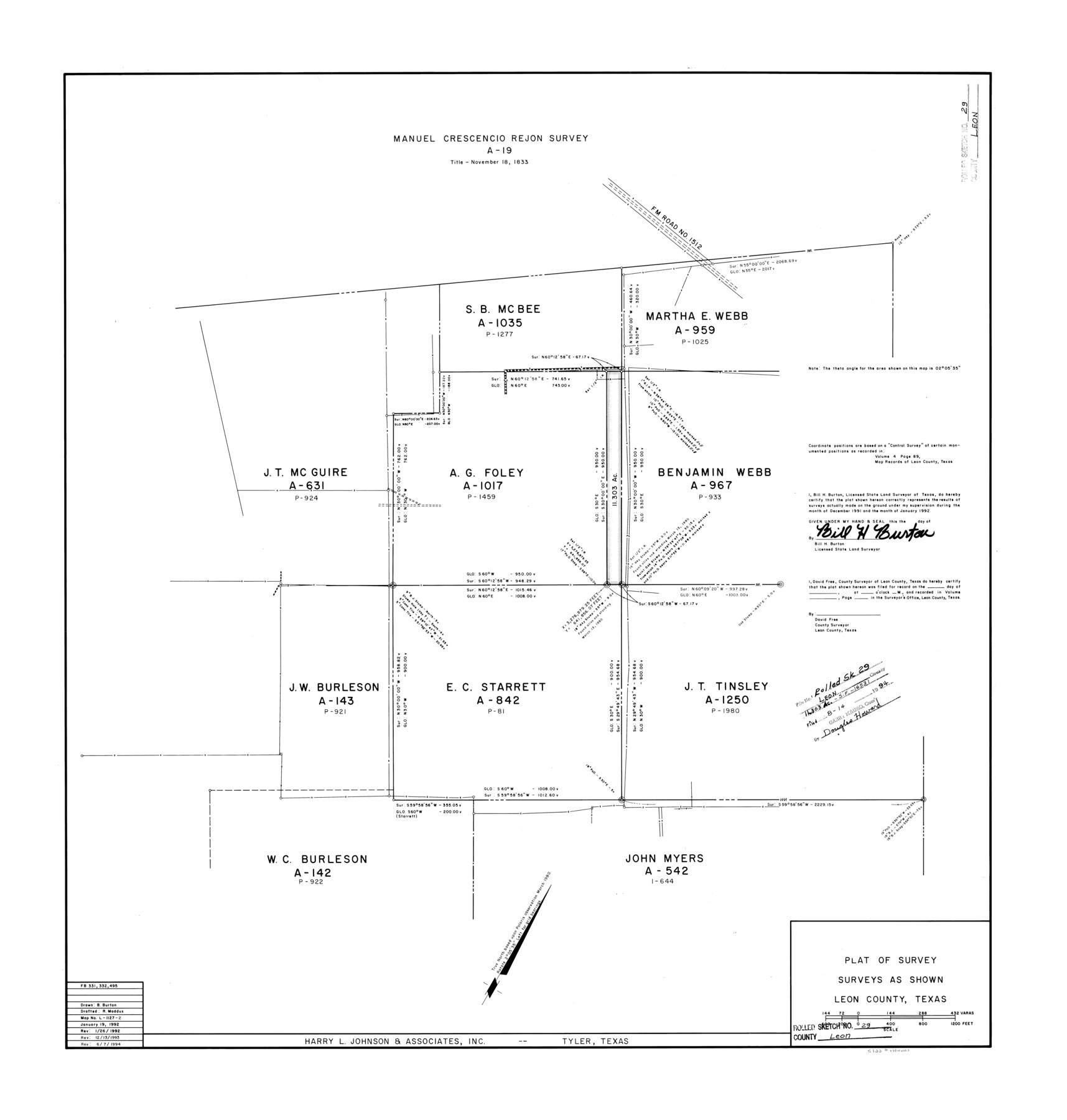
Leon County Rolled Sketch 29
[Plat of A.G. Foley and E.C. Starrett surveys]
-
Map/Doc
6612
-
Collection
General Map Collection
-
Object Dates
1992/1/19 (Creation Date)
1994/8/14 (File Date)
1992/1/26 (Revision Date)
1993/12/13 (Revision Date)
1994/6/7 (Revision Date)
-
People and Organizations
Bill H. Burton (Surveyor/Engineer)
R. Maddux (Draftsman)
-
Counties
Leon
-
Subjects
Surveying Rolled Sketch
-
Height x Width
34.6 x 32.9 inches
87.9 x 83.6 cm
-
Medium
mylar, print
Part of: General Map Collection
Flight Mission No. CGI-4N, Frame 195, Cameron County

Print $20.00
- Digital $50.00
Flight Mission No. CGI-4N, Frame 195, Cameron County
1955
Size 18.5 x 22.3 inches
Map/Doc 84698
Blanco County Rolled Sketch 8

Print $20.00
- Digital $50.00
Blanco County Rolled Sketch 8
Size 19.1 x 27.7 inches
Map/Doc 5145
Flight Mission No. CRC-4R, Frame 160, Chambers County

Print $20.00
- Digital $50.00
Flight Mission No. CRC-4R, Frame 160, Chambers County
1956
Size 18.5 x 22.3 inches
Map/Doc 84919
Zavala County Sketch File 7

Print $6.00
- Digital $50.00
Zavala County Sketch File 7
Size 9.4 x 16.3 inches
Map/Doc 41265
Austin County Sketch File 12

Print $40.00
- Digital $50.00
Austin County Sketch File 12
Size 22.5 x 18.0 inches
Map/Doc 10876
Val Verde County Sketch File 17

Print $12.00
- Digital $50.00
Val Verde County Sketch File 17
Size 12.9 x 8.1 inches
Map/Doc 39219
Terrell County Rolled Sketch 44

Print $20.00
- Digital $50.00
Terrell County Rolled Sketch 44
1952
Size 18.3 x 22.9 inches
Map/Doc 7947
Dickens County Sketch File K

Print $6.00
- Digital $50.00
Dickens County Sketch File K
1907
Size 14.5 x 9.1 inches
Map/Doc 20889
Flight Mission No. CUG-2P, Frame 70, Kleberg County

Print $20.00
- Digital $50.00
Flight Mission No. CUG-2P, Frame 70, Kleberg County
1956
Size 18.7 x 22.4 inches
Map/Doc 86207
Report Upon the Resurvey and Location of the Boundary Line between the States of Texas and New Mexico

Print $1706.00
Report Upon the Resurvey and Location of the Boundary Line between the States of Texas and New Mexico
1911
Map/Doc 81686
Crockett County Working Sketch 101

Print $20.00
- Digital $50.00
Crockett County Working Sketch 101
Size 16.3 x 20.3 inches
Map/Doc 67436
Maps of Gulf Intracoastal Waterway, Texas - Sabine River to the Rio Grande and connecting waterways including ship channels

Print $20.00
- Digital $50.00
Maps of Gulf Intracoastal Waterway, Texas - Sabine River to the Rio Grande and connecting waterways including ship channels
1966
Size 14.5 x 22.2 inches
Map/Doc 61963
You may also like
Cooke County Rolled Sketch 8

Print $20.00
- Digital $50.00
Cooke County Rolled Sketch 8
2003
Size 24.5 x 36.2 inches
Map/Doc 78649
Leon County Sketch File 3

Print $4.00
- Digital $50.00
Leon County Sketch File 3
Size 12.4 x 7.9 inches
Map/Doc 29713
Flight Mission No. DCL-6C, Frame 131, Kenedy County

Print $20.00
- Digital $50.00
Flight Mission No. DCL-6C, Frame 131, Kenedy County
1943
Size 18.7 x 22.3 inches
Map/Doc 85961
Milam County Boundary File 2

Print $30.00
- Digital $50.00
Milam County Boundary File 2
Size 12.7 x 8.2 inches
Map/Doc 57202
Liberty County Sketch File 36a

Print $4.00
- Digital $50.00
Liberty County Sketch File 36a
Size 8.6 x 5.6 inches
Map/Doc 29974
Flight Mission No. BRE-1P, Frame 129, Nueces County

Print $20.00
- Digital $50.00
Flight Mission No. BRE-1P, Frame 129, Nueces County
1956
Size 18.5 x 22.6 inches
Map/Doc 86695
Gillespie County Sketch File 13

Print $4.00
- Digital $50.00
Gillespie County Sketch File 13
1878
Size 8.4 x 10.9 inches
Map/Doc 24153
Shelby County Rolled Sketch 17

Print $20.00
- Digital $50.00
Shelby County Rolled Sketch 17
1975
Size 34.6 x 26.4 inches
Map/Doc 7783
Crockett County Rolled Sketch 94

Print $40.00
- Digital $50.00
Crockett County Rolled Sketch 94
1979
Size 45.0 x 49.7 inches
Map/Doc 8738
Middle Sulphur and South Sulphur Rivers, Horton Sheet

Print $20.00
- Digital $50.00
Middle Sulphur and South Sulphur Rivers, Horton Sheet
1925
Size 25.6 x 22.0 inches
Map/Doc 78330
Colorado County Rolled Sketch 7

Print $20.00
- Digital $50.00
Colorado County Rolled Sketch 7
1997
Size 26.2 x 19.1 inches
Map/Doc 5534
Harris County Boundary File 3

Print $16.00
- Digital $50.00
Harris County Boundary File 3
Size 14.7 x 7.0 inches
Map/Doc 54298