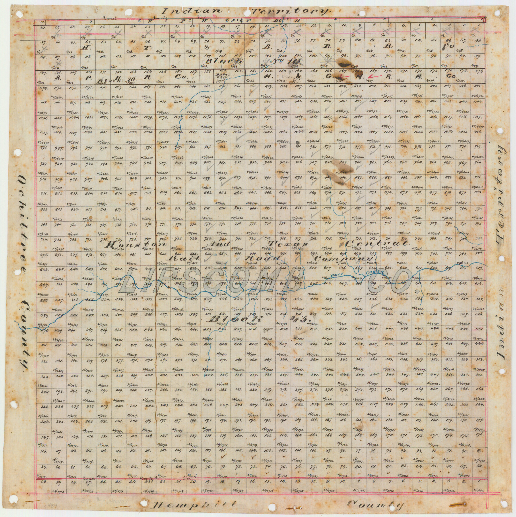
Lipscomb County, Texas
-
Map/Doc
489
-
Collection
Maddox Collection
-
Object Dates
[1880 ca.] (Creation Date)
-
Counties
Lipscomb
-
Subjects
County
-
Height x Width
16.5 x 18.2 inches
41.9 x 46.2 cm
-
Medium
linen, manuscript
-
Comments
Conservation funded in 2011.
-
Features
Indian Territory
Wolf Creek
Part of: Maddox Collection
Survey of a Portion of Lot. No. 1 of Spear League

Print $20.00
- Digital $50.00
Survey of a Portion of Lot. No. 1 of Spear League
1911
Size 12.2 x 24.2 inches
Map/Doc 477
Sketch in Atascosa County

Print $3.00
- Digital $50.00
Sketch in Atascosa County
1890
Size 12.6 x 11.4 inches
Map/Doc 578
Austin County, Texas

Print $20.00
- Digital $50.00
Austin County, Texas
1879
Size 23.5 x 28.8 inches
Map/Doc 689
Castro County, Texas

Print $20.00
- Digital $50.00
Castro County, Texas
1883
Size 20.8 x 18.7 inches
Map/Doc 682
Sketch of Garza Co.

Print $3.00
- Digital $50.00
Sketch of Garza Co.
1884
Size 12.3 x 10.2 inches
Map/Doc 468
Map of Texas in 1836

Print $20.00
- Digital $50.00
Map of Texas in 1836
1936
Size 24.5 x 19.3 inches
Map/Doc 449
[Dennis Corwin's Map of Survey for R. N. Graham]
![75781, [Dennis Corwin's Map of Survey for R. N. Graham], Maddox Collection](https://historictexasmaps.com/wmedia_w700/maps/75781-1.tif.jpg)
Print $2.00
- Digital $50.00
[Dennis Corwin's Map of Survey for R. N. Graham]
Size 11.1 x 8.4 inches
Map/Doc 75781
[Surveying Sketch of John Poitevent Block 1, Railroad Lands, et al in Knox County, Texas]
![414, [Surveying Sketch of John Poitevent Block 1, Railroad Lands, et al in Knox County, Texas], Maddox Collection](https://historictexasmaps.com/wmedia_w700/maps/0414.tif.jpg)
Print $3.00
- Digital $50.00
[Surveying Sketch of John Poitevent Block 1, Railroad Lands, et al in Knox County, Texas]
Size 11.9 x 14.2 inches
Map/Doc 414
Dimmit County, Texas

Print $20.00
- Digital $50.00
Dimmit County, Texas
1879
Size 22.5 x 29.0 inches
Map/Doc 710
Sketch in Uvalde County

Print $20.00
- Digital $50.00
Sketch in Uvalde County
1890
Size 13.3 x 15.9 inches
Map/Doc 650
[McK. & Williams No. 601 and surrounding surveys, Travis County]
![10782, [McK. & Williams No. 601 and surrounding surveys, Travis County], Maddox Collection](https://historictexasmaps.com/wmedia_w700/maps/10782.tif.jpg)
Print $20.00
- Digital $50.00
[McK. & Williams No. 601 and surrounding surveys, Travis County]
Size 18.3 x 12.3 inches
Map/Doc 10782
Map of surveys 189 & 190 T. C. R.R. Co. in Travis County, Texas

Print $20.00
- Digital $50.00
Map of surveys 189 & 190 T. C. R.R. Co. in Travis County, Texas
1915
Size 16.1 x 24.0 inches
Map/Doc 5079
You may also like
Delta County Sketch File 4

Print $4.00
- Digital $50.00
Delta County Sketch File 4
Size 10.9 x 7.3 inches
Map/Doc 20674
Potter County Boundary File 3d

Print $12.00
- Digital $50.00
Potter County Boundary File 3d
Size 7.9 x 5.8 inches
Map/Doc 57987
Briscoe County Rolled Sketch 17

Print $20.00
- Digital $50.00
Briscoe County Rolled Sketch 17
1946
Size 36.7 x 28.7 inches
Map/Doc 5331
Flight Mission No. BRA-8M, Frame 65, Jefferson County

Print $20.00
- Digital $50.00
Flight Mission No. BRA-8M, Frame 65, Jefferson County
1953
Size 18.6 x 22.4 inches
Map/Doc 85585
[Surveys to the North and West of the Francis Blundell survey containing townsite]
![90884, [Surveys to the North and West of the Francis Blundell survey containing townsite], Twichell Survey Records](https://historictexasmaps.com/wmedia_w700/maps/90884-1.tif.jpg)
Print $20.00
- Digital $50.00
[Surveys to the North and West of the Francis Blundell survey containing townsite]
Size 26.3 x 19.8 inches
Map/Doc 90884
Crane County Sketch File 3a

Print $20.00
- Digital $50.00
Crane County Sketch File 3a
Size 20.8 x 13.0 inches
Map/Doc 11205
Nueces County Rolled Sketch 73

Print $20.00
- Digital $50.00
Nueces County Rolled Sketch 73
1981
Size 24.2 x 36.0 inches
Map/Doc 6931
[Map of Texas and Pacific Blocks from Brazos River westward through Palo Pinto, Stephens, Shackelford, Jones, Callahan, Taylor, Fisher, Nolan and Mitchell Counties]
![93456, [Map of Texas and Pacific Blocks from Brazos River westward through Palo Pinto, Stephens, Shackelford, Jones, Callahan, Taylor, Fisher, Nolan and Mitchell Counties], General Map Collection](https://historictexasmaps.com/wmedia_w700/maps/93456-1.tif.jpg)
Print $20.00
- Digital $50.00
[Map of Texas and Pacific Blocks from Brazos River westward through Palo Pinto, Stephens, Shackelford, Jones, Callahan, Taylor, Fisher, Nolan and Mitchell Counties]
Size 22.0 x 18.5 inches
Map/Doc 93456
Garza County Sketch File 15

Print $20.00
- Digital $50.00
Garza County Sketch File 15
1902
Size 16.8 x 14.7 inches
Map/Doc 11545
Fort Bend County Working Sketch 13

Print $20.00
- Digital $50.00
Fort Bend County Working Sketch 13
1946
Size 29.0 x 29.3 inches
Map/Doc 69218

Taylor County Sketch File 11

Print $20.00
- Digital $50.00
Taylor County Sketch File 11
Size 34.8 x 28.3 inches
Map/Doc 10384