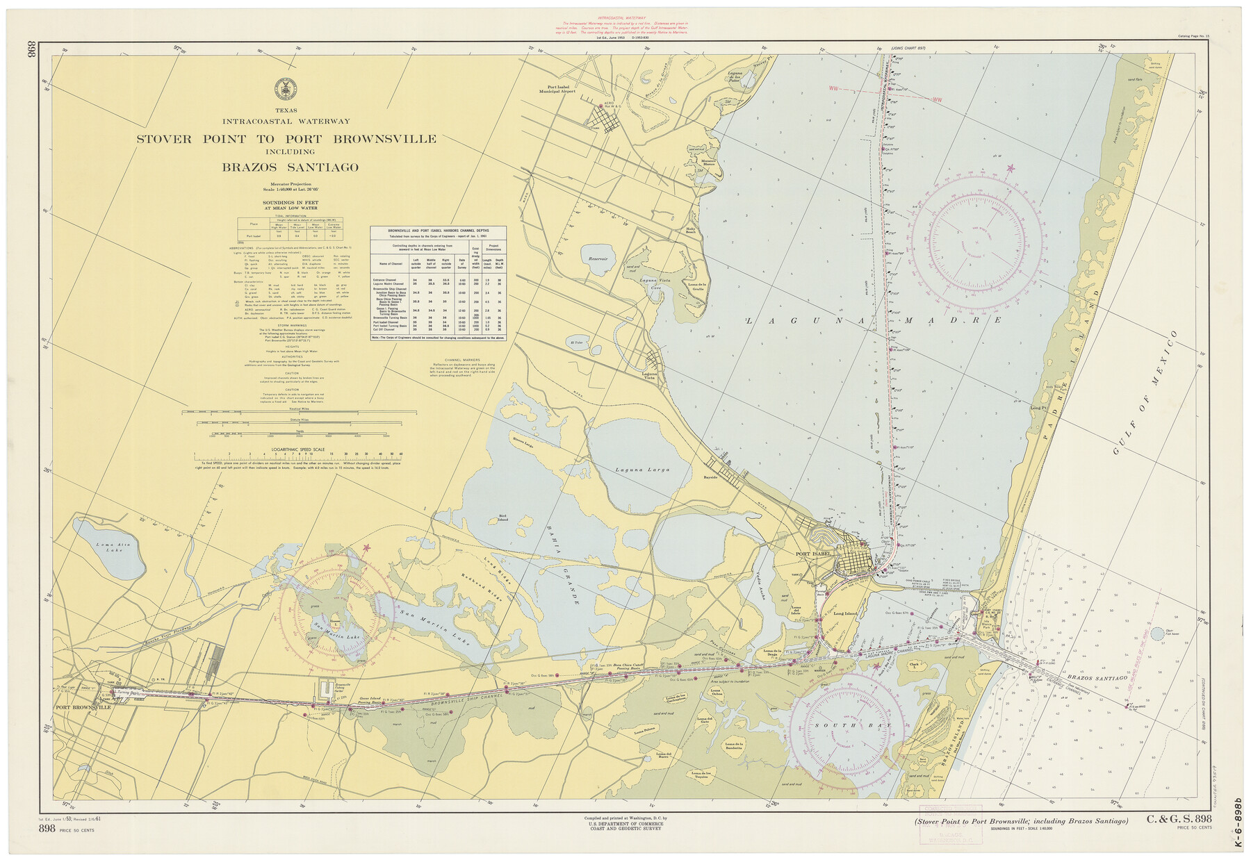
Texas Intracoastal Waterway - Stover Point to Port Brownsville including Brazos Santiago
K-6-898a
-
Map/Doc
73519
-
Collection
General Map Collection
-
Object Dates
2/6/1961 (Creation Date)
-
Counties
Cameron
-
Subjects
Nautical Charts
-
Height x Width
27.2 x 38.9 inches
69.1 x 98.8 cm
Part of: General Map Collection
Smith County Sketch File 2

Print $4.00
- Digital $50.00
Smith County Sketch File 2
1853
Size 12.7 x 8.5 inches
Map/Doc 36748
Borden County Working Sketch 7

Print $20.00
- Digital $50.00
Borden County Working Sketch 7
1947
Size 21.0 x 22.5 inches
Map/Doc 67467
Atascosa County Working Sketch 11

Print $20.00
- Digital $50.00
Atascosa County Working Sketch 11
1923
Size 13.9 x 17.1 inches
Map/Doc 67207
Map of Shackelford County, North of the Clearfork of the Brazos River Young - South of il Milam - Land District

Print $20.00
- Digital $50.00
Map of Shackelford County, North of the Clearfork of the Brazos River Young - South of il Milam - Land District
1859
Size 24.8 x 19.9 inches
Map/Doc 4027
Dimmit County Working Sketch 53

Print $20.00
- Digital $50.00
Dimmit County Working Sketch 53
1990
Size 25.5 x 26.0 inches
Map/Doc 68714
Gregg County Rolled Sketch 7A

Print $20.00
- Digital $50.00
Gregg County Rolled Sketch 7A
1932
Size 22.6 x 39.2 inches
Map/Doc 6033
[Liberty County, Texas]
![60297, [Liberty County, Texas], General Map Collection](https://historictexasmaps.com/wmedia_w700/maps/60297-1.tif.jpg)
Print $20.00
- Digital $50.00
[Liberty County, Texas]
1890
Size 24.2 x 16.9 inches
Map/Doc 60297
Flight Mission No. DQN-2K, Frame 142, Calhoun County

Print $20.00
- Digital $50.00
Flight Mission No. DQN-2K, Frame 142, Calhoun County
1953
Size 16.3 x 16.0 inches
Map/Doc 84311
Nacogdoches County Working Sketch 12

Print $20.00
- Digital $50.00
Nacogdoches County Working Sketch 12
1997
Size 44.9 x 34.9 inches
Map/Doc 71228
San Patricio County Working Sketch 25

Print $20.00
- Digital $50.00
San Patricio County Working Sketch 25
1951
Size 20.3 x 25.4 inches
Map/Doc 63787
Pecos County Working Sketch 36

Print $20.00
- Digital $50.00
Pecos County Working Sketch 36
1939
Size 47.4 x 38.8 inches
Map/Doc 71508
Harris County NRC Article 33.136 Location Key Sheet

Print $20.00
- Digital $50.00
Harris County NRC Article 33.136 Location Key Sheet
1995
Size 27.0 x 21.8 inches
Map/Doc 82992
You may also like
Right of Way & Track Map, San Antonio & Aransas Pass Railway Co.

Print $40.00
- Digital $50.00
Right of Way & Track Map, San Antonio & Aransas Pass Railway Co.
1919
Size 25.3 x 56.5 inches
Map/Doc 64213
Coast of Texas from head of East Bay Galveston Harbor to Sabine Pass

Print $40.00
- Digital $50.00
Coast of Texas from head of East Bay Galveston Harbor to Sabine Pass
1882
Size 32.3 x 53.9 inches
Map/Doc 69840
[Northwest part of County]
![90616, [Northwest part of County], Twichell Survey Records](https://historictexasmaps.com/wmedia_w700/maps/90616-1.tif.jpg)
Print $20.00
- Digital $50.00
[Northwest part of County]
Size 17.4 x 22.5 inches
Map/Doc 90616

Flight Mission No. CLL-1N, Frame 38, Willacy County

Print $20.00
- Digital $50.00
Flight Mission No. CLL-1N, Frame 38, Willacy County
1954
Size 18.4 x 22.1 inches
Map/Doc 87019
Loving County Working Sketch 7

Print $20.00
- Digital $50.00
Loving County Working Sketch 7
1949
Size 23.4 x 26.3 inches
Map/Doc 70639
Stonewall County Rolled Sketch 25

Print $20.00
- Digital $50.00
Stonewall County Rolled Sketch 25
1952
Size 27.8 x 22.1 inches
Map/Doc 7873
Map of Young County East of the Main Brazos River formerly Fannin and West of it Milam Land District

Print $20.00
- Digital $50.00
Map of Young County East of the Main Brazos River formerly Fannin and West of it Milam Land District
1859
Size 23.3 x 20.2 inches
Map/Doc 4173
Amistad International Reservoir on Rio Grande 79

Print $20.00
- Digital $50.00
Amistad International Reservoir on Rio Grande 79
1949
Size 28.6 x 40.3 inches
Map/Doc 75508
Hutchinson County Rolled Sketch 37A

Print $40.00
- Digital $50.00
Hutchinson County Rolled Sketch 37A
1950
Size 24.7 x 50.5 inches
Map/Doc 9246
Intracoastal Waterway in Texas - Corpus Christi to Point Isabel including Arroyo Colorado to Mo. Pac. R.R. Bridge Near Harlingen

Print $20.00
- Digital $50.00
Intracoastal Waterway in Texas - Corpus Christi to Point Isabel including Arroyo Colorado to Mo. Pac. R.R. Bridge Near Harlingen
1933
Size 28.0 x 40.8 inches
Map/Doc 61849
[John S. Stephens Blk. S-2, J. A. Oden Blk. 1, Lgs. 174-176]
![90247, [John S. Stephens Blk. S-2, J. A. Oden Blk. 1, Lgs. 174-176], Twichell Survey Records](https://historictexasmaps.com/wmedia_w700/maps/90247-1.tif.jpg)
Print $20.00
- Digital $50.00
[John S. Stephens Blk. S-2, J. A. Oden Blk. 1, Lgs. 174-176]
1913
Size 24.8 x 31.5 inches
Map/Doc 90247