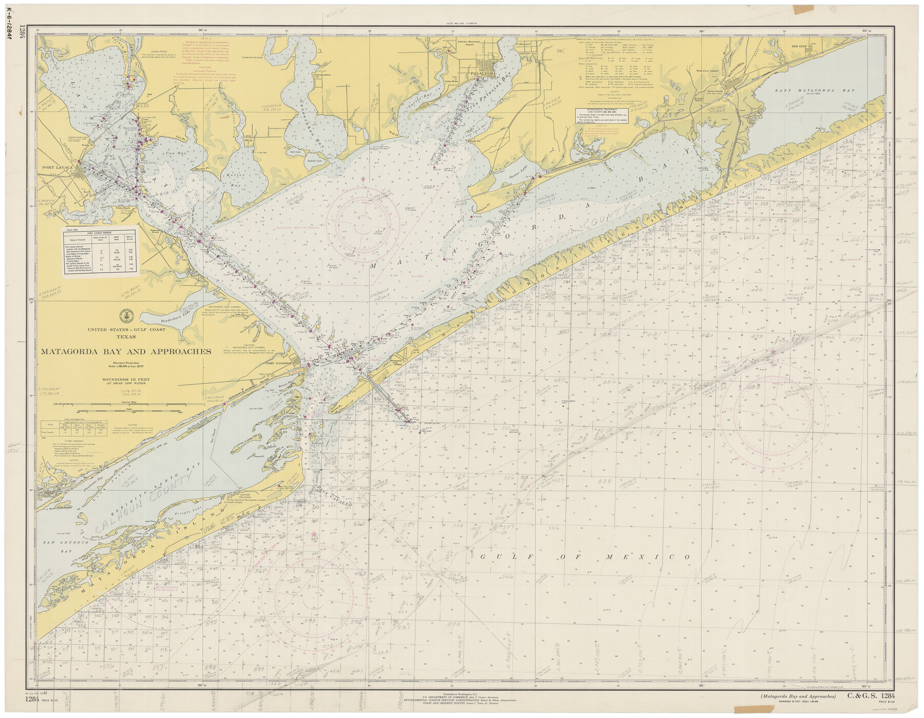
Matagorda Bay and Approaches
K-6-1284a
- 
                          Map/Doc
73383
 - 
                            Collection
General Map Collection
 - 
                            Object Dates
11/22/1965 (Creation Date)
 - 
                            Counties
Matagorda Calhoun Victoria Jackson
 - 
                            Subjects
Nautical Charts
 - 
                            Height x Width
34.8 x 44.9 inches
88.4 x 114.1 cm
 
Part of: General Map Collection
            Duval County Working Sketch 46


                                            Print $20.00                    
                                             -                         Digital $50.00                                    
                Duval County Working Sketch 46
1980
Size 29.4 x 27.2 inches
                                Map/Doc 68770
            
            Pecos County Working Sketch 48


                                            Print $20.00                    
                                             -                         Digital $50.00                                    
                Pecos County Working Sketch 48
1947
Size 35.0 x 27.7 inches
                                Map/Doc 71520
            
            Terrell County Rolled Sketch 45


                                            Print $40.00                    
                                             -                         Digital $50.00                                    
                Terrell County Rolled Sketch 45
1953
Size 33.5 x 51.7 inches
                                Map/Doc 9991
            
            Map Illustrating the plan of the defences of the Western & North-Western Frontier, as proposed by Charles Gratiot in his report of Oct. 31, 1837


                                            Print $20.00                    
                                             -                         Digital $50.00                                    
                Map Illustrating the plan of the defences of the Western & North-Western Frontier, as proposed by Charles Gratiot in his report of Oct. 31, 1837
1837
Size 23.8 x 17.7 inches
                                Map/Doc 95698
            
            Milam County Working Sketch Graphic Index


                                            Print $40.00                    
                                             -                         Digital $50.00                                    
                Milam County Working Sketch Graphic Index
1975
Size 51.6 x 42.7 inches
                                Map/Doc 76642
            
            Trace of a copy of the map captured at the battle of Resaca de la Palma


                                            Print $20.00                    
                                             -                         Digital $50.00                                    
                Trace of a copy of the map captured at the battle of Resaca de la Palma
Size 18.3 x 27.3 inches
                                Map/Doc 73054
            
            Val Verde County Sketch File 5


                                            Print $10.00                    
                                             -                         Digital $50.00                                    
                Val Verde County Sketch File 5
1889
Size 11.3 x 8.4 inches
                                Map/Doc 39180
            
            Presidio County Working Sketch 50


                                            Print $20.00                    
                                             -                         Digital $50.00                                    
                Presidio County Working Sketch 50
1953
Size 45.2 x 41.5 inches
                                Map/Doc 71727
            
            Northwest Part Pecos County


                                            Print $20.00                    
                                             -                         Digital $50.00                                    
                Northwest Part Pecos County
1975
Size 42.4 x 43.1 inches
                                Map/Doc 73261
            
            [Right of Way and Track Map, the Missouri, Kansas and Texas Ry. of Texas - Henrietta Division]


                                            Print $20.00                    
                                             -                         Digital $50.00                                    
                [Right of Way and Track Map, the Missouri, Kansas and Texas Ry. of Texas - Henrietta Division]
1918
Size 11.8 x 26.9 inches
                                Map/Doc 64757
            You may also like
            Conoco Official Road Map New Mexico


                                            Print $20.00                    
                                             -                         Digital $50.00                                    
                Conoco Official Road Map New Mexico
1934
Size 18.5 x 24.5 inches
                                Map/Doc 92437
            
            Leon County Rolled Sketch 21


                                            Print $20.00                    
                                             -                         Digital $50.00                                    
                Leon County Rolled Sketch 21
Size 33.5 x 24.3 inches
                                Map/Doc 75971
            
            [Area around Gillespie County, Bastrop County and El Paso County School Land Leagues]


                                            Print $20.00                    
                                             -                         Digital $50.00                                    
                [Area around Gillespie County, Bastrop County and El Paso County School Land Leagues]
1886
Size 25.7 x 29.8 inches
                                Map/Doc 90866
            
            Travis County Sketch File 75B


                                            Print $20.00                    
                                             -                         Digital $50.00                                    
                Travis County Sketch File 75B
1992
Size 37.4 x 26.7 inches
                                Map/Doc 12479
            
            Reeves County Working Sketch 17


                                            Print $20.00                    
                                             -                         Digital $50.00                                    
                Reeves County Working Sketch 17
1961
Size 30.2 x 30.9 inches
                                Map/Doc 63460
            
            Edwards County Sketch File 16b


                                            Print $56.00                    
                                             -                         Digital $50.00                                    
                Edwards County Sketch File 16b
1907
Size 9.4 x 8.7 inches
                                Map/Doc 21722
            
            Flight Mission No. BRA-6M, Frame 92, Jefferson County


                                            Print $20.00                    
                                             -                         Digital $50.00                                    
                Flight Mission No. BRA-6M, Frame 92, Jefferson County
1953
Size 18.5 x 22.3 inches
                                Map/Doc 85435
            
            Gregg County Sketch File 16


                                            Print $6.00                    
                                             -                         Digital $50.00                                    
                Gregg County Sketch File 16
1931
Size 17.0 x 11.0 inches
                                Map/Doc 24619
            
            Kerr County Working Sketch 30


                                            Print $20.00                    
                                             -                         Digital $50.00                                    
                Kerr County Working Sketch 30
1973
Size 29.8 x 28.9 inches
                                Map/Doc 70061
            
            Brewster County Working Sketch 72


                                            Print $20.00                    
                                             -                         Digital $50.00                                    
                Brewster County Working Sketch 72
1965
Size 20.7 x 24.6 inches
                                Map/Doc 67672
            
            Boundary Between the United States & Mexico Agreed Upon by the Joint Commission under the Treaty of Guadalupe Hidalgo


                                            Print $20.00                    
                                             -                         Digital $50.00                                    
                Boundary Between the United States & Mexico Agreed Upon by the Joint Commission under the Treaty of Guadalupe Hidalgo
1853
Size 24.0 x 18.3 inches
                                Map/Doc 65396
            
            Bandera County Working Sketch 36


                                            Print $20.00                    
                                             -                         Digital $50.00                                    
                Bandera County Working Sketch 36
1966
Size 22.5 x 29.5 inches
                                Map/Doc 67632