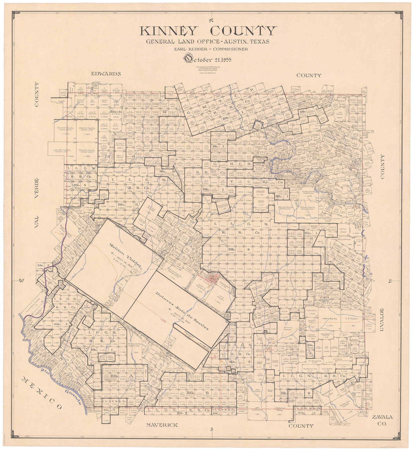
Kinney County
-
Map/Doc
73209
-
Collection
General Map Collection
-
Object Dates
1955/10/21 (Creation Date)
-
People and Organizations
Texas General Land Office (Publisher)
Herman H. Forbes Jr. (Compiler)
J. Earl Rudder (GLO Commissioner)
Tommye Buie (Draftsman)
W. S. Brewington (Compiler)
-
Counties
Kinney
-
Subjects
County
-
Height x Width
50.5 x 47.0 inches
128.3 x 119.4 cm
-
Comments
Hand lettered.
-
Features
Kinney [Station]
Chaparesca Creek
Muela Creek
Salado Creek
Dixie
Rio Grande
Lindsey Creek
Elm Creek
Anacacho [Station]
Spofford
Tequesquite Creek
Las Moras Creek
West Prong of Sycamore Creek
Cow Creek
Old Fort Clark
Brackettville
Mud Creek
Piedra Pinta Creek
Grass Valley Creek
Sycamore Creek
Nueces River
West Prong of Nueces River
Silver Lake
[Battle]
Part of: General Map Collection
Flight Mission No. DAG-21K, Frame 128, Matagorda County

Print $20.00
- Digital $50.00
Flight Mission No. DAG-21K, Frame 128, Matagorda County
1952
Size 18.4 x 22.3 inches
Map/Doc 86454
Chambers County Rolled Sketch 24

Print $40.00
- Digital $50.00
Chambers County Rolled Sketch 24
1940
Size 38.2 x 49.9 inches
Map/Doc 8594
Flight Mission No. DCL-7C, Frame 135, Kenedy County

Print $20.00
- Digital $50.00
Flight Mission No. DCL-7C, Frame 135, Kenedy County
1943
Size 15.5 x 15.3 inches
Map/Doc 86092
Hardin County Sketch File 54

Print $20.00
- Digital $50.00
Hardin County Sketch File 54
1924
Size 16.6 x 17.9 inches
Map/Doc 11635
Dickens County Working Sketch 14

Print $20.00
- Digital $50.00
Dickens County Working Sketch 14
1986
Size 25.5 x 30.7 inches
Map/Doc 62180
Hutchinson County Sketch File 44

Print $82.00
- Digital $50.00
Hutchinson County Sketch File 44
1989
Size 11.2 x 9.0 inches
Map/Doc 27311
Sutton County Working Sketch 18

Print $20.00
- Digital $50.00
Sutton County Working Sketch 18
1978
Size 39.9 x 31.5 inches
Map/Doc 62361

Matagorda County NRC Article 33.136 Sketch 20

Print $106.00
Matagorda County NRC Article 33.136 Sketch 20
2024
Map/Doc 97425
Flight Mission No. BRE-2P, Frame 77, Nueces County

Print $20.00
- Digital $50.00
Flight Mission No. BRE-2P, Frame 77, Nueces County
1956
Size 18.4 x 22.2 inches
Map/Doc 86772

Chambers County Sketch File 15

Print $4.00
- Digital $50.00
Chambers County Sketch File 15
Size 8.3 x 12.4 inches
Map/Doc 17563
You may also like
Railroad and County Map of Texas

Print $20.00
Railroad and County Map of Texas
1903
Size 33.5 x 37.4 inches
Map/Doc 76224
Flight Mission No. CRC-4R, Frame 162, Chambers County

Print $20.00
- Digital $50.00
Flight Mission No. CRC-4R, Frame 162, Chambers County
1956
Size 18.6 x 22.4 inches
Map/Doc 84921
Map of Texas with population and location of principal towns and cities according to latest reliable statistics

Print $20.00
- Digital $50.00
Map of Texas with population and location of principal towns and cities according to latest reliable statistics
1908
Size 18.6 x 20.5 inches
Map/Doc 95872
Moore County Sketch File 14

Print $4.00
- Digital $50.00
Moore County Sketch File 14
Size 11.2 x 8.8 inches
Map/Doc 31961
Zavala County Working Sketch 18

Print $20.00
- Digital $50.00
Zavala County Working Sketch 18
1977
Size 43.8 x 42.1 inches
Map/Doc 62093
Val Verde County Rolled Sketch 70

Print $20.00
- Digital $50.00
Val Verde County Rolled Sketch 70
1958
Size 23.2 x 18.8 inches
Map/Doc 8132
Sabine Pass and Lake

Print $20.00
- Digital $50.00
Sabine Pass and Lake
1961
Size 46.7 x 28.1 inches
Map/Doc 69824
[Blocks D, Q, and Z]
![92522, [Blocks D, Q, and Z], Twichell Survey Records](https://historictexasmaps.com/wmedia_w700/maps/92522-1.tif.jpg)
Print $20.00
- Digital $50.00
[Blocks D, Q, and Z]
Size 17.9 x 22.6 inches
Map/Doc 92522

Harris County Historic Topographic 27

Print $20.00
- Digital $50.00
Harris County Historic Topographic 27
1915
Size 19.8 x 23.5 inches
Map/Doc 65838
Harris County Rolled Sketch 28

Print $20.00
- Digital $50.00
Harris County Rolled Sketch 28
Size 29.8 x 47.3 inches
Map/Doc 6095
Hutchinson County Rolled Sketch 37

Print $20.00
- Digital $50.00
Hutchinson County Rolled Sketch 37
1950
Size 24.4 x 44.4 inches
Map/Doc 6296