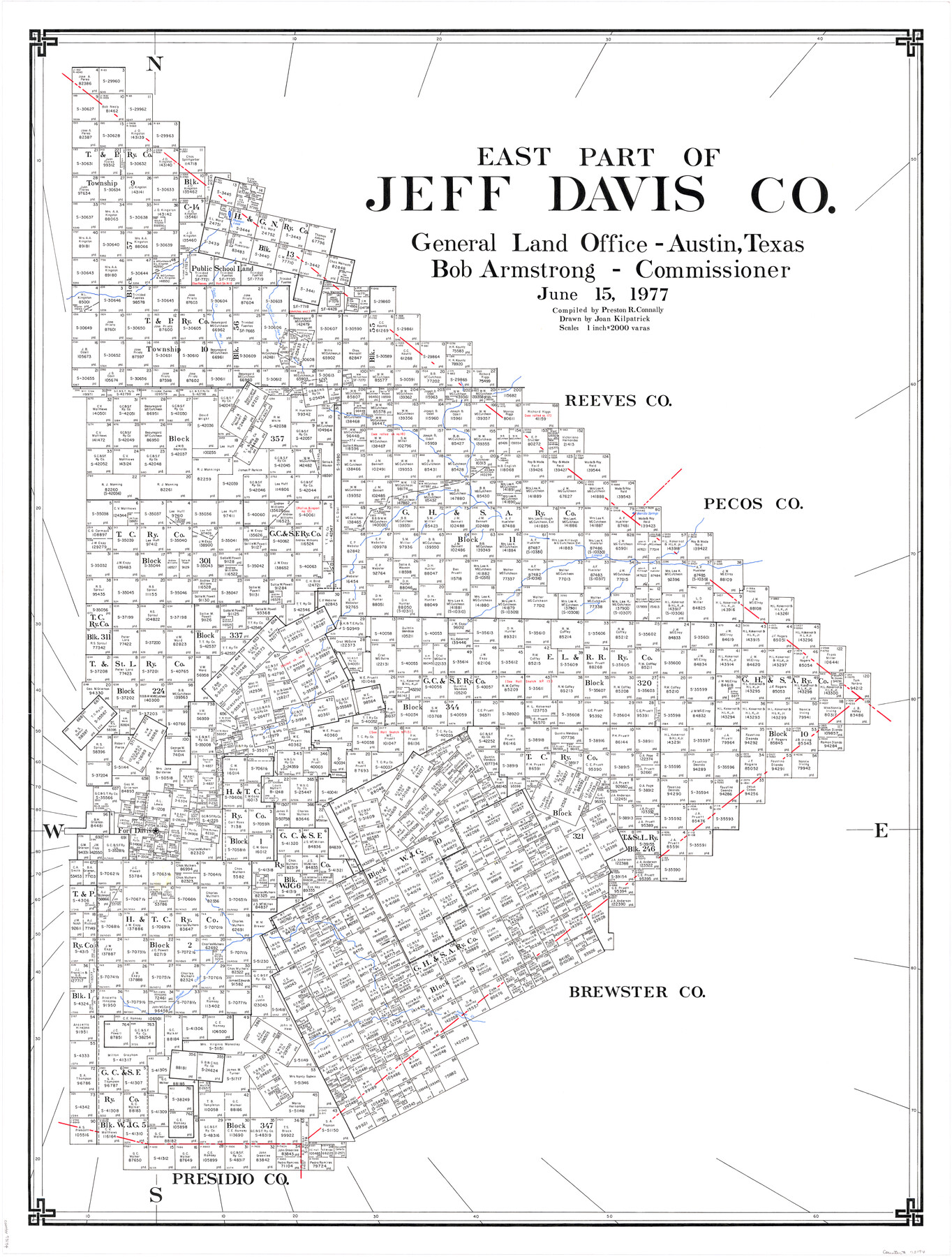
East Part of Jeff Davis Co.
-
Map/Doc
73194
-
Collection
General Map Collection
-
Object Dates
6/15/1977 (Creation Date)
-
People and Organizations
Preston R. Connally (Compiler)
Bob Armstrong (GLO Commissioner)
Joan Kilpatrick (Draftsman)
-
Counties
Jeff Davis
-
Subjects
County
-
Height x Width
46.4 x 35.7 inches
117.9 x 90.7 cm
-
Scale
1" = 2000 varas
-
Comments
Leroy lettered.
-
Features
Phantom Lake
Middle Fork of Toyah Creek
South Fork of Toyah Creek
Barrillo Springs
Limpia Creek
Fort Davis
Fort Davis
Musquiz Cañon
Paisano Creek
Part of: General Map Collection
Refugio County Working Sketch 11

Print $20.00
- Digital $50.00
Refugio County Working Sketch 11
1942
Size 40.9 x 38.3 inches
Map/Doc 63520
Sutton County Working Sketch 39

Print $20.00
- Digital $50.00
Sutton County Working Sketch 39
1945
Size 29.6 x 25.8 inches
Map/Doc 62382
Hays County Sketch File 12

Print $4.00
- Digital $50.00
Hays County Sketch File 12
1866
Size 8.5 x 7.2 inches
Map/Doc 26218
Township 4 South Ranges 12 and 13 West, South Western District, Louisiana

Print $2.00
- Digital $50.00
Township 4 South Ranges 12 and 13 West, South Western District, Louisiana
1968
Size 10.5 x 7.6 inches
Map/Doc 65889
Hunt County Rolled Sketch 5

Print $20.00
- Digital $50.00
Hunt County Rolled Sketch 5
1956
Size 28.6 x 24.3 inches
Map/Doc 6268
San Patricio County Sketch File 50

Print $8.00
- Digital $50.00
San Patricio County Sketch File 50
1873
Size 14.4 x 8.8 inches
Map/Doc 36371
Galveston County NRC Article 33.136 Sketch 58

Print $26.00
- Digital $50.00
Galveston County NRC Article 33.136 Sketch 58
2009
Size 12.0 x 17.6 inches
Map/Doc 94592
Pecos County Working Sketch 101

Print $20.00
- Digital $50.00
Pecos County Working Sketch 101
1970
Size 43.3 x 31.1 inches
Map/Doc 71574
Atascosa County Working Sketch 22

Print $20.00
- Digital $50.00
Atascosa County Working Sketch 22
1956
Size 31.6 x 25.5 inches
Map/Doc 67218
Colorado County Sketch File 14

Print $8.00
- Digital $50.00
Colorado County Sketch File 14
1874
Size 12.8 x 8.0 inches
Map/Doc 18939
Henderson County Working Sketch 5

Print $20.00
- Digital $50.00
Henderson County Working Sketch 5
1918
Size 19.2 x 23.5 inches
Map/Doc 66138
Map of the Houston & Great Northern Railroad

Print $40.00
- Digital $50.00
Map of the Houston & Great Northern Railroad
1871
Size 29.3 x 122.1 inches
Map/Doc 64551
You may also like
Midland County Rolled Sketch 14

Print $40.00
- Digital $50.00
Midland County Rolled Sketch 14
Size 102.9 x 43.8 inches
Map/Doc 73579
Parker County Working Sketch 12

Print $20.00
- Digital $50.00
Parker County Working Sketch 12
1974
Map/Doc 71462
Flight Mission No. CRC-3R, Frame 10, Chambers County

Print $20.00
- Digital $50.00
Flight Mission No. CRC-3R, Frame 10, Chambers County
1956
Size 18.5 x 22.2 inches
Map/Doc 84784
Harris County Rolled Sketch 86

Print $40.00
- Digital $50.00
Harris County Rolled Sketch 86
Size 50.4 x 43.9 inches
Map/Doc 73581
Blanco County Working Sketch 1

Print $20.00
- Digital $50.00
Blanco County Working Sketch 1
Size 31.1 x 17.4 inches
Map/Doc 76449
Swisher County Sketch File 1

Print $28.00
- Digital $50.00
Swisher County Sketch File 1
1884
Size 13.0 x 8.2 inches
Map/Doc 37566
Marion County Boundary File 1

Print $14.00
- Digital $50.00
Marion County Boundary File 1
Size 12.9 x 8.2 inches
Map/Doc 56822
Haskell County Sketch File 24

Print $20.00
- Digital $50.00
Haskell County Sketch File 24
Size 17.8 x 28.5 inches
Map/Doc 11747
Potter County Sketch File 13

Print $20.00
- Digital $50.00
Potter County Sketch File 13
Size 21.6 x 16.6 inches
Map/Doc 12199
Schleicher County Sketch File 42

Print $40.00
- Digital $50.00
Schleicher County Sketch File 42
1963
Size 16.3 x 14.4 inches
Map/Doc 36546
Burnet County Sketch File 39

Print $40.00
- Digital $50.00
Burnet County Sketch File 39
Size 9.6 x 24.1 inches
Map/Doc 11028
