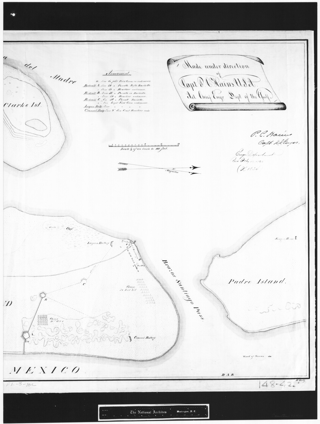
Map of north end of Brazos Island
RL-3-10c
-
Map/Doc
72920
-
Collection
General Map Collection
-
Object Dates
1845 (Creation Date)
-
People and Organizations
Department of the Gulf (Author)
H. Holtz (Draftsman)
-
Subjects
Gulf of Mexico
-
Height x Width
24.2 x 18.3 inches
61.5 x 46.5 cm
-
Comments
B/W photostat copy from National Archives in multiple pieces.
Part of: General Map Collection
Map of Goliad County

Print $20.00
- Digital $50.00
Map of Goliad County
1853
Size 30.7 x 24.2 inches
Map/Doc 3585
Eastland County Sketch File 9

Print $4.00
- Digital $50.00
Eastland County Sketch File 9
Size 10.5 x 8.2 inches
Map/Doc 21580
Brewster County Rolled Sketch 158

Print $20.00
- Digital $50.00
Brewster County Rolled Sketch 158
2007
Size 24.6 x 36.5 inches
Map/Doc 89623
Wise County Sketch File 1

Print $4.00
- Digital $50.00
Wise County Sketch File 1
1855
Size 11.9 x 7.6 inches
Map/Doc 40521
Pecos County Rolled Sketch 114

Print $856.00
- Digital $50.00
Pecos County Rolled Sketch 114
1942
Size 11.0 x 15.4 inches
Map/Doc 48104
[Sketch for Mineral Application 11108 - Greens Bayou]
![2786, [Sketch for Mineral Application 11108 - Greens Bayou], General Map Collection](https://historictexasmaps.com/wmedia_w700/maps/2786-1.tif.jpg)
Print $20.00
- Digital $50.00
[Sketch for Mineral Application 11108 - Greens Bayou]
1922
Size 46.0 x 21.0 inches
Map/Doc 2786
Swisher County Working Sketch 6

Print $20.00
- Digital $50.00
Swisher County Working Sketch 6
1979
Size 23.2 x 19.7 inches
Map/Doc 62417
Ector County Sketch File 5

Print $6.00
- Digital $50.00
Ector County Sketch File 5
1939
Size 9.1 x 14.5 inches
Map/Doc 21637
Galveston County

Print $40.00
- Digital $50.00
Galveston County
1939
Size 44.0 x 55.5 inches
Map/Doc 73155
Flight Mission No. DQN-1K, Frame 125, Calhoun County

Print $20.00
- Digital $50.00
Flight Mission No. DQN-1K, Frame 125, Calhoun County
1953
Size 18.4 x 22.1 inches
Map/Doc 84191
Flight Mission No. DAH-17M, Frame 21, Orange County

Print $20.00
- Digital $50.00
Flight Mission No. DAH-17M, Frame 21, Orange County
1953
Size 18.6 x 22.5 inches
Map/Doc 86884
Stonewall County Working Sketch 14

Print $20.00
- Digital $50.00
Stonewall County Working Sketch 14
1951
Size 22.2 x 37.1 inches
Map/Doc 62321
You may also like
Jack County Sketch File 24

Print $4.00
- Digital $50.00
Jack County Sketch File 24
1880
Size 8.3 x 9.5 inches
Map/Doc 27561
Wheeler County Working Sketch 10

Print $40.00
- Digital $50.00
Wheeler County Working Sketch 10
1973
Size 72.4 x 36.6 inches
Map/Doc 72499
Map of R. H. Welder Ranch, San Patricio County, Texas

Print $40.00
- Digital $50.00
Map of R. H. Welder Ranch, San Patricio County, Texas
1953
Size 30.0 x 61.4 inches
Map/Doc 61406
Henderson County Sketch File 22

Print $14.00
- Digital $50.00
Henderson County Sketch File 22
1942
Size 14.2 x 8.9 inches
Map/Doc 26365
Hall County Working Sketch Graphic Index

Print $20.00
- Digital $50.00
Hall County Working Sketch Graphic Index
1972
Size 41.7 x 33.7 inches
Map/Doc 76563
Lavaca County Sketch File 3

Print $8.00
- Digital $50.00
Lavaca County Sketch File 3
1853
Size 10.1 x 9.8 inches
Map/Doc 29633
Upton County Sketch File 10

Print $18.00
- Digital $50.00
Upton County Sketch File 10
1919
Size 13.5 x 8.7 inches
Map/Doc 38839
Willacy County Rolled Sketch 2

Print $40.00
- Digital $50.00
Willacy County Rolled Sketch 2
1921
Size 30.7 x 62.9 inches
Map/Doc 10145
Part of Matagorda Bay & Peninsula, Texas

Print $40.00
- Digital $50.00
Part of Matagorda Bay & Peninsula, Texas
1856
Size 31.8 x 51.4 inches
Map/Doc 69978
Controlled Mosaic by Jack Amman Photogrammetric Engineers, Inc - Sheet 18

Print $20.00
- Digital $50.00
Controlled Mosaic by Jack Amman Photogrammetric Engineers, Inc - Sheet 18
1954
Size 19.4 x 24.0 inches
Map/Doc 83463
[S. M. Walker, D. P. Allen, J. C. Guinn, J. R. Lamar and surrounding surveys]
![90335, [S. M. Walker, D. P. Allen, J. C. Guinn, J. R. Lamar and surrounding surveys], Twichell Survey Records](https://historictexasmaps.com/wmedia_w700/maps/90335-1.tif.jpg)
Print $3.00
- Digital $50.00
[S. M. Walker, D. P. Allen, J. C. Guinn, J. R. Lamar and surrounding surveys]
1912
Size 9.8 x 11.3 inches
Map/Doc 90335
Dimmit County Sketch File 21

Print $16.00
- Digital $50.00
Dimmit County Sketch File 21
1898
Size 14.4 x 8.8 inches
Map/Doc 21115