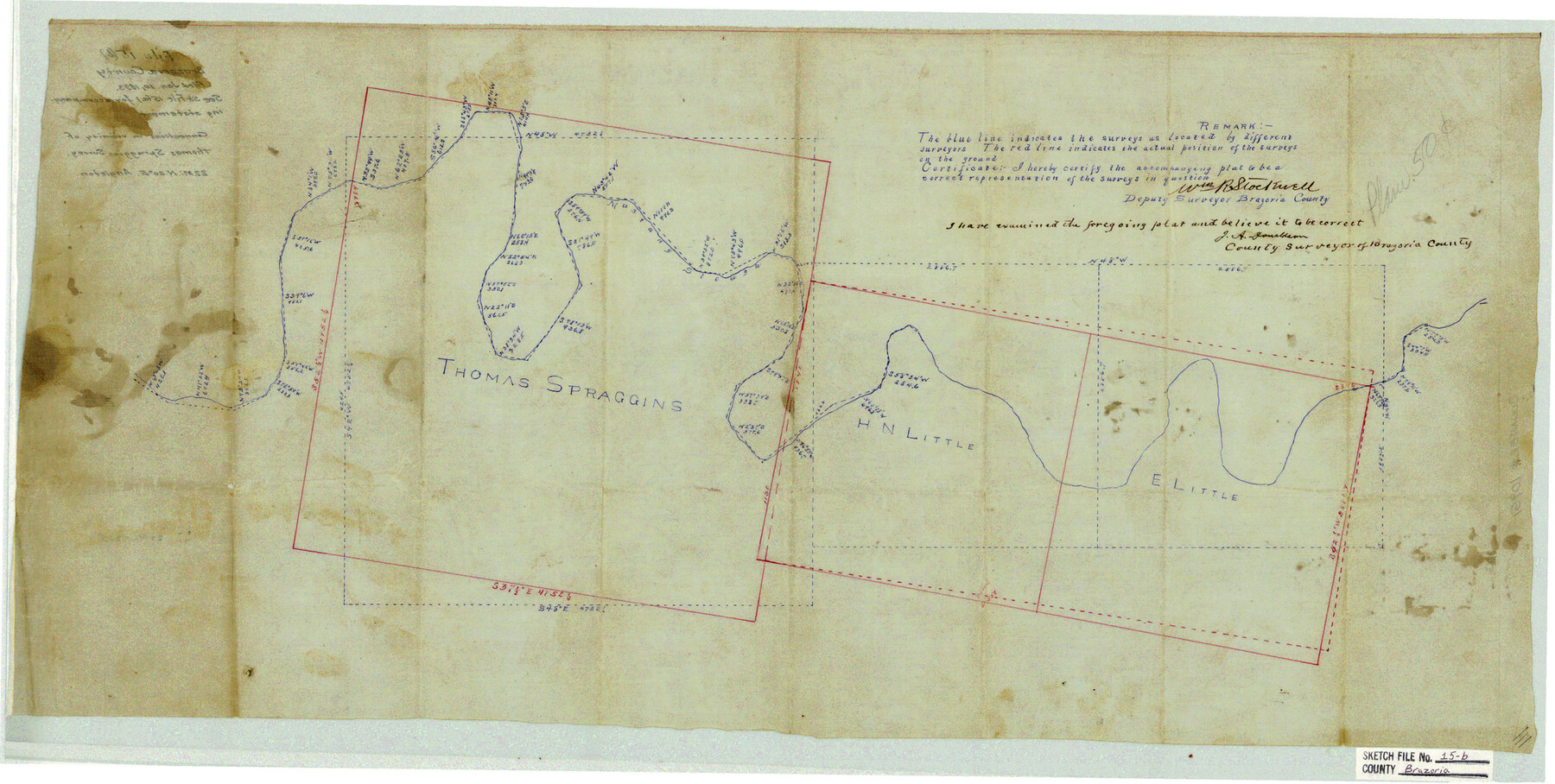
Brazoria County Sketch File 15b
[Sketch of Thomas Spraggins, H.N. Little, and E. Little surveys]
-
Map/Doc
10951
-
Collection
General Map Collection
-
Object Dates
1893/1/10 (File Date)
-
People and Organizations
William R. Stockwell (Surveyor/Engineer)
-
Counties
Brazoria
-
Subjects
Surveying Sketch File
-
Height x Width
13.2 x 26.3 inches
33.5 x 66.8 cm
-
Medium
linen, manuscript
-
Comments
See Brazoria County Sketch File 15 (14977) and Brazoria County Sketch File 15a (14979).
Related maps
Brazoria County Sketch File 15

Print $4.00
- Digital $50.00
Brazoria County Sketch File 15
1892
Size 12.8 x 8.4 inches
Map/Doc 14977
Brazoria County Sketch File 15a

Print $4.00
- Digital $50.00
Brazoria County Sketch File 15a
1892
Size 14.2 x 8.7 inches
Map/Doc 14979
Part of: General Map Collection
Borden County

Print $20.00
- Digital $50.00
Borden County
1892
Size 40.6 x 39.8 inches
Map/Doc 66716
Brewster County Sketch File NS-7

Print $14.00
- Digital $50.00
Brewster County Sketch File NS-7
1945
Size 11.3 x 8.8 inches
Map/Doc 15992
Flight Mission No. CRC-5R, Frame 39, Chambers County

Print $20.00
- Digital $50.00
Flight Mission No. CRC-5R, Frame 39, Chambers County
1956
Size 18.5 x 22.3 inches
Map/Doc 84958
Travis County Sketch File 78

Print $102.00
- Digital $50.00
Travis County Sketch File 78
2010
Size 11.0 x 8.5 inches
Map/Doc 90085
Yoakum County

Print $20.00
- Digital $50.00
Yoakum County
1932
Size 47.1 x 35.6 inches
Map/Doc 63139
Right of Way and Track Map - Houston & Texas Central R.R. operated by the T. and N. O. R.R. Co. - Fort Worth Branch

Print $40.00
- Digital $50.00
Right of Way and Track Map - Houston & Texas Central R.R. operated by the T. and N. O. R.R. Co. - Fort Worth Branch
1918
Size 25.3 x 57.3 inches
Map/Doc 82860
Stonewall County Rolled Sketch 18

Print $20.00
- Digital $50.00
Stonewall County Rolled Sketch 18
1950
Size 27.4 x 29.4 inches
Map/Doc 7872
San Patricio County Rolled Sketch 36

Print $40.00
- Digital $50.00
San Patricio County Rolled Sketch 36
Size 42.3 x 48.1 inches
Map/Doc 9899
Wood County Sketch File 15

Print $5.00
- Digital $50.00
Wood County Sketch File 15
1835
Size 11.0 x 16.3 inches
Map/Doc 40694
Bexar County Sketch File 61

Print $61.00
- Digital $50.00
Bexar County Sketch File 61
2019
Size 11.0 x 8.5 inches
Map/Doc 95709
Leon County Working Sketch 44

Print $40.00
- Digital $50.00
Leon County Working Sketch 44
1980
Size 42.8 x 59.8 inches
Map/Doc 70443
2016 Official Travel Map, Texas

2016 Official Travel Map, Texas
Size 33.3 x 36.2 inches
Map/Doc 94298
You may also like
Blanco County Boundary File 10

Print $26.00
- Digital $50.00
Blanco County Boundary File 10
Size 8.9 x 7.6 inches
Map/Doc 50576
A Geological Map of the United States and Canada

Print $20.00
A Geological Map of the United States and Canada
1853
Size 17.4 x 25.0 inches
Map/Doc 95189
Fort Bend County State Real Property Sketch 3

Print $40.00
- Digital $50.00
Fort Bend County State Real Property Sketch 3
1986
Size 34.5 x 43.6 inches
Map/Doc 61677
Pecos County Rolled Sketch 146A

Print $37.00
- Digital $50.00
Pecos County Rolled Sketch 146A
1957
Size 10.4 x 15.2 inches
Map/Doc 48396
Jasper County Sketch File 10

Print $4.00
- Digital $50.00
Jasper County Sketch File 10
1878
Size 9.1 x 8.6 inches
Map/Doc 27788
[Sketch of common corner of Oldham, Potter, Deaf Smith and Randall Counties]
![93060, [Sketch of common corner of Oldham, Potter, Deaf Smith and Randall Counties], Twichell Survey Records](https://historictexasmaps.com/wmedia_w700/maps/93060-1.tif.jpg)
Print $20.00
- Digital $50.00
[Sketch of common corner of Oldham, Potter, Deaf Smith and Randall Counties]
Size 17.2 x 33.1 inches
Map/Doc 93060
San Patricio County Working Sketch 1
Print $20.00
- Digital $50.00
San Patricio County Working Sketch 1
Size 25.2 x 26.2 inches
Map/Doc 63763
Map of Hays County

Print $20.00
- Digital $50.00
Map of Hays County
1877
Size 21.2 x 19.8 inches
Map/Doc 3646
Mapa del Presidio de San Antonio de Bexar, i sus Misiones de la Provinsia de Texas

Print $20.00
Mapa del Presidio de San Antonio de Bexar, i sus Misiones de la Provinsia de Texas
1764
Size 14.5 x 18.4 inches
Map/Doc 94455
Hopkins County

Print $20.00
- Digital $50.00
Hopkins County
1942
Size 45.7 x 42.2 inches
Map/Doc 95533
West Half of Sabine Lake, Jefferson County, showing Subdivision for Mineral Development; do not use; see Map 25a

Print $20.00
- Digital $50.00
West Half of Sabine Lake, Jefferson County, showing Subdivision for Mineral Development; do not use; see Map 25a
1956
Size 38.2 x 28.4 inches
Map/Doc 1930
Stonewall County Working Sketch 33

Print $40.00
- Digital $50.00
Stonewall County Working Sketch 33
1984
Size 70.4 x 42.8 inches
Map/Doc 62340