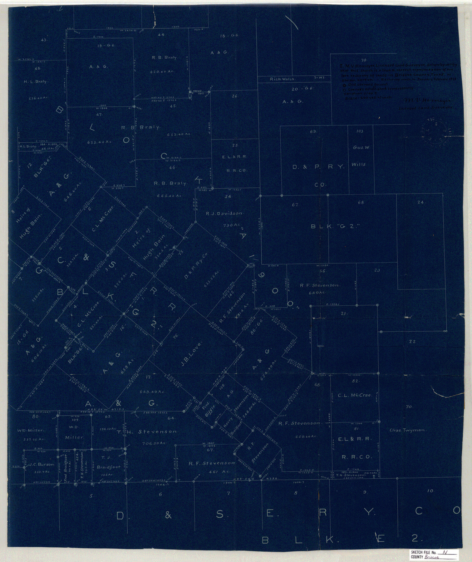
Briscoe County Sketch File N
[Sketch of parts of Blocks A-1900 and G2 in northeast part of county]
-
Map/Doc
11012
-
Collection
General Map Collection
-
Object Dates
1921/3/30 (File Date)
1921 (Survey Date)
-
People and Organizations
M.V. Homeyer (Surveyor/Engineer)
-
Counties
Briscoe
-
Subjects
Surveying Sketch File
-
Height x Width
26.0 x 21.9 inches
66.0 x 55.6 cm
-
Medium
blueprint/diazo
-
Scale
1" = 600 varas
Part of: General Map Collection
Red River County Rolled Sketch 3

Print $20.00
- Digital $50.00
Red River County Rolled Sketch 3
Size 36.9 x 31.0 inches
Map/Doc 9840
Uvalde County Boundary File 3

Print $28.00
- Digital $50.00
Uvalde County Boundary File 3
Size 13.1 x 8.4 inches
Map/Doc 59558
Jefferson County Sketch File 15b

Print $26.00
- Digital $50.00
Jefferson County Sketch File 15b
Size 17.4 x 33.2 inches
Map/Doc 11869
Angelina County Working Sketch 17

Print $20.00
- Digital $50.00
Angelina County Working Sketch 17
1942
Size 18.6 x 13.8 inches
Map/Doc 67098
Foard County Boundary File 3

Print $48.00
- Digital $50.00
Foard County Boundary File 3
Size 24.2 x 6.0 inches
Map/Doc 53516
Maps & Lists Showing Prison Lands (Oil & Gas) Leased as of June 1955

Digital $50.00
Maps & Lists Showing Prison Lands (Oil & Gas) Leased as of June 1955
Size 11.1 x 8.8 inches
Map/Doc 62873
Nautical Chart 885-SC Intracoastal Waterway - Ellender to Galveston Bay, Louisiana-Texas

Print $20.00
- Digital $50.00
Nautical Chart 885-SC Intracoastal Waterway - Ellender to Galveston Bay, Louisiana-Texas
1972
Size 15.9 x 26.8 inches
Map/Doc 75910
Flight Mission No. DQN-1K, Frame 153, Calhoun County

Print $20.00
- Digital $50.00
Flight Mission No. DQN-1K, Frame 153, Calhoun County
1953
Size 18.6 x 22.3 inches
Map/Doc 84212
Flight Mission No. DCL-6C, Frame 173, Kenedy County

Print $20.00
- Digital $50.00
Flight Mission No. DCL-6C, Frame 173, Kenedy County
1943
Size 18.6 x 22.4 inches
Map/Doc 85985
Amistad International Reservoir on Rio Grande 69

Print $20.00
- Digital $50.00
Amistad International Reservoir on Rio Grande 69
1949
Size 28.4 x 39.4 inches
Map/Doc 73355
Wichita County Sketch File 33

Print $6.00
- Digital $50.00
Wichita County Sketch File 33
1949
Size 11.0 x 17.0 inches
Map/Doc 40152
La Salle County Sketch File 14

Print $4.00
- Digital $50.00
La Salle County Sketch File 14
Size 6.4 x 6.7 inches
Map/Doc 29483
You may also like
Coke County Working Sketch 22

Print $20.00
- Digital $50.00
Coke County Working Sketch 22
1949
Size 21.7 x 27.7 inches
Map/Doc 68059
Kendall County Working Sketch 18

Print $20.00
- Digital $50.00
Kendall County Working Sketch 18
1970
Size 43.2 x 33.3 inches
Map/Doc 66690
Schleicher County Sketch File 29

Print $44.00
- Digital $50.00
Schleicher County Sketch File 29
1940
Size 31.9 x 23.7 inches
Map/Doc 12306
Hardin County Rolled Sketch 24

Print $20.00
- Digital $50.00
Hardin County Rolled Sketch 24
1998
Size 27.2 x 38.6 inches
Map/Doc 6092
Flight Mission No. DIX-6P, Frame 110, Aransas County

Print $20.00
- Digital $50.00
Flight Mission No. DIX-6P, Frame 110, Aransas County
1956
Size 19.7 x 23.4 inches
Map/Doc 83816
Dimmit County Sketch File 36

Print $6.00
- Digital $50.00
Dimmit County Sketch File 36
1894
Size 4.3 x 13.3 inches
Map/Doc 21158
Kimble County Rolled Sketch 27

Print $20.00
- Digital $50.00
Kimble County Rolled Sketch 27
1963
Size 23.9 x 39.4 inches
Map/Doc 6517
Burnet County Boundary File 12a

Print $8.00
- Digital $50.00
Burnet County Boundary File 12a
Size 12.9 x 8.7 inches
Map/Doc 50956
Navigation Maps of Gulf Intracoastal Waterway, Port Arthur to Brownsville, Texas

Print $4.00
- Digital $50.00
Navigation Maps of Gulf Intracoastal Waterway, Port Arthur to Brownsville, Texas
1951
Size 16.6 x 21.2 inches
Map/Doc 65445
Kerr County Working Sketch 32

Print $20.00
- Digital $50.00
Kerr County Working Sketch 32
1975
Size 33.8 x 25.3 inches
Map/Doc 70063
Goliad County Working Sketch 16

Print $20.00
- Digital $50.00
Goliad County Working Sketch 16
1949
Size 30.0 x 46.9 inches
Map/Doc 63206
Flight Mission No. BRE-2P, Frame 54, Nueces County

Print $20.00
- Digital $50.00
Flight Mission No. BRE-2P, Frame 54, Nueces County
1956
Size 18.5 x 22.4 inches
Map/Doc 86756