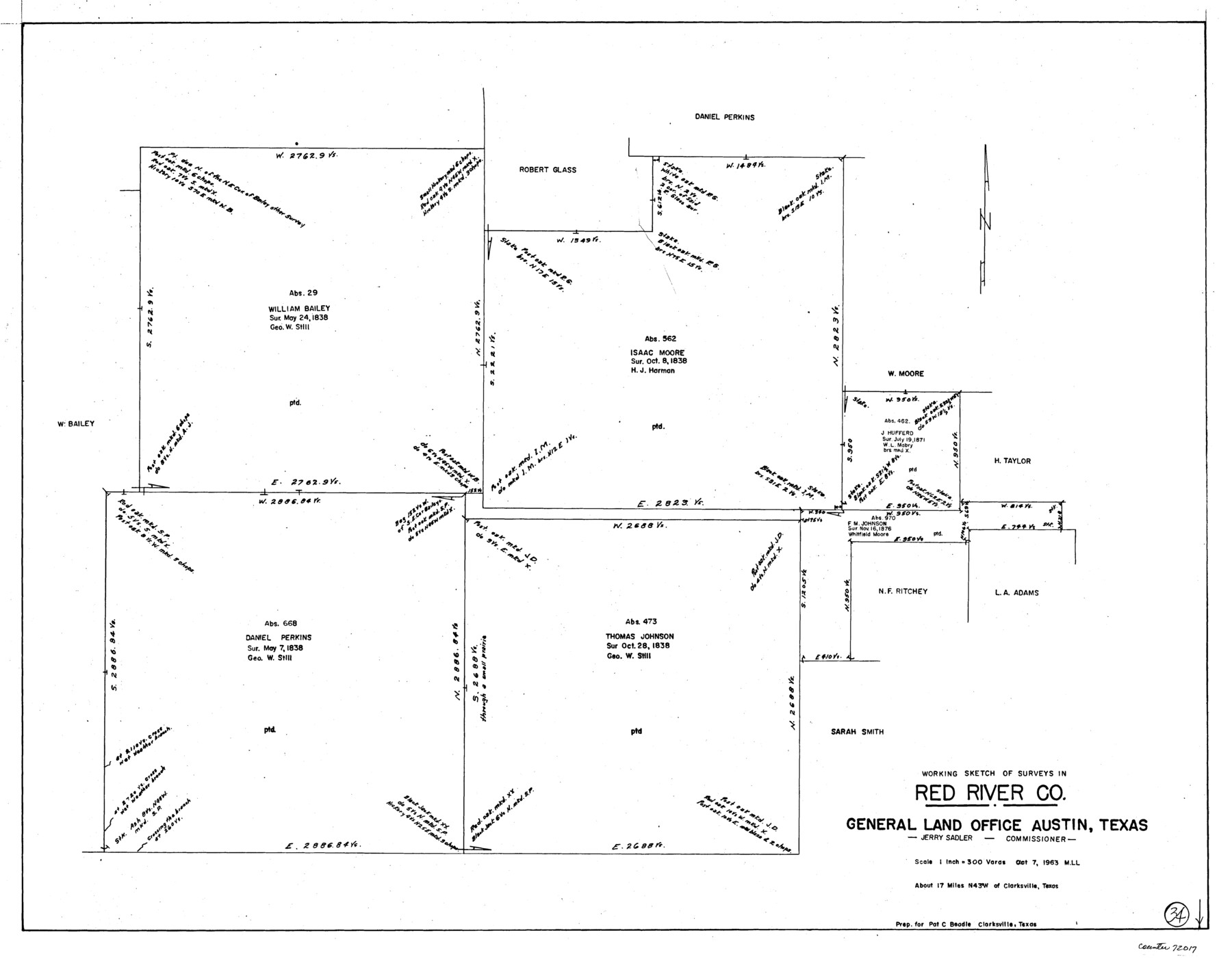
Red River County Working Sketch 34
-
Map/Doc
72017
-
Collection
General Map Collection
-
Object Dates
10/7/1963 (Creation Date)
-
People and Organizations
M. L. Liles (Draftsman)
-
Counties
Red River
-
Subjects
Surveying Working Sketch
-
Height x Width
25.8 x 33.1 inches
65.5 x 84.1 cm
-
Scale
1" = 300 varas
Part of: General Map Collection
Flight Mission No. CLL-1N, Frame 185, Willacy County

Print $20.00
- Digital $50.00
Flight Mission No. CLL-1N, Frame 185, Willacy County
1954
Size 18.4 x 22.1 inches
Map/Doc 87055

Galveston County Sketch File 72

Print $28.00
- Digital $50.00
Galveston County Sketch File 72
1995
Size 14.2 x 8.9 inches
Map/Doc 23970
Wise County Sketch File 31

Print $12.00
- Digital $50.00
Wise County Sketch File 31
1877
Size 13.1 x 8.1 inches
Map/Doc 40582
[San Antonio & Aransas Pass Railway Co.]
![64262, [San Antonio & Aransas Pass Railway Co.], General Map Collection](https://historictexasmaps.com/wmedia_w700/maps/64262-1.tif.jpg)
Print $40.00
- Digital $50.00
[San Antonio & Aransas Pass Railway Co.]
Size 15.7 x 86.4 inches
Map/Doc 64262
Wheeler County Sketch File A

Print $20.00
- Digital $50.00
Wheeler County Sketch File A
1888
Size 15.5 x 31.8 inches
Map/Doc 12677
Jim Wells County Boundary File 1

Print $22.00
- Digital $50.00
Jim Wells County Boundary File 1
Size 8.9 x 4.3 inches
Map/Doc 55531
Garza County Sketch File 23

Print $6.00
- Digital $50.00
Garza County Sketch File 23
1907
Size 11.3 x 8.7 inches
Map/Doc 24080
Fannin County Sketch File 15

Print $6.00
- Digital $50.00
Fannin County Sketch File 15
1866
Size 8.2 x 8.2 inches
Map/Doc 22466
Kenedy County Rolled Sketch 11

Print $20.00
- Digital $50.00
Kenedy County Rolled Sketch 11
1938
Size 40.5 x 30.2 inches
Map/Doc 6471
Bexar County Working Sketch 16

Print $20.00
- Digital $50.00
Bexar County Working Sketch 16
1978
Size 23.0 x 44.5 inches
Map/Doc 67332
[Sketch for Mineral Application 16700 - Pecos River Bed]
![2809, [Sketch for Mineral Application 16700 - Pecos River Bed], General Map Collection](https://historictexasmaps.com/wmedia_w700/maps/2809.tif.jpg)
Print $20.00
- Digital $50.00
[Sketch for Mineral Application 16700 - Pecos River Bed]
1927
Size 14.8 x 30.8 inches
Map/Doc 2809
You may also like
Crane County Rolled Sketch 23

Print $20.00
- Digital $50.00
Crane County Rolled Sketch 23
2002
Size 23.9 x 34.3 inches
Map/Doc 76426
Red River Co.

Print $20.00
- Digital $50.00
Red River Co.
1897
Size 46.8 x 36.0 inches
Map/Doc 16796
Chambers County Boundary File 1

Print $28.00
- Digital $50.00
Chambers County Boundary File 1
Size 8.9 x 6.7 inches
Map/Doc 51226
Nueces County Rolled Sketch 122

Print $47.00
Nueces County Rolled Sketch 122
1996
Size 24.6 x 40.2 inches
Map/Doc 7153
Brooks County Sketch File 9

Print $2.00
- Digital $50.00
Brooks County Sketch File 9
1988
Size 14.4 x 8.8 inches
Map/Doc 16571
Railroad and County Map of Texas

Print $20.00
Railroad and County Map of Texas
1901
Size 33.1 x 37.1 inches
Map/Doc 76213
Callahan County Sketch File 7

Print $18.00
- Digital $50.00
Callahan County Sketch File 7
Size 10.8 x 8.9 inches
Map/Doc 35863
Fort Bend County Working Sketch 12

Print $40.00
- Digital $50.00
Fort Bend County Working Sketch 12
1940
Size 29.9 x 73.2 inches
Map/Doc 69219
[Blocks JB, SI, K3, A, and S4]
![90776, [Blocks JB, SI, K3, A, and S4], Twichell Survey Records](https://historictexasmaps.com/wmedia_w700/maps/90776-1.tif.jpg)
Print $20.00
- Digital $50.00
[Blocks JB, SI, K3, A, and S4]
Size 23.6 x 15.2 inches
Map/Doc 90776
Hudspeth County Rolled Sketch 52

Print $20.00
- Digital $50.00
Hudspeth County Rolled Sketch 52
1975
Size 27.2 x 21.6 inches
Map/Doc 6257
Borden County Working Sketch 6

Print $20.00
- Digital $50.00
Borden County Working Sketch 6
1944
Size 24.6 x 23.0 inches
Map/Doc 67466
Fort Bend County Sketch File 27

Print $20.00
- Digital $50.00
Fort Bend County Sketch File 27
1910
Size 17.9 x 37.7 inches
Map/Doc 10453