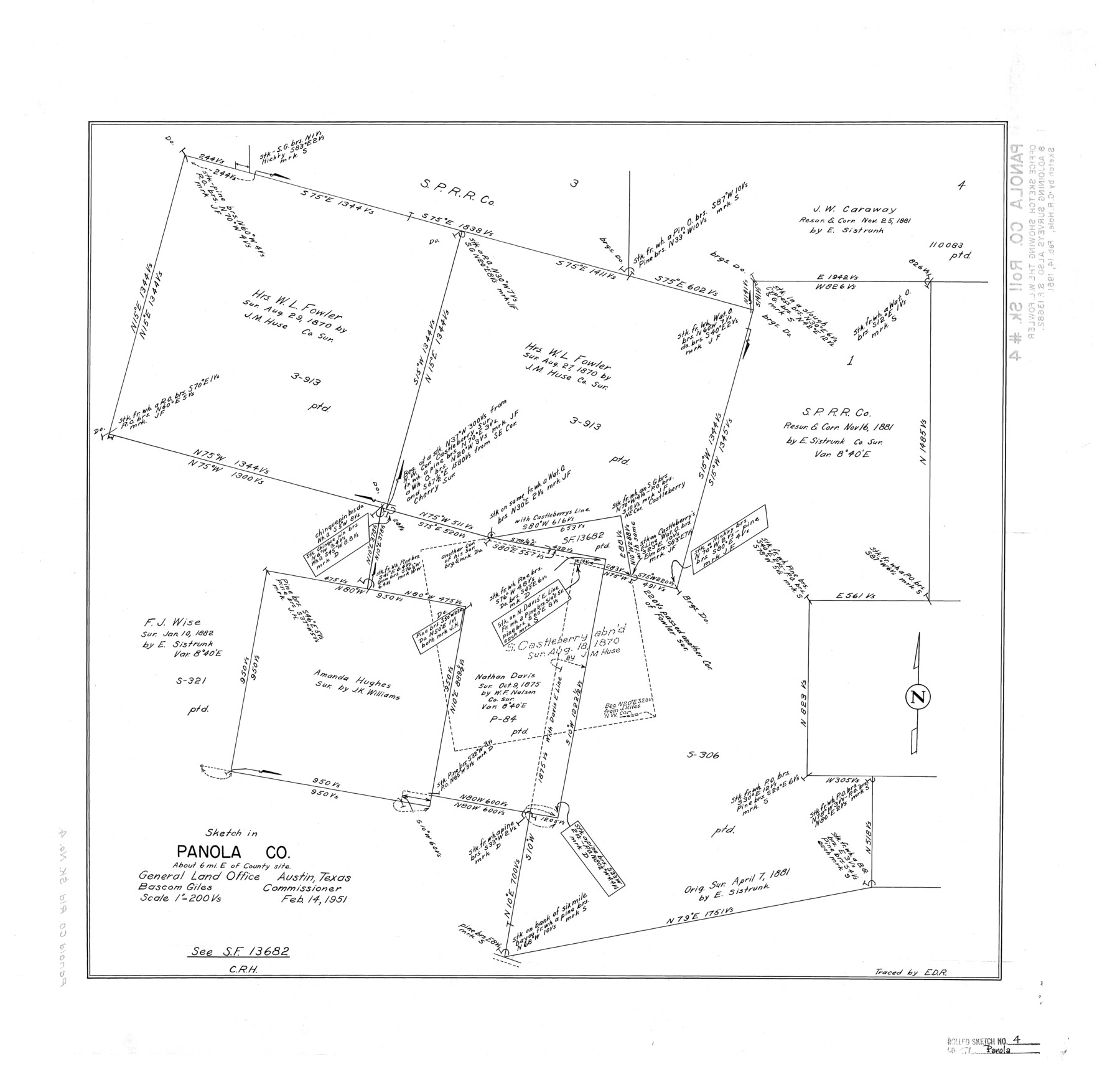
Panola County Rolled Sketch 4
Sketch in Panola Co. [regarding SF-13682]
-
Map/Doc
7198
-
Collection
General Map Collection
-
Object Dates
1951/2/14 (Creation Date)
-
Counties
Panola
-
Subjects
Surveying Rolled Sketch
-
Height x Width
25.4 x 26.1 inches
64.5 x 66.3 cm
-
Scale
1" = 200 varas
Part of: General Map Collection
Real County Rolled Sketch 18

Print $20.00
- Digital $50.00
Real County Rolled Sketch 18
1986
Size 24.9 x 31.9 inches
Map/Doc 7468
Smith County Rolled Sketch 6D2

Print $2.00
- Digital $50.00
Smith County Rolled Sketch 6D2
Size 11.3 x 8.9 inches
Map/Doc 76014
County Map of Texas and Indian Territory

Print $20.00
- Digital $50.00
County Map of Texas and Indian Territory
1881
Size 13.1 x 9.9 inches
Map/Doc 94153
Flight Mission No. BRE-3P, Frame 96, Nueces County

Print $20.00
- Digital $50.00
Flight Mission No. BRE-3P, Frame 96, Nueces County
1956
Size 18.3 x 22.2 inches
Map/Doc 86827
Flight Mission No. DQN-1K, Frame 140, Calhoun County

Print $20.00
- Digital $50.00
Flight Mission No. DQN-1K, Frame 140, Calhoun County
1953
Size 18.5 x 22.2 inches
Map/Doc 84203
Bandera County Sketch File 22

Print $4.00
- Digital $50.00
Bandera County Sketch File 22
Size 12.6 x 7.9 inches
Map/Doc 14012
Map of the River Sabine from Logan's Ferry to 32nd degree of north latitude

Print $2.00
- Digital $50.00
Map of the River Sabine from Logan's Ferry to 32nd degree of north latitude
1841
Size 8.6 x 10.5 inches
Map/Doc 65388
Baylor County Boundary File 4

Print $6.00
- Digital $50.00
Baylor County Boundary File 4
Size 11.2 x 8.6 inches
Map/Doc 50389
Flight Mission No. DCL-6C, Frame 21, Kenedy County

Print $20.00
- Digital $50.00
Flight Mission No. DCL-6C, Frame 21, Kenedy County
1943
Size 18.7 x 22.5 inches
Map/Doc 85878
Harrison County Working Sketch 33

Print $20.00
- Digital $50.00
Harrison County Working Sketch 33
2015
Size 19.8 x 22.8 inches
Map/Doc 93725
Flight Mission No. CON-2R, Frame 173, Stonewall County

Print $20.00
- Digital $50.00
Flight Mission No. CON-2R, Frame 173, Stonewall County
1957
Size 18.3 x 22.1 inches
Map/Doc 86991
Flight Mission No. CLL-1N, Frame 85, Willacy County

Print $20.00
- Digital $50.00
Flight Mission No. CLL-1N, Frame 85, Willacy County
1954
Size 18.4 x 22.1 inches
Map/Doc 87031
You may also like
Dimmit County Boundary File 5

Print $6.00
- Digital $50.00
Dimmit County Boundary File 5
Size 11.1 x 8.6 inches
Map/Doc 52577
Intracoastal Waterway in Texas - Corpus Christi to Point Isabel including Arroyo Colorado to Mo. Pac. R.R. Bridge Near Harlingen

Print $20.00
- Digital $50.00
Intracoastal Waterway in Texas - Corpus Christi to Point Isabel including Arroyo Colorado to Mo. Pac. R.R. Bridge Near Harlingen
1933
Size 27.9 x 41.0 inches
Map/Doc 61868
Harris County Rolled Sketch P4

Print $20.00
- Digital $50.00
Harris County Rolled Sketch P4
1920
Size 12.1 x 34.6 inches
Map/Doc 6143
Flight Mission No. DIX-6P, Frame 126, Aransas County

Print $20.00
- Digital $50.00
Flight Mission No. DIX-6P, Frame 126, Aransas County
1956
Size 19.3 x 22.9 inches
Map/Doc 83832
Williamson County Sketch File 28

Print $20.00
- Digital $50.00
Williamson County Sketch File 28
1941
Size 23.0 x 18.2 inches
Map/Doc 12695
Map of Crockett County

Print $40.00
- Digital $50.00
Map of Crockett County
1878
Size 62.6 x 49.7 inches
Map/Doc 93373
Nueces County Rolled Sketch 11

Print $40.00
- Digital $50.00
Nueces County Rolled Sketch 11
Size 43.2 x 56.8 inches
Map/Doc 9586
Flight Mission No. DQN-2K, Frame 28, Calhoun County

Print $20.00
- Digital $50.00
Flight Mission No. DQN-2K, Frame 28, Calhoun County
1953
Size 18.6 x 22.2 inches
Map/Doc 84235
Howard County Working Sketch Graphic Index

Print $20.00
- Digital $50.00
Howard County Working Sketch Graphic Index
1922
Size 42.5 x 36.3 inches
Map/Doc 76583
Navarro County Sketch File 12

Print $4.00
- Digital $50.00
Navarro County Sketch File 12
Size 7.0 x 7.0 inches
Map/Doc 32322
Willacy County Sketch File 3

Print $2.00
- Digital $50.00
Willacy County Sketch File 3
Size 8.5 x 11.0 inches
Map/Doc 90000
G. W. Cochran Farm Section 32, Block JS

Print $20.00
- Digital $50.00
G. W. Cochran Farm Section 32, Block JS
1943
Size 12.6 x 23.4 inches
Map/Doc 92328