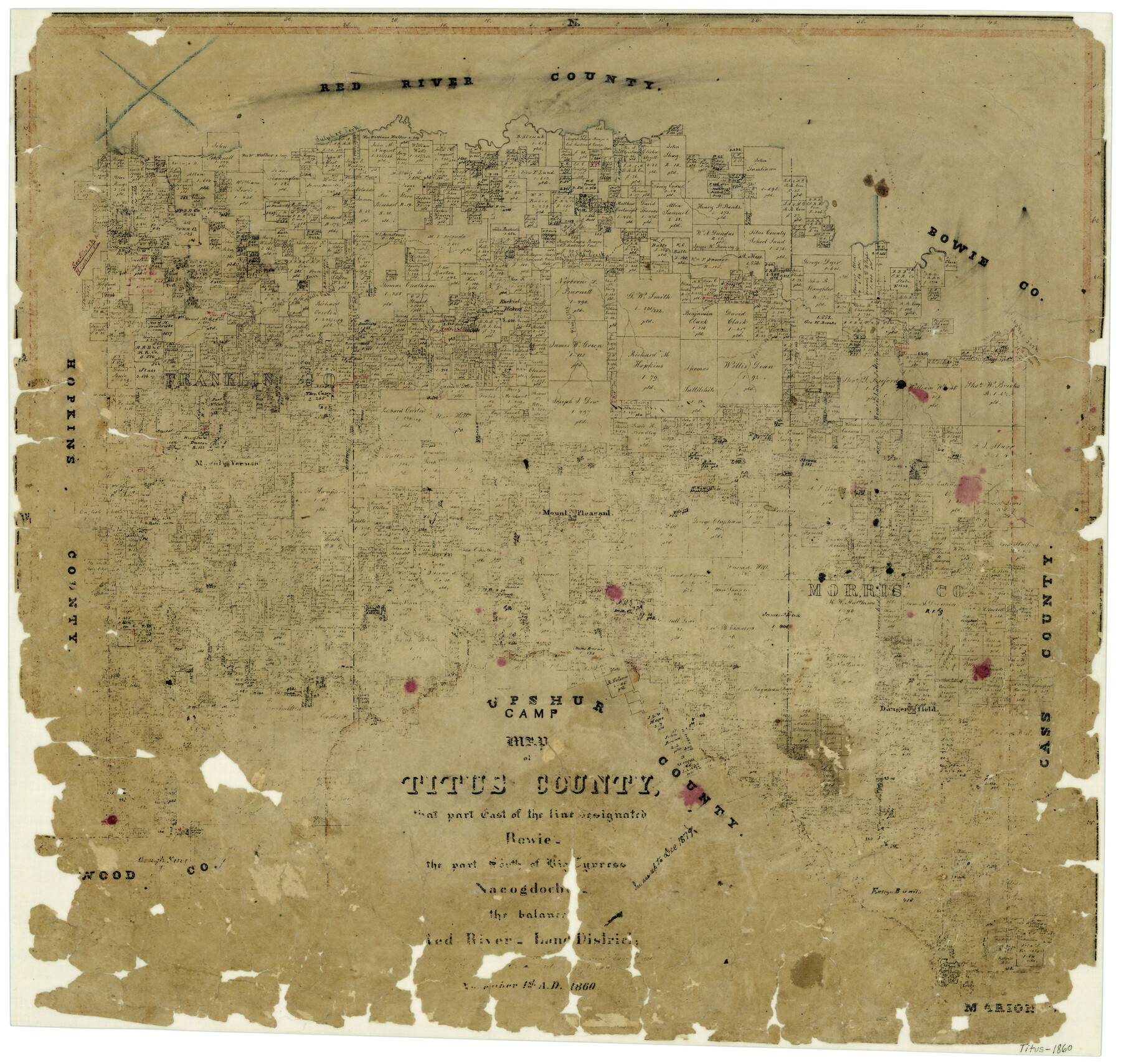
Map of Titus County
-
Map/Doc
4081
-
Collection
General Map Collection
-
Object Dates
11/1/1860 (Creation Date)
-
Counties
Titus
-
Subjects
County
-
Height x Width
20.9 x 21.8 inches
53.1 x 55.4 cm
-
Comments
Note on map: "In use up to December 1879".
-
Features
Cousin Creek
Snake Creek
White Oak Creek
Pine Creek
Horse Creek
Village Creek
Mount Vernon
Mount Pleasant
Tinkersley Creek
Blundell's Creek
Dangerfield
Sulphur Fork of Red River
Part of: General Map Collection
Comanche County Working Sketch 23

Print $20.00
- Digital $50.00
Comanche County Working Sketch 23
1974
Size 15.7 x 24.7 inches
Map/Doc 68157
Palo Pinto County Working Sketch 23

Print $40.00
- Digital $50.00
Palo Pinto County Working Sketch 23
1985
Map/Doc 71406
Reagan County Sketch File 14

Print $6.00
- Digital $50.00
Reagan County Sketch File 14
Size 11.3 x 8.8 inches
Map/Doc 34993
Webb County Rolled Sketch 48

Print $20.00
- Digital $50.00
Webb County Rolled Sketch 48
1943
Size 20.1 x 37.3 inches
Map/Doc 8204
Montgomery County Rolled Sketch 42

Print $20.00
- Digital $50.00
Montgomery County Rolled Sketch 42
1939
Size 14.1 x 20.1 inches
Map/Doc 6818
Flight Mission No. DAG-23K, Frame 179, Matagorda County

Print $20.00
- Digital $50.00
Flight Mission No. DAG-23K, Frame 179, Matagorda County
1953
Size 18.5 x 22.4 inches
Map/Doc 86514
Coke County Sketch File 37

Print $6.00
- Digital $50.00
Coke County Sketch File 37
2004
Size 11.0 x 8.5 inches
Map/Doc 82988
Pecos County Working Sketch 109

Print $40.00
- Digital $50.00
Pecos County Working Sketch 109
1972
Size 34.8 x 56.9 inches
Map/Doc 71582
Aransas County Sketch File 34

Print $54.00
- Digital $50.00
Aransas County Sketch File 34
1919
Size 14.3 x 8.5 inches
Map/Doc 13320
San Patricio County Rolled Sketch 42

Print $20.00
- Digital $50.00
San Patricio County Rolled Sketch 42
Size 18.6 x 37.3 inches
Map/Doc 7728
Parker County Working Sketch 12

Print $20.00
- Digital $50.00
Parker County Working Sketch 12
1974
Map/Doc 71462
San Patricio County NRC Article 33.136 Sketch 4

Print $3.00
- Digital $50.00
San Patricio County NRC Article 33.136 Sketch 4
Size 11.0 x 17.0 inches
Map/Doc 94695
You may also like
Flight Mission No. CRC-4R, Frame 102, Chambers County

Print $20.00
- Digital $50.00
Flight Mission No. CRC-4R, Frame 102, Chambers County
1956
Size 18.5 x 22.4 inches
Map/Doc 84899
The Republic County of Lamar. December 26, 1842

Print $20.00
The Republic County of Lamar. December 26, 1842
2020
Size 16.4 x 21.7 inches
Map/Doc 96205

Kinney County Rolled Sketch 3

Print $20.00
- Digital $50.00
Kinney County Rolled Sketch 3
Size 31.4 x 23.2 inches
Map/Doc 6535
Maps & Lists Showing Prison Lands (Oil & Gas) Leased as of June 1955

Digital $50.00
Maps & Lists Showing Prison Lands (Oil & Gas) Leased as of June 1955
1930
Size 24.4 x 26.8 inches
Map/Doc 62876
[Stone, Kyle and Kyle Block M6]
![90403, [Stone, Kyle and Kyle Block M6], Twichell Survey Records](https://historictexasmaps.com/wmedia_w700/maps/90403-1.tif.jpg)
Print $2.00
- Digital $50.00
[Stone, Kyle and Kyle Block M6]
1904
Size 12.7 x 9.0 inches
Map/Doc 90403
Montgomery County Sketch File 33A

Print $20.00
- Digital $50.00
Montgomery County Sketch File 33A
1948
Size 21.3 x 28.3 inches
Map/Doc 42124
Tabula Terre Nove

Print $20.00
- Digital $50.00
Tabula Terre Nove
1513
Size 18.7 x 24.6 inches
Map/Doc 93800
Platt [sic] of Late Surveys on Carancahua, Jackson County
![78360, Platt [sic] of Late Surveys on Carancahua, Jackson County, General Map Collection](https://historictexasmaps.com/wmedia_w700/maps/78360.tif.jpg)
Print $2.00
- Digital $50.00
Platt [sic] of Late Surveys on Carancahua, Jackson County
Size 10.9 x 8.0 inches
Map/Doc 78360
[Sketch in Hartley County]
![90770, [Sketch in Hartley County], Twichell Survey Records](https://historictexasmaps.com/wmedia_w700/maps/90770-1.tif.jpg)
Print $20.00
- Digital $50.00
[Sketch in Hartley County]
Size 29.1 x 21.7 inches
Map/Doc 90770
Pecos County Rolled Sketch 54

Print $11.00
- Digital $50.00
Pecos County Rolled Sketch 54
1916
Size 9.7 x 15.0 inches
Map/Doc 48099
Uvalde County

Print $20.00
- Digital $50.00
Uvalde County
1915
Size 43.4 x 46.4 inches
Map/Doc 63092